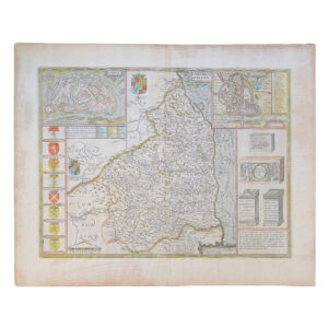
A Mapp Of Ye County of Northumberland With Ye Isles Of Farne & Holy Island – 1673
Cartographer: Richard Blome
Price: £145 including postage in the UK
Publication Date: 1673
Edition: First edition
Sheet Size: 30.8cm x 37.7cm
Condition: Very good
Condition:
From ‘Britannia, or a Geographical Description of the Kingdom of England, Scotland and Ireland’. Original copper-engraved map. Sheet size: 30.8cm x 37.7cm. Early hand-colouring. Minor age-toning and foxing. Residual evidence of a previous mount to the margins. An uncommon 17th century map of Northumberland which is in very good condition overall.
Richard Blome: A Brief Biography
Richard Blome (c. 1641–1705) was an English cartographer, engraver, and publisher whose work played a significant role in the commercialisation and popularisation of maps in Restoration and late Stuart England. Though not a surveyor or original cartographic innovator in the manner of Saxton or Speed, Blome was a skilled compiler, entrepreneur, and self-promoter, instrumental in making geographic knowledge more widely available during a period of expanding literacy, trade, and imperial ambition.
His career illustrates the transition of English cartography from elite scholarly production to market-driven publishing.
- Early Life and Background
Very little is known with certainty about Blome’s early life. He was probably born around 1641, during the political upheavals leading to the English Civil War.
What is clear is that:
- He did not come from the university-educated antiquarian tradition
- He was trained in engraving and publishing, rather than surveying or mathematics
- His professional identity was shaped by London’s vibrant print trade
Blome emerged in the post-Restoration period, when censorship eased and commercial publishing expanded rapidly.
- Entry into Cartography and Publishing
Blome established himself in London as:
- An engraver
- A map publisher
- A compiler of geographical works
Rather than conducting surveys, he:
- Reworked existing maps
- Commissioned engravers
- Adapted earlier cartographic sources
This was standard practice in the seventeenth century, though Blome would later be criticised for it more than many of his contemporaries.
- Britannia (1673): Blome’s Major Achievement
Concept and Ambition
Blome’s most important work is Britannia (1673), an atlas of England and Wales. It was conceived as a direct competitor to the county atlases of John Speed, but aimed at a broader and less elite market.
Production
- The maps were engraved largely by Wenceslaus Hollar and other skilled craftsmen
- Many maps were derived from earlier sources, including Speed and Saxton
- Decorative elements were simplified to reduce costs
Content
Each county map was accompanied by:
- Short descriptive text
- Lists of towns and hundreds
- Practical geographical information
The emphasis was on utility rather than antiquarian richness.
- Controversy and Criticism
Accusations of Plagiarism
Blome’s reputation suffered during his lifetime due to:
- Allegations that he copied earlier maps without sufficient acknowledgement
- Public criticism from rivals and antiquarians
Some critics accused him of misrepresentation and exaggeration in advertising his work as “new”.
Modern Reassessment
Modern historians tend to view Blome more sympathetically:
- Reuse and adaptation were normal practices
- His real contribution lay in distribution, accessibility, and standardisation
- He helped sustain an English cartographic industry between great innovators
Blome was less a creator than a mediator of geographic knowledge.
- Expansion Beyond Britain
Blome did not confine himself to county mapping. His output included:
- World maps
- Continental maps
- Historical and political geography
He also published works on:
- Cosmography
- History
- Heraldry
These reflected England’s growing global outlook in the late seventeenth century.
- Blome as Entrepreneur and Self-Promoter
Blome was an aggressive marketer:
- He issued proposals and prospectuses
- Promoted his works through subscriptions
- Emphasised novelty and authority
This entrepreneurial energy was essential to survival in a competitive print market, though it also attracted hostility from rivals.
- Style and Cartographic Character
Blome’s maps are characterised by:
- Clear, functional layout
- Reduced decorative content compared with Speed
- Emphasis on legibility and coverage
They lack the heraldic and historical richness of earlier atlases but gain in practical usability.
- Later Life and Decline
Despite his prolific output, Blome struggled financially in later life:
- The market for atlases became increasingly crowded
- Printing costs were high
- Competition intensified
He died in 1705, apparently without great wealth or lasting institutional support.
- Legacy and Historical Significance
Cartographic Importance
Richard Blome’s significance lies in:
- Sustaining English cartography during a transitional period
- Broadening access to maps beyond elite collectors
- Demonstrating the growing role of commercial publishing
Cultural Role
He represents the Restoration print entrepreneur, operating between scholarship and commerce.
Modern Reputation
Today, Blome is valued as:
- A key figure in the dissemination of geographic knowledge
- An example of how maps entered everyday intellectual life
- A reminder that cartographic history depends as much on publishers as on innovators
Conclusion
Richard Blome was not a great cartographic visionary, but he was an essential figure in the history of English mapping. Through compilation, publication, and commercial energy, he helped ensure that maps became widely available tools, not rare scholarly artefacts. His career reflects the realities of seventeenth-century print culture, where authority, originality, and entrepreneurship were constantly negotiated.
Blome’s work stands as evidence that the history of cartography is shaped not only by genius, but by those who make knowledge circulate.
Why buy from us?
At Hornseys, we are committed to offering items that meet the highest standards of quality and authenticity. Our collection is meticulously curated to ensure that each item is a valuable and authentic piece of history. Here’s what sets us apart:
- Authenticity and Provenance: Every item is researched, collated, and verified for authenticity.
- Expert Curation: Each item is selected with a keen eye for significance, condition, and rarity, ensuring a collection that is both diverse and distinguished.
- Customer Satisfaction: We strive to provide an exceptional customer experience, from detailed descriptions and provenance to secure and prompt delivery of your purchase.
- Returns Policy: We offer an unconditional guarantee on every item. If you wish to make a return, items may be sent back to us within fourteen days of receipt for any reason. We request advance notification of returns, and items must be returned in the same condition as sent for a full refund.
Explore Our Collection:
Visit Hornseys to explore our fine collection of rare and signed books, maps, artwork and objects. Whether you are an avid collector or looking for a special gift, our selection offers something truly unique. Located in the picturesque Yorkshire Dales, our Ripon gallery has been a haven for book lovers, art enthusiasts, and collectors since 1976.
Thank you for looking.