-

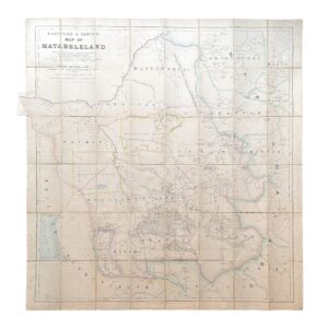
R.T.M. – Rio Tinto Mining Company Limited – General Plan Of Works – c.1874-1876
£15,000.00Rio Tinto Mining Company Limited
-
-
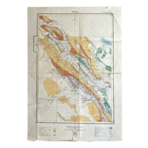
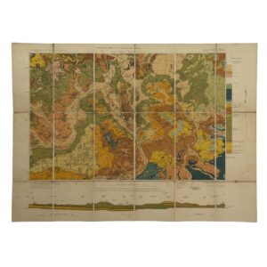
Iran – Persia – Qasr-i-Shirin Area. To Accompany Report M.H.L. 7 – Geological Map – 1929
£2,000.00Anglo-Persian Oil Company
-
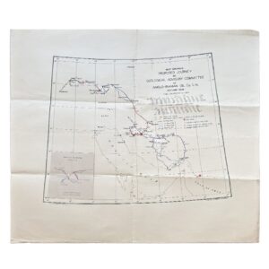
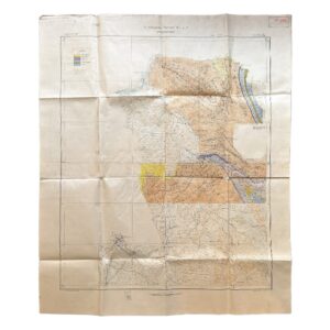
Iran – Map Showing Proposed Journey By Geological Advisory Committee Of Anglo-Iranian Oil Co. Ltd., Autumn 1936
£1,800.00Geological Advisory Committee (Iran)
-
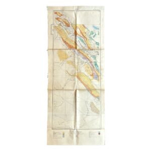
Persia. No. 9 H.E. 10.E – Geological Map Of South-West Iran Including The Masjid-I-Sulaiman And Haft Kel Oil Regions – 1929
£950.00Cornes, H & Anglo-Persian Oil Company (A.P.O.C.)
-
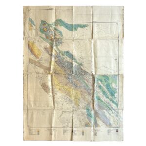
Persia. No. 9 H.E. 10.E – Geological Map Of South-West Iran Including The Masjid-I-Sulaiman And Haft Kel Oil Regions – 1929/35
£950.00Cornes, H & Anglo-Persian Oil Company (A.P.O.C.)
-

Iran – Persia – Masjid-i-Sulaiman Road Map – South-West Iran – Khuzestan Province – Masjid-i-Sulaiman Oilfield District – c.1949-54
£750.00Anglo-Iranian Oil Company (A.I.O.C.)
-

-

Tectonic Map Of Australia – First Edition – Map On Four Sheets
£650.00Bureau of Mineral Resources, Geology and Geophysics
-
-
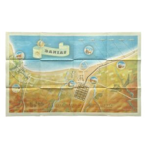
Banias – Iraq Petroleum Company Limited – Sea Terminal of the Kirkuk–Banias Pipeline – 1952
£500.00Iraq Petroleum Company Limited
-
Persia – A.P.O.C. Geological Map Of South-West Iran – Zagros Oilfields – Sheet No. 10 I & 10 J – 1929
£500.00Cornes, H & Anglo-Persian Oil Company (A.P.O.C.)
-

Geological Map Of Israel – Revised Edition – 1976 – Map On Two Sheets
£450.00Picard, L. Y, Golani, U, Bentor, Y. K, Vroman, A & Zak, I
-

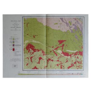
Geological Map Of The Country Around Salisbury – Rhodesia – 1958 – First Edition
£245.00R. M. Tyndale-Biscoe
-

Geologic Map of California Olaf P Jenkins Edition Los Angeles Sheet
£195.00Jennings, Charles W & Strand, Rudolph G
-

-

Geological Map Of The Colony Of The Cape Of Good Hope Sheet 4: Paternoster – Langebaan – Darling – Malmesbury
£175.00Rogers, A. W, Schwarz, E. H. L & Du Toit, A. L
-

Geological Map Of The Colony Of The Cape Of Good Hope Sheet 1: Cape Town – Stellenbosch – Somerset West – Robertson – Napier
£175.00Rogers, A. W, Schwarz, E. H. L & Du Toit, A. L
-

Sheet 12 – Pilandsberg – Union Of South Africa Department Of Mines And Industries – Geological Survey
£145.00Hall, A. L & Humphrey, W. A
-

Geological Map Of The Colony Of The Cape Of Good Hope Sheet 2: Riversdale – Heidelberg – Port Beaufort – Swellendam – Bredasdorp
£145.00Rogers, A. W & Schwarz, E. H. L
-
Geological Survey of England and Wales / Ordnance Survey – Parts Of Sheets 236, 237, 253 and 254 – Oxford – 1908 – Folding Map
£125.00Geological Survey of England and Wales / Ordnance Survey
-

Sheet 2 – Pienaars River – Union Of South Africa Department Of Mines And Industries – Geological Survey
£125.00Kynaston, H, Mellor, E. T, Hall, A. L & Humphrey, W. A
-

Sheet 9 – Marico – Union Of South Africa Department Of Mines And Industries – Geological Survey
£125.00Hall, A. L & Humphrey, W. A
-

Sheet 10 – Nylstroom – Union Of South Africa Department Of Mines And Industries – Geological Survey
£125.00Mellor, E. T, Kynaston, H & Humphrey, W. A
-

Geological Map Of The Colony Of The Cape Of Good Hope Sheet 46 – Warrenton – Barkly West
£125.00Du Toit, A. L
-

-

Geological Map Of The Colony Of The Cape Of Good Hope Sheet 26 – Dordrecht – Barkly East
£125.00Du Toit, A. L
-
Geological Map Of The Colony Of The Cape Of Good Hope Sheet 32 – Van Wyk’s Vlei
£125.00Du Toit, A. L & Rogers, A. W.
-

Geological Map Of The Colony Of The Cape Of Good Hope Sheet 41 – Griqua Town
£125.00Du Toit, A. L & Rogers, A. W.
-

Geological Map Of The Colony Of The Cape Of Good Hope Sheet 40 – Marydale
£125.00Du Toit, A. L & Rogers, A. W.
-

-
