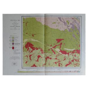
Geological Map Of The Colony Of The Cape Of Good Hope Sheet 46 – Warrenton – Barkly West
Du Toit, A. L
£125.00
Availability: In stock
Product Description
Geological Map Of The Colony Of The Cape Of Good Hope Sheet 46 – Warrenton – Barkly West
Cartographer: Du Toit, A. L
Publisher: The Geological Commission
Price: £125 (post-free in the UK)
Publication Date: 1907
Edition: 1st edition thus
Format: Lithograph
Condition: In very good condition
Sheet Size: 64cm x 56.2cm
Condition:
Lithograph. Sheet Size: 64cm x 56.2cm. Neat ink number to lower right margin. Old fold lines. Slightly creased, marked, dusty and rubbed with a couple of very short closed tears to the margin. Colouration very bright and clean. A very good copy. Very scarce.
Location: Pocket RSAGEOL: SR: 002865
Geology Of The Warrenton – Barkly West Region: An Historical Overview
- Introduction and Geographic Setting
The Warrenton–Barkly West region lies within the Northern Cape Province of South Africa, northwest of Kimberley, along the Vaal River. This area is historically significant for its role in the early diamond mining industry, and geologically important for its position at the boundary between the Kaapvaal Craton and the Kalahari Craton, underlain by Archaean basement rocks, Proterozoic sediments, and kimberlite intrusions.
The region is shaped by a complex interplay of ancient tectonic processes, Mesozoic volcanic activity, and fluvial reworking of mineral-rich gravels.
- Basement Geology: The Archaean Core
At depth, the region rests upon the Kaapvaal Craton, a block of ancient continental crust that formed over 3 billion years ago. Although mostly obscured by younger cover rocks and sediments, this craton provides the tectonic stability necessary for the preservation of long-lived geological units and the emplacement of kimberlite pipes, some of which are diamondiferous.
Where exposed or inferred, the basement consists of:
- Granitoid gneisses and greenstone remnants
- Migmatitic complexes, indicating deep crustal melting
- Highly metamorphosed tonalitic and granodioritic suites
These basement rocks form the structural backbone for the later depositional and volcanic events that shaped the modern geology.
- The Griqualand West Sequence: Proterozoic Platform Sedimentation
Overlying the craton are sedimentary rocks of the Transvaal Supergroup, especially those of the Ghaap Group and Postmasburg Group, deposited during the Palaeoproterozoic era.
Key lithologies include:
- Dolomites and limestones of the Campbell Rand Subgroup
- Banded iron formations (BIFs) of the Kuruman Formation
- Shales and cherts, indicating marine shelf conditions
These units represent deposition on a passive continental margin, and their iron-rich layers are significant for understanding early oxygenation and chemical sedimentation. They also provided structural traps and host rocks later influenced by kimberlite intrusions and karst development.
- Kimberlite Intrusions and Diamond Geology
The Warrenton–Barkly West region is globally significant for its association with kimberlite pipes, which are the primary sources of diamonds. These intrusions, emplaced during the Cretaceous period (roughly 90–120 million years ago), were driven by deep mantle processes and rapidly transported mantle-derived rocks and xenoliths to the surface.
Notable features include:
- Kimberlite pipes and dykes, some of which are diamondiferous
- Alluvial diamond deposits, formed through erosion and river transport of material from primary sources
- Ancient river terraces that contain diamond-rich gravels
The Vaal River, in particular, played a key role in reworking and concentrating diamonds, giving rise to secondary deposits historically mined from riverbeds and terrace gravels.
- Surface Geology and River Terraces
The Vaal River system dominates the surface geomorphology of the region, cutting through the ancient rocks and shaping extensive terraced landscapes.
These terraces represent successive episodes of:
- Downcutting and lateral erosion
- Gravel deposition during periods of higher discharge
- Concentration of resistant minerals, including diamonds, in fluvial lag deposits
The older gravels (known colloquially as “blue ground” and “red ground”) are of particular interest for their economic value. The geomorphological context makes the region a classic case of placer diamond formation.
- Quaternary and Recent Deposits
Modern surficial geology includes:
- Alluvium, especially along the Vaal and its tributaries
- Colluvium and pedogenic calcretes, formed through soil development in semi-arid conditions
- Thin Kalahari sands, blown in during more recent aeolian phases
These deposits are important for agriculture, water supply, and also influence the accessibility and preservation of deeper gravels and mineral layers.
- Structural and Tectonic Considerations
While the region is relatively stable tectonically, its geology has been affected by:
- Ancient fault zones, particularly the Vaal River Fault
- Karst development in dolomitic rocks, forming sinkholes and caves
- Minor flexuring and uplift during Mesozoic rifting and kimberlite emplacement
These structures have influenced drainage patterns, rock deformation, and mineral localisation.
- Hydrogeology
Groundwater is sourced from a mix of:
- Karstic aquifers in dolomites
- Fractured basement rocks
- Alluvial aquifers associated with the Vaal River system
Water quality and availability vary, with salinity and fluoride occasionally exceeding safe levels in confined dolomitic settings. Careful borehole siting is essential for sustainable use.
- Economic Geology and Mining History
The Barkly West area holds a prominent place in the history of South African mining. Key developments include:
- The discovery of alluvial diamonds in the mid-19th century, predating the Kimberley rush
- The establishment of open-cast and pit mining operations in river terraces and old channels
- Continued small-scale mining and prospecting for both primary (kimberlite) and secondary (alluvial) diamond sources
Although large-scale mining has declined, artisanal and historical sites remain active and of heritage importance.
- Scientific and Educational Significance
The Warrenton–Barkly West region is studied for its:
- Role in diamond genesis and alluvial concentration
- Preservation of Palaeoproterozoic platform sequences
- Exposure of deep-time stratigraphy, tectonic features, and modern geomorphic processes
It also offers valuable teaching examples in economic geology, sedimentology, and structural geology, frequently visited by geological surveys and academic institutions.
Conclusion
The geology of the Warrenton–Barkly West region weaves together a complex narrative of Archaean crustal stability, Proterozoic marine sedimentation, Cretaceous volcanism, and modern fluvial reworking. It remains a region of profound geological interest and enduring economic relevance, particularly for its role in the global history of diamond discovery and exploitation.
Today, its landscapes continue to reflect the legacy of these deep-time events, offering insights into both Earth’s interior processes and the surface dynamics that shape mineral wealth.
A. L. Du Toit: A Short Biography
Early Life and Education
Alexander Logie du Toit was born on 14 March 1878 in Newlands, Cape Town, within the then Cape Colony of South Africa. He was raised in a cultured and academically inclined household of Scots descent, and from an early age demonstrated a marked interest in the natural world.
Du Toit received his schooling at the South African College School and later enrolled at the South African College (now the University of Cape Town), where he pursued studies in geology, chemistry, and physics. He continued his education in Britain, studying mining engineering at the Royal Technical College in Glasgow and gaining practical experience in geological fieldwork and mapping.
Early Career and Geological Survey Work
Upon returning to South Africa in the early 1900s, du Toit joined the Geological Commission of the Cape of Good Hope, later absorbed into the Geological Survey of the Union of South Africa. His initial assignments took him to the Karoo Basin, where he began conducting detailed fieldwork and geological mapping, especially in the semi-arid interior of the country.
His early work included:
- Mapping of coal-bearing strata in the Karoo Supergroup
- Detailed studies of stratigraphy and sedimentology
- Investigations into the economic potential of South Africa’s coal and mineral resources
Du Toit rapidly distinguished himself through his meticulous field observations, clear cartographic skills, and interpretive insights. He played a major role in the development of South Africa’s first comprehensive geological maps of key economic regions.
Pioneering Work on Continental Drift
Du Toit’s greatest contribution to science lay in his early and robust support for the then-controversial theory of continental drift. Building upon the ideas of Alfred Wegener, the German meteorologist and geophysicist who proposed that continents had once formed a single landmass (Pangaea), du Toit became one of the theory’s most articulate and respected advocates.
In 1923, he undertook an ambitious geological expedition to South America, specifically to Argentina and Brazil, to compare geological formations with those in southern Africa. His comparative analysis of:
- Fossil flora (notably Glossopteris)
- Stratigraphic sequences
- Glacial deposits
- Petrological similarities
provided compelling evidence for the idea that Africa and South America had once been joined as part of the southern supercontinent Gondwana.
This work culminated in the publication of his landmark book, “Our Wandering Continents” (1937), in which he elaborated on the geological, palaeontological, and climatological data supporting continental drift theory. Although controversial at the time, the book would later be seen as a foundational text in support of what would evolve into the theory of plate tectonics.
Scientific Recognition and International Engagement
Despite initial scepticism from many geologists, particularly in North America and Britain, du Toit’s work earned widespread respect for its rigour, clarity, and global vision. He was known not only for the detail of his fieldwork but also for his ability to synthesise large bodies of data across continents—an approach that was well ahead of its time.
He received numerous honours and appointments, including:
- Fellowship of the Royal Society of South Africa
- Membership in the Geological Society of London
- Honorary doctorates from South African and international universities
Du Toit remained a modest and disciplined scholar, focused on the scientific method and the global implications of geological phenomena. His dedication to field-based observation and intercontinental comparison made him a model of methodological integrity.
Later Life and Legacy
Alexander du Toit retired from official survey work in the 1940s but continued to publish, correspond, and advise until his death in Cape Town in 1948. At the time of his passing, the theory of continental drift remained controversial, yet within two decades it would be revitalised and universally accepted under the framework of plate tectonics—a scientific revolution to which du Toit had made a crucial early contribution.
Today, du Toit is recognised as one of South Africa’s most distinguished geologists, and one of the key transitional figures in the history of Earth science. His legacy includes:
- The Du Toit Nunataks in Antarctica, named in his honour
- His enduring role in Gondwana studies and palaeogeographic reconstruction
- The development of modern geological mapping and stratigraphic correlation in southern Africa
Conclusion
L. du Toit was a geologist of remarkable vision, discipline, and intellectual courage. At a time when the idea of drifting continents was ridiculed, he pursued a global, integrative approach to geological science, based on painstaking fieldwork and comparative analysis.
His work not only advanced understanding of South Africa’s geological foundations, but also helped lay the groundwork for the most significant paradigm shift in Earth sciences in the 20th century. Du Toit’s life exemplifies the qualities of curiosity, persistence, and scientific integrity, making him a figure of enduring importance in both national and international geological history.
SHOP WITH CONFIDENCE AT HORNSEYS
At Hornseys, we are dedicated to offering items that uphold the highest standards of quality and authenticity. Our collection of artwork is carefully curated to ensure that each item we offer is authentic, collated, and complete.
Here’s what sets us apart:
- Authenticity and Provenance: Each map is researched and verified for authenticity.
- Expert Curation: We entirely own all our artworks. We trust our taste and have invested heavily in it. We have confidence in all artwork that we offer for sale.
- Customer Satisfaction: We strive to provide an exceptional customer experience, from detailed descriptions and provenance to secure and prompt delivery of your purchase.
- Returns Policy: We offer an unconditional guarantee on every item. If, however, you wish to make a return, artworks may be sent back to us within fourteen days of receipt for whatever reason. We request that we are notified in advance if you wish to do so. They must be returned to us in the same condition as they were sent for a full refund.
OUR COMMITMENT TO QUALITY AND SERVICE
Understanding the value and rarity of these items, we ensure that every aspect of your purchase meets the highest standards of quality and service. This includes:
- Free Expedited, Tracked, and Insured Delivery within the UK: Ensuring that your artwork arrives safely and promptly.
- Fully-Insured Worldwide Delivery: Offering peace of mind for international collectors with reliable and secure shipping options.
EXPLORE OUR COLLECTION
Visit Hornseys today to explore our fine collection of maps and other artworks. Whether you are an avid collector or looking for a special gift, our selection offers something truly unique. Located since 1976 in Ripon in the picturesque Yorkshire Dales, we are recognized as a destination gallery for tastefully curated artwork, rare maps, design, and fine books.
Related products


You may also like…

Geological Map Of The Colony Of The Cape Of Good Hope Sheet 32 – Van Wyk’s Vlei
£125.00Du Toit, A. L & Rogers, A. W.
Geological Map Of The Colony Of The Cape Of Good Hope Sheet 41 – Griqua Town
£125.00Du Toit, A. L & Rogers, A. W.
Geological Map Of The Colony Of The Cape Of Good Hope Sheet 40 – Marydale
£125.00Du Toit, A. L & Rogers, A. W.