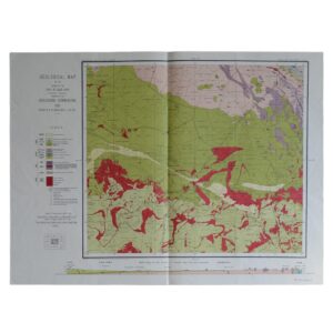
Geological Map Of The Colony Of The Cape Of Good Hope Sheet 26 – Dordrecht – Barkly East
Du Toit, A. L
£125.00
Availability: In stock
Product Description
Geological Map Of The Colony Of The Cape Of Good Hope Sheet 26 – Dordrecht – Barkly East
Cartographer: Du Toit, A. L
Publisher: The Geological Commission
Price: £125 (post-free in the UK)
Publication Date: 1912
Edition: 1st edition thus
Format: Lithograph
Condition: In very good condition
Sheet Size: 60.9cm x 80.7cm
Condition:
Lithograph. Sheet Size: 60.9cm x 80.7cm. Neat institutional stamp to upper margin. Neat ink number to lower right margin. Old fold lines. Slightly creased, marked, dusty and rubbed with a couple of very short closed tears to the margin. Colouration very bright and clean. A very good copy. Very scarce
Location: Pocket RSAGEOL: SR: 002863
Geology Of The Dordrecht – Barkly East Region: An Historical Overview
- Introduction and Geographic Context
The towns of Dordrecht and Barkly East are situated in the Eastern Cape Province of South Africa, within the southern part of the Drakensberg region. This area lies near the contact zone between the main Karoo sedimentary sequence and the Drakensberg volcanic plateau, making it geologically significant for its well-preserved late Palaeozoic to early Mesozoic sedimentary and volcanic successions.
The terrain is marked by steep escarpments, incised river valleys, and high-altitude grasslands, reflecting both the underlying stratigraphy and long-term erosional processes that have shaped the landscape.
- Stratigraphic Framework: The Karoo Supergroup
The entire region falls within the Main Karoo Basin, one of the largest sedimentary basins in the southern hemisphere. The sedimentary rocks here belong to the Karoo Supergroup, which spans a geological period from the late Carboniferous (~300 million years ago) to the early Jurassic (~180 million years ago).
In the Dordrecht–Barkly East region, the key stratigraphic units include:
- Beaufort Group (especially the Tarkastad Subgroup)
- Molteno Formation
- Elliot Formation
- Clarens Formation
- Drakensberg Group basalts (overlying the sedimentary units)
Each of these layers records a distinct phase of environmental and geological evolution.
- Beaufort Group and Tarkastad Subgroup (Late Permian to Early Triassic)
At the base of the local stratigraphy lies the Beaufort Group, particularly the upper part known as the Tarkastad Subgroup. These rocks were deposited in extensive river systems during the post-glacial retreat of the late Permian period.
- Dominated by sandstones, siltstones, and mudstones
- Represent fluvial and floodplain environments
- Contain important vertebrate fossils, particularly of therapsids (mammal-like reptiles) that thrived in post-extinction ecosystems
The Beaufort sediments are deeply eroded in river valleys and form the lower slopes of the surrounding escarpments.
- Molteno Formation (Late Triassic)
Overlying the Beaufort Group is the Molteno Formation, composed primarily of:
- Quartzose sandstones with large-scale cross-bedding
- Conglomerates and mudstone interbeds
- Well-preserved plant fossils, including fossilised wood and leaf impressions
These rocks were laid down in braided river systems and reflect a semi-arid but seasonally dynamic environment. The Molteno is a key palaeobotanical unit, recording the late Triassic flora of Gondwana.
- Elliot Formation (Late Triassic to Early Jurassic)
The Elliot Formation is one of the region’s most prominent geological features, forming steep cliffs and rocky outcrops.
- Consists of red to buff mudstones, siltstones, and fine-grained sandstones
- Deposited in meandering rivers, floodplains, and lacustrine settings
- Contains abundant dinosaur fossils, particularly early sauropodomorphs such as Massospondylus
The Elliot Formation is renowned for its palaeontological value, and the Dordrecht–Barkly East region forms part of the wider Stormberg Group fossil corridor.
- Clarens Formation (Early Jurassic)
Above the Elliot lies the Clarens Formation, representing the last sedimentary unit before volcanic activity commenced.
- Composed of well-sorted aeolian sandstones
- Pale buff to white in colour, often forming rounded koppies and sandstone ridges
- Represents ancient desert dune systems formed in increasingly arid conditions
The Clarens Formation often weathers into spectacular landforms and provides a visual transition between the sedimentary units and the overlying basalts.
- Drakensberg Group (Early Jurassic Volcanism)
Crowning the sequence are the Drakensberg basalts, part of the Karoo Large Igneous Province, formed by extensive volcanic eruptions approximately 180 million years ago.
- These flood basalts are typically dark grey to black and form the high peaks and escarpments of the Drakensberg Mountains
- Characterised by columnar jointing, lava flow contacts, and occasional interbedded volcanic ash layers
- Mark the end of sedimentation in the Karoo Basin and signal major tectonic upheaval
In the Dordrecht–Barkly East area, the basalts are responsible for the elevated plateau and much of the mountainous terrain that defines the regional topography.
- Structural Geology and Landscape Evolution
Structurally, the region is relatively stable, with rocks exhibiting:
- Gently dipping strata, except near faults or escarpment edges
- Minor normal faulting, associated with the break-up of Gondwana
- Joints and fractures developed during cooling of the basalts and later erosion
Erosional processes, particularly along river systems like the Kraai River, have cut deeply into the geological sequence, creating dramatic gorges, cliffs, and waterfalls, and exposing a complete vertical section of the Karoo succession.
- Modern Surface Processes and Soils
The current geomorphology is shaped by:
- Periglacial and fluvial erosion, especially during colder Quaternary climates
- Frost action and sheet erosion on steep slopes
- Formation of colluvial fans and alluvial terraces
Soils are typically shallow and derived from the underlying sedimentary and volcanic rocks, influencing land use, particularly in sheep farming, wool production, and limited cropping on the more fertile valley floors.
- Scientific and Educational Significance
The geology of the Dordrecht–Barkly East region is of major academic and educational value:
- It offers one of the most continuous and accessible stratigraphic records of the upper Karoo Supergroup
- Provides critical evidence for continental sedimentation, palaeoclimate change, and the rise of dinosaurs
- Forms a natural laboratory for teaching stratigraphy, sedimentology, palaeontology, and volcanology
The area is also part of South Africa’s growing geoheritage network, attracting researchers and students from around the world.
Conclusion
The Dordrecht–Barkly East region presents a remarkably complete geological narrative of late Palaeozoic to early Jurassic Earth history. From ancient floodplains and desert dunes to the fiery basalts of the Drakensberg, the region’s geology has shaped both the landscape and the cultural history of the highlands.
Today, it continues to offer a rare opportunity to observe and study the interplay of sedimentation, life evolution, and volcanism in one of the most scenic and scientifically important parts of South Africa’s interior.
A. L. Du Toit: A Short Biography
Early Life and Education
Alexander Logie du Toit was born on 14 March 1878 in Newlands, Cape Town, within the then Cape Colony of South Africa. He was raised in a cultured and academically inclined household of Scots descent, and from an early age demonstrated a marked interest in the natural world.
Du Toit received his schooling at the South African College School and later enrolled at the South African College (now the University of Cape Town), where he pursued studies in geology, chemistry, and physics. He continued his education in Britain, studying mining engineering at the Royal Technical College in Glasgow and gaining practical experience in geological fieldwork and mapping.
Early Career and Geological Survey Work
Upon returning to South Africa in the early 1900s, du Toit joined the Geological Commission of the Cape of Good Hope, later absorbed into the Geological Survey of the Union of South Africa. His initial assignments took him to the Karoo Basin, where he began conducting detailed fieldwork and geological mapping, especially in the semi-arid interior of the country.
His early work included:
- Mapping of coal-bearing strata in the Karoo Supergroup
- Detailed studies of stratigraphy and sedimentology
- Investigations into the economic potential of South Africa’s coal and mineral resources
Du Toit rapidly distinguished himself through his meticulous field observations, clear cartographic skills, and interpretive insights. He played a major role in the development of South Africa’s first comprehensive geological maps of key economic regions.
Pioneering Work on Continental Drift
Du Toit’s greatest contribution to science lay in his early and robust support for the then-controversial theory of continental drift. Building upon the ideas of Alfred Wegener, the German meteorologist and geophysicist who proposed that continents had once formed a single landmass (Pangaea), du Toit became one of the theory’s most articulate and respected advocates.
In 1923, he undertook an ambitious geological expedition to South America, specifically to Argentina and Brazil, to compare geological formations with those in southern Africa. His comparative analysis of:
- Fossil flora (notably Glossopteris)
- Stratigraphic sequences
- Glacial deposits
- Petrological similarities
provided compelling evidence for the idea that Africa and South America had once been joined as part of the southern supercontinent Gondwana.
This work culminated in the publication of his landmark book, “Our Wandering Continents” (1937), in which he elaborated on the geological, palaeontological, and climatological data supporting continental drift theory. Although controversial at the time, the book would later be seen as a foundational text in support of what would evolve into the theory of plate tectonics.
Scientific Recognition and International Engagement
Despite initial scepticism from many geologists, particularly in North America and Britain, du Toit’s work earned widespread respect for its rigour, clarity, and global vision. He was known not only for the detail of his fieldwork but also for his ability to synthesise large bodies of data across continents—an approach that was well ahead of its time.
He received numerous honours and appointments, including:
- Fellowship of the Royal Society of South Africa
- Membership in the Geological Society of London
- Honorary doctorates from South African and international universities
Du Toit remained a modest and disciplined scholar, focused on the scientific method and the global implications of geological phenomena. His dedication to field-based observation and intercontinental comparison made him a model of methodological integrity.
Later Life and Legacy
Alexander du Toit retired from official survey work in the 1940s but continued to publish, correspond, and advise until his death in Cape Town in 1948. At the time of his passing, the theory of continental drift remained controversial, yet within two decades it would be revitalised and universally accepted under the framework of plate tectonics—a scientific revolution to which du Toit had made a crucial early contribution.
Today, du Toit is recognised as one of South Africa’s most distinguished geologists, and one of the key transitional figures in the history of Earth science. His legacy includes:
- The Du Toit Nunataks in Antarctica, named in his honour
- His enduring role in Gondwana studies and palaeogeographic reconstruction
- The development of modern geological mapping and stratigraphic correlation in southern Africa
Conclusion
L. du Toit was a geologist of remarkable vision, discipline, and intellectual courage. At a time when the idea of drifting continents was ridiculed, he pursued a global, integrative approach to geological science, based on painstaking fieldwork and comparative analysis.
His work not only advanced understanding of South Africa’s geological foundations, but also helped lay the groundwork for the most significant paradigm shift in Earth sciences in the 20th century. Du Toit’s life exemplifies the qualities of curiosity, persistence, and scientific integrity, making him a figure of enduring importance in both national and international geological history.
SHOP WITH CONFIDENCE AT HORNSEYS
At Hornseys, we are dedicated to offering items that uphold the highest standards of quality and authenticity. Our collection of artwork is carefully curated to ensure that each item we offer is authentic, collated, and complete.
Here’s what sets us apart:
- Authenticity and Provenance: Each map is researched and verified for authenticity.
- Expert Curation: We entirely own all our artworks. We trust our taste and have invested heavily in it. We have confidence in all artwork that we offer for sale.
- Customer Satisfaction: We strive to provide an exceptional customer experience, from detailed descriptions and provenance to secure and prompt delivery of your purchase.
- Returns Policy: We offer an unconditional guarantee on every item. If, however, you wish to make a return, artworks may be sent back to us within fourteen days of receipt for whatever reason. We request that we are notified in advance if you wish to do so. They must be returned to us in the same condition as they were sent for a full refund.
OUR COMMITMENT TO QUALITY AND SERVICE
Understanding the value and rarity of these items, we ensure that every aspect of your purchase meets the highest standards of quality and service. This includes:
- Free Expedited, Tracked, and Insured Delivery within the UK: Ensuring that your artwork arrives safely and promptly.
- Fully-Insured Worldwide Delivery: Offering peace of mind for international collectors with reliable and secure shipping options.
EXPLORE OUR COLLECTION
Visit Hornseys today to explore our fine collection of maps and other artworks. Whether you are an avid collector or looking for a special gift, our selection offers something truly unique. Located since 1976 in Ripon in the picturesque Yorkshire Dales, we are recognized as a destination gallery for tastefully curated artwork, rare maps, design, and fine books.
Related products

(The Congo, Angola) Carte Des Royaumes De Congo, Angola Et Benguela Avec Les Pays Voisins Tire de L’Anglois
£65.00Bellin, Jacques Nicolas


You may also like…
Geological Map Of The Colony Of The Cape Of Good Hope Sheet 32 – Van Wyk’s Vlei
£125.00Du Toit, A. L & Rogers, A. W.
Geological Map Of The Colony Of The Cape Of Good Hope Sheet 41 – Griqua Town
£125.00Du Toit, A. L & Rogers, A. W.
Geological Map Of The Colony Of The Cape Of Good Hope Sheet 40 – Marydale
£125.00Du Toit, A. L & Rogers, A. W.