Geological Survey of England and Wales / Ordnance Survey – Parts Of Sheets 236, 237, 253 and 254 – Oxford – 1908 – Folding Map
Geological Survey of England and Wales / Ordnance Survey
£125.00
Availability: In stock
Product Description
Geological Survey of England and Wales / Ordnance Survey – Parts Of Sheets 236, 237, 253 and 254 – Oxford – 1908 – Folding Map
London: Geological Survey of England and Wales / Edward Stanford Ltd., 1908.
First edition thus. Folding geological map of the Oxford district, comprising parts of Ordnance Survey sheets 236, 237, 253 and 254, published by the Geological Survey of England and Wales over the Ordnance Survey map of 1908. Dissected onto linen by Edward Stanford Ltd. and housed in the original Stanford covers with printed title label.
A finely detailed early twentieth-century geological map centred on Oxford and the surrounding country. The map combines Ordnance Survey topographical information with Geological Survey colouring, showing roads, settlements, rivers, parish boundaries, woodland, railways and geological formations with considerable clarity. The right-hand key explains the geological signs and colours, including alluvium, gravel, Oxford Clay, Cornbrash, Forest Marble, Great Oolite, Inferior Oolite and associated formations.
This sheet is particularly interesting for its treatment of the geology surrounding Oxford, including the Thames and Cherwell valleys, the oolitic formations and the complex relationship between drift deposits, river gravels and underlying Jurassic strata. The inclusion of a geological section along the lower margin adds further scientific interest.
Produced for field use by geologists, engineers, teachers and students, these folding maps were working documents and are often found worn or incomplete. This example survives in very good overall condition and retains its original Stanford covers.
Sheet size: 58.8 x 42.9 cm.
Condition: Very good indeed overall. Dissected onto linen as issued, with some age toning, light handling wear and minor marking. Stanford covers very good, with light rubbing and wear to printed label. A pleasing example in lovely condition.
Why buy from us?
At Hornseys, we are committed to offering items that meet the highest standards of quality and authenticity. Our collection is meticulously curated to ensure that each item is a valuable and authentic piece of history. Here’s what sets us apart:
- Authenticity and Provenance: Every item is researched, collated, and verified for authenticity.
- Expert Curation: Each item is selected with a keen eye for significance, condition, and rarity, ensuring a collection that is both diverse and distinguished.
- Customer Satisfaction: We strive to provide an exceptional customer experience, from detailed descriptions and provenance to secure and prompt delivery of your purchase.
- Returns Policy: We offer an unconditional guarantee on every item. If you wish to make a return, items may be sent back to us within fourteen days of receipt for any reason. We request advance notification of returns, and items must be returned in the same condition as sent for a full refund.
Explore Our Collection:
Visit Hornseys to explore our fine collection of rare and signed books, maps, artwork and objects. Whether you are an avid collector or looking for a special gift, our selection offers something truly unique. Located in the picturesque Yorkshire Dales, our Ripon gallery has been a haven for book lovers, art enthusiasts, and collectors since 1976.
Thank you for looking.
Related products
The Handy Series Of Pocket Maps – London And Four And Half Miles Round Charing Cross
£300.00George Philip & Son
Bristol – City And County Of – Brightstowe Vulgo; Quondam Venta, Flore Tissimum Angliae Emporium
£295.00Braun, Georg & Hogenberg, Franz
You may also like…
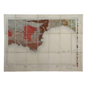
Geological Survey of England and Wales / Ordnance Survey – Sheet 22 – Dartmoor – 1908 – Folding Map
£95.00Geological Survey of England and Wales / Ordnance Survey
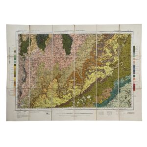
Geological Survey of England and Wales / Ordnance Survey – Sheet 15 – Warwick & Oxford – 1931 – Folding Map
£95.00Geological Survey of England and Wales / Ordnance Survey
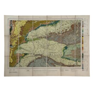
Geological Survey of England and Wales / Ordnance Survey – Sheet 19 – Berkshire, Wiltshire & Hampshire – 1939 – Folding Map
£95.00Geological Survey of England and Wales / Ordnance Survey
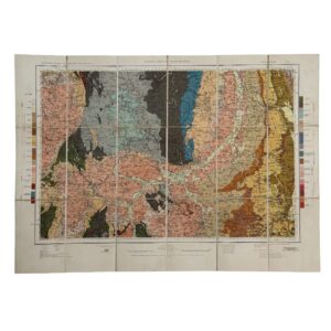
Geological Survey of England and Wales / Ordnance Survey – Sheet 11 – Derby & Charnwood – 1937 – Folding Map
£95.00Geological Survey of England and Wales / Ordnance Survey
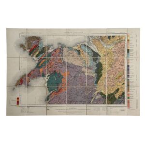
Geological Survey of England and Wales / Ordnance Survey – Sheets 9 & 10 – North Wales – 1930 – Folding Map
£95.00Geological Survey of England and Wales / Ordnance Survey
Geological Survey of England and Wales / Ordnance Survey – Sheet 3: Lake District – 1907 – Folding Map
£95.00Geological Survey of England and Wales / Ordnance Survey
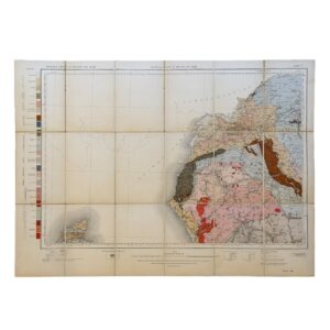
Geological Survey of England and Wales / Ordnance Survey – Solid Edition Sheet 8: Flamborough & Humber – 1935 – Folding Map
£75.00Geological Survey of England and Wales / Ordnance Survey
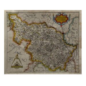
EBORACENSIS Comitatus Occidentalis vulgo WEST RIDING – c.1610-1637
£350.00Hole, William After Christopher Saxton
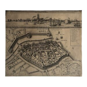
KYNGESTON UPON HULL – KINGSTON UPON HULL – THE SIEGE OF HULL – THE TOWNE OF HULL – c.1680-1890
£650.00Hollar, Wenceslaus
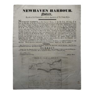
NEWHAVEN HARBOUR – NOTICE – By order of the Commissioners, with the Approbation of The Trinity House – 1814
£1,950.00Newhaven Harbour & The Commissioners, Trinity House


