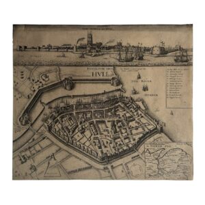
EBORACENSIS Comitatus Occidentalis vulgo WEST RIDING – c.1610-1637
Engraved map of the West Riding of Yorkshire after Christopher Saxton by William Hole.
Early seventeenth century: c.1610-1637.
Engraving with contemporary hand-colouring on laid paper.
Sheet size: 34.5 cm x 28.4 cm.
Blank verso.
Description:
A finely engraved and highly decorative early map of the West Riding of Yorkshire derived from the groundbreaking county surveys of Christopher Saxton, widely regarded as the father of English cartography. The map was engraved by the Scottish engraver William Hole and forms part of the important early seventeenth-century tradition of reinterpreting Saxton’s foundational surveys for a new generation of British atlases and geographical publications.
The map depicts the West Riding in dense topographical detail, recording towns, villages, rivers, forests, hills, bridges, and road networks across one of the most historically and economically important regions of northern England. York appears prominently towards the eastern side of the sheet, while the Pennine landscape and the western uplands are rendered with characteristic stylised hill forms. The boundaries of the Riding are accentuated with original hand-colouring, while the decorative strapwork title cartouche and compass ornament contribute to the strong visual appeal typical of the finest early Stuart cartography.
Christopher Saxton’s original county surveys, undertaken during the reign of Elizabeth I and first published in his atlas of 1579, represented the first systematic mapping project of England and Wales. They transformed the understanding of English geography and established the cartographic framework upon which many subsequent seventeenth-century mapmakers relied. William Hole’s engraved versions retain much of the authority and geographical structure of Saxton’s surveys while introducing a more ornamental engraved style associated with the Jacobean period.
The map is particularly significant for the historical geography of Yorkshire. The West Riding was one of the largest and most economically important administrative divisions in England, encompassing major centres of trade, agriculture, textile production, and regional administration. Long before the industrial expansion of the eighteenth and nineteenth centuries, the Riding already formed a crucial component of northern English economic life, and maps such as this provide an important visual record of the region prior to large-scale urban and industrial transformation.
Hole’s engraving is notable for its exceptionally dense nomenclature and elegant calligraphic engraving. The elaborate italicised directional lettering extending across the surrounding seas and neighbouring Ridings reflects the decorative cartographic conventions of the early seventeenth century. The engraving also preserves the strong visual balance between practical geographical information and ornamental design that characterises the finest British county maps of the period.
The verso displays visible show-through and offset from the printed surface together with evidence of historic central folding, consistent with inclusion in an early atlas or composite volume. The hand-colouring appears early and sympathetically executed, enhancing the regional boundaries and decorative elements without obscuring engraved detail.
Condition:
Edition not evident. Blank verso. Impression shows signs of wear to the plate but does not have the added ’48’ plate number to the bottom left-hand corner. Date: c.1610-1637. A strong impression with contemporary or near-contemporary hand-colouring. Historic central fold as issued. General age toning, light surface wear, and minor handling marks consistent with age. The engraving remains sharp and well defined, with clear, legible place names and attractive colour. A well-preserved example of an important early Yorkshire county map which is in very good condition overall.
A highly collectable early map of Yorkshire combining Saxton’s foundational cartography with William Hole’s refined Jacobean engraving style. Of considerable interest to collectors of British county maps, Yorkshire history, early English cartography, and seventeenth-century engraved maps.
Why buy from us?
At Hornseys, we are committed to offering items that meet the highest standards of quality and authenticity. Our collection is meticulously curated to ensure that each item is a valuable and authentic piece of history. Here’s what sets us apart:
- Authenticity and Provenance: Every item is researched, collated, and verified for authenticity.
- Expert Curation: Each item is selected with a keen eye for significance, condition, and rarity, ensuring a collection that is both diverse and distinguished.
- Customer Satisfaction: We strive to provide an exceptional customer experience, from detailed descriptions and provenance to secure and prompt delivery of your purchase.
- Returns Policy: We offer an unconditional guarantee on every item. If you wish to make a return, items may be sent back to us within fourteen days of receipt for any reason. We request advance notification of returns, and items must be returned in the same condition as sent for a full refund.
Explore Our Collection:
Visit Hornseys to explore our fine collection of rare and signed books, maps, artwork and objects. Whether you are an avid collector or looking for a special gift, our selection offers something truly unique. Located in the picturesque Yorkshire Dales, our Ripon gallery has been a haven for book lovers, art enthusiasts, and collectors since 1976.
Thank you for looking.