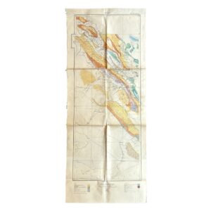
Persia. No. 9 H.E. 10.E – Geological Map Of South-West Iran Including The Masjid-I-Sulaiman And Haft Kel Oil Regions – 1929
Compiled by H. Cornes (Geological Office, London)
From surveys by the Geological Staff, Anglo-Persian Oil Company (A.P.O.C.)
Dated 1929
Colour-printed map on paper, 48.1 × 89.5 cm
A scarce and technically accomplished petroleum geological map of south-west Iran, produced for the Anglo-Persian Oil Company at a formative stage in the scientific development of Middle Eastern oil exploration. The sheet is clearly headed “Persia” and numbered “No. 9 H.E. 10.E”, forming part of a wider indexed series of geological survey sheets, as indicated by the printed grid diagram at lower centre.
The imprint confirms compilation by H. Cornes in London from fieldwork undertaken by the A.P.O.C. Geological Staff, and is explicitly dated 1929, placing it within the period of rapid expansion following the initial success of oil production at Masjid-i-Sulaiman and the subsequent identification of additional productive structures across the Zagros belt.
Description
The map presents a continuous geological section of the Zagros fold system, extending from the upland fold belts toward the lowlands adjoining the Persian Gulf. The terrain is rendered through a sophisticated system of colour-coded stratigraphy, corresponding to a detailed legend that includes:
- Alluvium and recent deposits
- Bakhtiari conglomerates
- Upper and lower Fars formations
- Lower Fars groups (subdivided)
- Asmari formation (noted as including parts of the Oligocene)
- Older Mesozoic and Palaeozoic units (in the extended legend)
These formations are arranged in elongated, parallel bands reflecting the anticlinal folding characteristic of the Zagros Mountains, with the structural interpretation reinforced by overprinted symbols indicating:
- Anticlinal and synclinal axes
- Faults and thrust faults
This structural emphasis confirms the map’s purpose as a working document for identifying petroleum-bearing anticlines, the principal targets of early oil exploration in the region.
Oilfield Content
The map incorporates detailed operational information directly related to oil exploration and production:
- Numerous oil wells, marked individually across the principal structures
- A clearly labelled oil pipeline traversing the southern sector toward export infrastructure
- Concentrated development in key producing areas, including:
- Masjid-i-Sulaiman (Maidan-i-Naftun)
- Haft Kel, shown with a dense cluster of wells and structural lines
The depiction of Haft Kel is particularly significant, showing it already established as a developed field by this date, with drilling aligned along mapped anticlines. This reflects the application of geological theory to practical exploration strategy and demonstrates the expansion of production beyond the original Masjid-i-Sulaiman discovery.
Cartographic Features
- Scale: 1 inch to 4 miles (1:253,440)
- Longitude referenced to Greenwich
- Gridded framework with marginal coordinates
- Index diagram indicating adjoining survey sheets
- Dual legends (primary stratigraphic and extended geological/structural) printed at the foot
The map’s elongated format reflects its function in representing a linear geological province, rather than a conventional rectangular territorial survey.
Physical Characteristics & Condition
Printed on paper and originally issued flat.
Observed condition:
- Multiple fold lines throughout, consistent with field or office use
- General creasing and handling wear
- Scattered spotting and areas of light staining
- Minor edge wear and small marginal imperfections
- Overall complete, with legends, imprint, and numbering intact
- In very good condition overall
The sheet remains structurally sound and fully legible, retaining strong clarity in both geological colouring and printed detail.
Function & Context
This map was produced as a technical instrument of petroleum exploration, not for general or commercial distribution. Its content and format indicate use by:
- Field geologists
- Survey teams
- Petroleum engineers
- Company planners engaged in exploration and infrastructure development
The integration of geological, structural, and operational data demonstrates a mature phase of exploration in which mapping, drilling, and transport planning were closely interlinked.
Historical Significance
The map documents a critical phase in the development of the Iranian oil industry:
- The transition from single-field exploitation to regional oilfield development
- The application of structural geology (anticline theory) to systematic exploration
- The consolidation of A.P.O.C.’s operations across the south-west Iranian oil belt
It provides a contemporaneous visual record of how geological understanding directly informed industrial expansion during the interwar period.
Rarity
Maps of this nature are infrequently encountered.
- Produced for internal or specialist use by A.P.O.C.
- Issued in relatively small numbers as part of a survey series
- Subject to heavy practical use, leading to low survival rates
- Large and fold-issued format contributes to fragility
As a result, surviving examples—particularly those retaining full legends and imprint—are scarce on the market.
Catalogue Summary
A scarce 1929 geological map of south-west Iran, compiled by H. Cornes for the Anglo-Persian Oil Company, depicting the folded structures of the Zagros petroleum province with detailed stratigraphy, structural axes, oil wells, and pipeline routes. Including both Masjid-i-Sulaiman and Haft Kel, it represents a key working document of early petroleum exploration and an important survival of interwar industrial geological cartography.
Location: HO: Drawer D: 003600
SHOP WITH CONFIDENCE AT HORNSEYS
At Hornseys, we are dedicated to offering items that uphold the highest standards of quality and authenticity. Our collection of artwork is carefully curated to ensure that each item we offer is authentic, collated, and complete.
Here’s what sets us apart:
- Authenticity and Provenance: Each map is researched and verified for authenticity.
- Expert Curation: We wholly own all our artworks. We trust our taste and have invested heavily in it. We have confidence in all artwork that we offer for sale.
- Customer Satisfaction: We strive to provide an exceptional customer experience, from detailed descriptions and provenance to secure and prompt delivery of your purchase.
- Returns Policy: We offer an unconditional guarantee on every item. If, however, you wish to make a return, artworks may be sent back to us within fourteen days of receipt for whatever reason. We request that we are notified in advance if you wish to do so. They must be returned to us in the same condition as they were sent for a full refund.
OUR COMMITMENT TO QUALITY AND SERVICE
Understanding the value and rarity of these items, we ensure that every aspect of your purchase meets the highest standards of quality and service. This includes:
- Free Expedited, Tracked, and Insured Delivery within the UK: Ensuring that your artwork arrives safely and promptly.
- Fully-Insured Worldwide Delivery: Offering peace of mind for international collectors with reliable and secure shipping options.
EXPLORE OUR COLLECTION
Visit Hornseys today to explore our fine collection of maps and other artworks. Whether you are an avid collector or looking for a special gift, our selection offers something truly unique. Located since 1976 in Ripon in the picturesque Yorkshire Dales, we are recognized as a destination gallery for tastefully curated artwork, rare maps, design, and fine books.