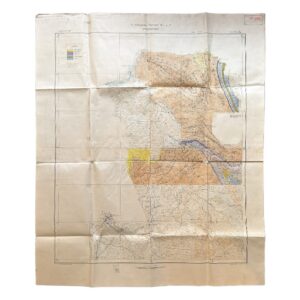
Persia. No. 9 H.E. 10.E – Geological Map Of South-West Iran Including The Masjid-I-Sulaiman And Haft Kel Oil Regions – 1929/35
Cornes, H & Anglo-Persian Oil Company (A.P.O.C.)
£950.00
Availability: In stock
Product Description
Persia. No. 9 H.E. 10.E – Geological Map Of South-West Iran Including The Masjid-I-Sulaiman And Haft Kel Oil Regions – 1929/35
Compiled by H. Cornes (Geol. Office, London)
From surveys by Geological Staff, A.P.O.C.
Published 1929, with additions from the Second aerial survey, 1935
Colour-printed map on paper, 115.9cm × 46.3cm
A rare and technically detailed petroleum geological map of south-west Iran, explicitly attributed on the sheet to the Geological Staff of the Anglo-Persian Oil Company (A.P.O.C.), and compiled in London by H. Cornes. The map is dated 1929 in the imprint, with a clearly printed red annotation “Second aerial survey 1935”, demonstrating that the sheet incorporates later revisions derived from aerial reconnaissance.
The map is headed “Persia” and numbered “No. 9 H.E. 10.E”, with an index diagram showing its position within a wider grid of adjoining survey sheets. The scale is given as 1 inch to 4 miles (1:253,440).
The sheet depicts a continuous section of the Zagros fold belt, running north-west to south-east and extending to the Persian Gulf. Geological colouring corresponds directly to the printed legend, which includes formations such as Bakhtiari conglomerates, Fars groups, and Asmari (including parts of the Oligocene)—the latter being a key oil-bearing formation. Structural features are explicitly marked, including anticlinal axes, synclinal axes, faults, and thrust faults, confirming the map’s function as a working geological document.
Oil-related information is clearly integrated. The legend includes symbols for oil wells and oil pipelines, both of which are plotted across the sheet. A labelled “Oil Pipeline” is visible in the southern portion, running toward the Gulf. Numerous well locations are marked as red dots, particularly concentrated in the Masjid-i-Sulaiman (Maidan-i-Naftun) and Haft Kel areas, confirming active or surveyed drilling sites at the time of compilation and revision.
The Haft Kel field is explicitly named and mapped with dense clustering of wells and structural lines. Its placement within a tightly folded anticline zone corresponds directly with the geological interpretation shown by coloured strata and structural axes, providing clear visual evidence of how anticline theory guided exploration. The map therefore documents not only the existence of the field but its geological rationale, illustrating the expansion of oil production beyond Masjid-i-Sulaiman into adjacent structures by the late 1920s.
Physical Description
Elongated vertical sheet, printed on paper, 115.9cm × 46.3cm, originally issued folded.
- Multi-colour geological printing corresponding to a detailed legend
- Black overprint for topography, settlements, rivers, and infrastructure
- Red overprint used selectively, including structural lines and the “Second aerial survey 1935” note
- Marginal coordinates with longitude referenced to Greenwich
- Lower margin with full legend (two sections), scale bar, and index to adjoining sheets
Condition (as evidenced):
- pronounced fold lines throughout
- creasing and handling wear
- scattered spotting and minor staining
- some edge wear and small marginal losses
- fully legible, with legends and imprint intact
- In very good condition overall
Cartographic & Geological Content
The map provides a fully integrated geological and operational view of the south-west Iranian oil zone:
- Masjid-i-Sulaiman (Maidan-i-Naftun) clearly labelled and structurally defined
- Haft Kel prominently shown with clustered wells and structural mapping
- Continuous folded belts of the Zagros system rendered in colour-coded stratigraphy
- Extensive plotting of anticlinal axes, demonstrating exploration targets
- Marked faults and thrust systems, indicating tectonic complexity
- Numerous named localities, rivers, and tracks, providing operational context
- Oil pipeline routes connecting inland fields toward export infrastructure
The geological legend confirms a stratigraphic framework ranging from Recent alluvium through Bakhtiari formations to older Mesozoic and Palaeozoic units, reflecting a sophisticated understanding of regional geology by this date.
Function & Production Context
All printed evidence indicates that this was a technical company map, produced for professional use:
- explicit attribution to A.P.O.C. Geological Staff
- inclusion of oil wells, pipelines, and structural axes
- use of detailed stratigraphic classification
- presence of an index to adjoining sheets, implying part of a larger survey series
The addition of the 1935 aerial survey demonstrates active revision and continued operational use, and places the map within the early adoption of aerial methods in petroleum geology.
Historical Significance
This sheet is a direct artefact of the interwar expansion of the Iranian oil industry. It captures:
- the transition from initial discovery (Masjid-i-Sulaiman) to multi-field development, including Haft Kel
- the application of anticlinal theory in systematic exploration
- the integration of aerial survey techniques into geological mapping by the mid-1930s
- the operational footprint of A.P.O.C. in one of the world’s most important oil provinces
It is therefore both a scientific document and an industrial record of early large-scale petroleum exploitation in Iran.
Rarity
Based on the evidence:
- produced by a corporate geological department rather than a commercial publisher
- highly technical in content
- part of a sectional survey series (as shown by the index diagram)
- large and fragile format intended for working use
Such maps are scarce survivals, particularly in complete form with legends and imprint present. The combination of 1929 base compilation and 1935 aerial revision further narrows comparable material.
Catalogue Summary
A scarce and technically important A.P.O.C. geological map of south-west Iran, compiled in 1929 by H. Cornes and revised using aerial survey in 1935. Depicting the folded structures of the Zagros oil province, with detailed plotting of wells, pipelines, and anticlines, and including both Masjid-i-Sulaiman and Haft Kel, it represents a working document of early petroleum exploration and a significant survival of interwar industrial geological cartography.
Location: HO: Drawer D: 003599
SHOP WITH CONFIDENCE AT HORNSEYS
At Hornseys, we are dedicated to offering items that uphold the highest standards of quality and authenticity. Our collection of artwork is carefully curated to ensure that each item we offer is authentic, collated, and complete.
Here’s what sets us apart:
- Authenticity and Provenance: Each map is researched and verified for authenticity.
- Expert Curation: We wholly own all our artworks. We trust our taste and have invested heavily in it. We have confidence in all artwork that we offer for sale.
- Customer Satisfaction: We strive to provide an exceptional customer experience, from detailed descriptions and provenance to secure and prompt delivery of your purchase.
- Returns Policy: We offer an unconditional guarantee on every item. If, however, you wish to make a return, artworks may be sent back to us within fourteen days of receipt for whatever reason. We request that we are notified in advance if you wish to do so. They must be returned to us in the same condition as they were sent for a full refund.
OUR COMMITMENT TO QUALITY AND SERVICE
Understanding the value and rarity of these items, we ensure that every aspect of your purchase meets the highest standards of quality and service. This includes:
- Free Expedited, Tracked, and Insured Delivery within the UK: Ensuring that your artwork arrives safely and promptly.
- Fully-Insured Worldwide Delivery: Offering peace of mind for international collectors with reliable and secure shipping options.
EXPLORE OUR COLLECTION
Visit Hornseys today to explore our fine collection of maps and other artworks. Whether you are an avid collector or looking for a special gift, our selection offers something truly unique. Located since 1976 in Ripon in the picturesque Yorkshire Dales, we are recognized as a destination gallery for tastefully curated artwork, rare maps, design, and fine books.
Related products


You may also like…

Iran – Persia – Masjid-i-Sulaiman Road Map – South-West Iran – Khuzestan Province – Masjid-i-Sulaiman Oilfield District – c.1949-54
£750.00Anglo-Iranian Oil Company (A.I.O.C.)
Iran – Persia – Qasr-i-Shirin Area. To Accompany Report M.H.L. 7 – Geological Map – 1929
£2,000.00Anglo-Persian Oil Company
Iran – Map Showing Proposed Journey By Geological Advisory Committee Of Anglo-Iranian Oil Co. Ltd., Autumn 1936
£1,800.00Geological Advisory Committee (Iran)
Andalucia Continens Sevillam Et Cordubam – Andalucia – Seville – Cordoba – Original Copper Engraved Map – 1642
£250.00Blaeu, Jan & Blaeu, Willem