Persia – A.P.O.C. Geological Map Of South-West Iran – Zagros Oilfields – Sheet No. 10 I & 10 J – 1929
Compiled by H. Cornes (Geol. Office, London)
From surveys by the Geological Staff, A.P.O.C.
1929
Colour-printed map on paper, scale 1 inch to 4 miles (1:253,440)
General Analysis
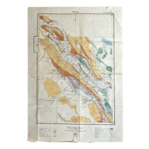
This is a substantial and technically ambitious petroleum-geological map produced for the Anglo-Persian Oil Company at an early and important stage in the geological investigation of south-west Iran. The sheet is clearly titled “Persia” and carries the sheet designation “No. 10 I & 10 J” at the upper margin. The lower imprint gives the compiler as H. Cornes, working from surveys by the Geological Staff, A.P.O.C., and is dated 1929. An index to adjoining sheets confirms that this was issued as part of a larger sectional survey series rather than as a standalone commercial map.
The map is not a general atlas sheet or administrative map. Its purpose is explicitly geological and oil-related. The legends identify stratigraphic units, structural symbols, and petroleum infrastructure, including anticlinal axes, synclinal axes, faults, thrust faults, oil wells, and oil pipelines. This places the map squarely within the working documentation of interwar petroleum exploration.
Geographic Scope
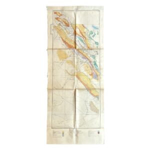
The area shown runs from the Persian Gulf coast inland across the folded structures of the Zagros Mountains. Coastal and near-coastal points visible on the sheet include:
- Bushire
- Ganaveh
- islands in the Gulf including Kharag
Further inland, the sheet clearly includes places such as:
- Behbehan
- Cham Zeidan
- Deh Dasht
- Kazerun
The inland geography is especially important. The map shows long, parallel geological belts running north-west to south-east, typical of the Zagros fold system, with settlement and route information overprinted across the geological base. This is precisely the kind of terrain in which A.P.O.C. geologists were identifying structures favourable for petroleum accumulation.
Geological Content
The two printed legends are especially revealing and allow a fairly precise characterisation of the map’s geological scope. The formations listed include:
- Alluvium
- Post Bakhtiaris (Conglomerates, etc.)
- Upper Bakhtiari
- Lower Bakhtiari
- Lower Bakhtiari & Upper Fars Undifferentiated
- Upper Fars
- Middle Fars
- Lower Fars Group III
- Lower Fars Group II
- Lower Fars Group I
- Lower Fars General
- Asmari (includes parts of Oligocene in places)
The continued legend then extends the sequence downward into older formations:
- Eocene (including parts of Cretaceous & Oligocene where undifferentiated)
- Cretaceous
- Pre-Aptian Mesozoics (General)
- Trias
- Permo-Carboniferous
- Cambrian (Hormuz Series, etc.)
This is a sophisticated petroleum stratigraphic scheme rather than a simplified geological colouring for general readers. In particular, the inclusion of Asmari, Fars and Bakhtiari units shows that the sheet was designed for direct use in oilfield interpretation. The geology is not merely decorative; it is being used to identify petroleum-bearing structures and regional stratigraphic relationships.
Structural Interpretation
The map places strong emphasis on structural geology. Multiple long and narrow bands of colour represent folded strata, and these are reinforced by lines showing:
- anticlinal axes
- synclinal axes
- faults
- thrust faults
This is exactly the visual language of early twentieth-century petroleum geology in Iran. The folded and faulted structures are the map’s organising principle, not political boundaries or transport routes. The dense concentration of mapped folds inland from the Gulf indicates that the sheet was intended to support the identification and correlation of oil-bearing anticlines across a large part of the south-west Iranian oil province.
Some areas are further marked with red and black linework and polygonal outlines that appear to record zones of particular geological or exploration interest. These overlays look contemporary to the map’s technical use and may represent field or office annotations related to structural interpretation, prospect boundaries, or drilling targets.
Petroleum Content
The second legend explicitly includes symbols for:
This is decisive evidence that the sheet served petroleum exploration and development rather than pure academic geology. The photographs show oil-related plotting and structural emphasis around areas such as Gach Qaranguli, Gach-i-Pokak, and other named structures. The combination of coloured stratigraphy, well symbols, and structural axes demonstrates that the map was part of A.P.O.C.’s practical exploration toolkit.
The use of a relatively small scale over a wide area suggests a regional synthesis map, likely intended to connect local oilfield investigations to broader geological understanding across adjoining structures and coastal export routes.
Production and Corporate Context
The imprint is important:
- Compiled by H. Cornes (Geol. Office, London)
- From Surveys by Geological Staff, A.P.O.C.
- 1929
This firmly places the map within the formal geological apparatus of the Anglo-Persian Oil Company. It is a corporate technical document, not a later derivative or educational simplification. The London Geological Office attribution suggests that field surveys carried out in Iran were being synthesised centrally into standardised printed working sheets.
The adjoining-sheet index confirms that the map belongs to an organised survey sequence. That makes it more desirable than an isolated manuscript sketch or local tracing, because it forms part of a coherent geological mapping programme by one of the foundational companies of the modern oil industry.
Physical Description and Condition
From the photographs, the map appears to be:
- printed on paper
- originally issued folded
- reinforced in places on the reverse and backed on linen
- now heavily worn from practical use
Visible condition points include:
- extensive fold lines throughout
- numerous creases and compressions from repeated handling
- edge fraying and small losses, especially at the margins
- several split folds and repaired separations
- scattered spotting, staining, and general age toning
- some old annotations in coloured pencil or red ink
- still substantially complete, with title, legends, imprint, and sheet number all present
This is plainly a working map rather than a pristine archive copy. Its condition is consistent with genuine field or office use within a geological or engineering context.
Historical Importance
This map is historically important on several levels.
First, it belongs to the early professional geological mapping of the south-west Iranian oil province, one of the most consequential petroleum regions in the world.
Second, it embodies the interwar period when petroleum geology in Iran was moving from local discovery into broader regional structural correlation. The map is not focused on one well or one field; it attempts to understand an entire belt of folded and potentially productive structures.
Third, it reflects the corporate-scientific methods of the Anglo-Persian Oil Company, whose survey and geological interpretation underpinned the expansion of British oil interests in Iran before nationalisation.
Finally, as a physical object, it is a strong example of how geological knowledge was actually handled: printed, folded, annotated, revised, and used.
Rarity
Material of this type is scarce.
Reasons include:
- it was produced for specialist internal or quasi-internal use
- it was part of a technical geological survey series rather than the public map trade
- survival rates are reduced by heavy working use
- large folded petroleum-geology sheets were especially vulnerable to splitting, discarding, and later separation from their series
A.P.O.C. geological maps do survive, but they are much less common than general maps of Persia or later state geological surveys. A sheet retaining its imprint, legends, sheet number, and broad legibility remains a desirable survival even in worn condition.
Location: HO: Drawer D: 003601
SHOP WITH CONFIDENCE AT HORNSEYS
At Hornseys, we are dedicated to offering items that uphold the highest standards of quality and authenticity. Our collection of artwork is carefully curated to ensure that each item we offer is authentic, collated, and complete.
Here’s what sets us apart:
- Authenticity and Provenance: Each map is researched and verified for authenticity.
- Expert Curation: We wholly own all our artworks. We trust our taste and have invested heavily in it. We have confidence in all artwork that we offer for sale.
- Customer Satisfaction: We strive to provide an exceptional customer experience, from detailed descriptions and provenance to secure and prompt delivery of your purchase.
- Returns Policy: We offer an unconditional guarantee on every item. If, however, you wish to make a return, artworks may be sent back to us within fourteen days of receipt for whatever reason. We request that we are notified in advance if you wish to do so. They must be returned to us in the same condition as they were sent for a full refund.
OUR COMMITMENT TO QUALITY AND SERVICE
Understanding the value and rarity of these items, we ensure that every aspect of your purchase meets the highest standards of quality and service. This includes:
- Free Expedited, Tracked, and Insured Delivery within the UK: Ensuring that your artwork arrives safely and promptly.
- Fully-Insured Worldwide Delivery: Offering peace of mind for international collectors with reliable and secure shipping options.
EXPLORE OUR COLLECTION
Visit Hornseys today to explore our fine collection of maps and other artworks. Whether you are an avid collector or looking for a special gift, our selection offers something truly unique. Located since 1976 in Ripon in the picturesque Yorkshire Dales, we are recognized as a destination gallery for tastefully curated artwork, rare maps, design, and fine books.