

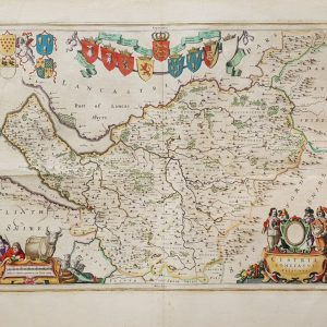
Bowen, Emanuel
£245.00
Out of stock
Original copper engraving. Map size: 70.2cm x 52.2cm. Edition not stated but c.1749-1760. Printed for I Tinney at the Golden Lyon in Fleetstreet, T Bowles in St Pauls Church Yard, John Bowles & Son in Cornhil and Robt Sayer In Fleet Street. Published in Emanuel Bowen’s ‘Large English Atlas’. Verso is blank but is numbered 23 in ink. Dated 1749 in the plate. Later, but not modern, attractive and detailed hand-colouring. Minor repairs to the verso with a 2cm split to base of the map. Very minor foxing but nice and clean. A very good indeed, bright, strong impression.


| Cookie | Duration | Description |
|---|---|---|
| cookielawinfo-checkbox-analytics | 11 months | This cookie is set by GDPR Cookie Consent plugin. The cookie is used to store the user consent for the cookies in the category "Analytics". |
| cookielawinfo-checkbox-functional | 11 months | The cookie is set by GDPR cookie consent to record the user consent for the cookies in the category "Functional". |
| cookielawinfo-checkbox-necessary | 11 months | This cookie is set by GDPR Cookie Consent plugin. The cookies is used to store the user consent for the cookies in the category "Necessary". |
| cookielawinfo-checkbox-others | 11 months | This cookie is set by GDPR Cookie Consent plugin. The cookie is used to store the user consent for the cookies in the category "Other. |
| cookielawinfo-checkbox-performance | 11 months | This cookie is set by GDPR Cookie Consent plugin. The cookie is used to store the user consent for the cookies in the category "Performance". |
| viewed_cookie_policy | 11 months | The cookie is set by the GDPR Cookie Consent plugin and is used to store whether or not user has consented to the use of cookies. It does not store any personal data. |