
PARTIE DE L’AMÉRIQUE SEPTENT? QUI COMPREND LA NOUVELLE FRANCE OU LE CANADA
De Vaugondy, Gilles Robert
£45.00
Availability: In stock
Product Description
PARTIE DE L’AMÉRIQUE SEPTENT? QUI COMPREND LA NOUVELLE FRANCE OU LE CANADA
Publisher: Gilles Robert De Vaugondy
Price: £45
Publication Date: 1755
Edition: Not stated
Format: Copper engraving
Condition: In good condition, unframed
Sheet Size: 69.4cm x 52.8cm
Condition:
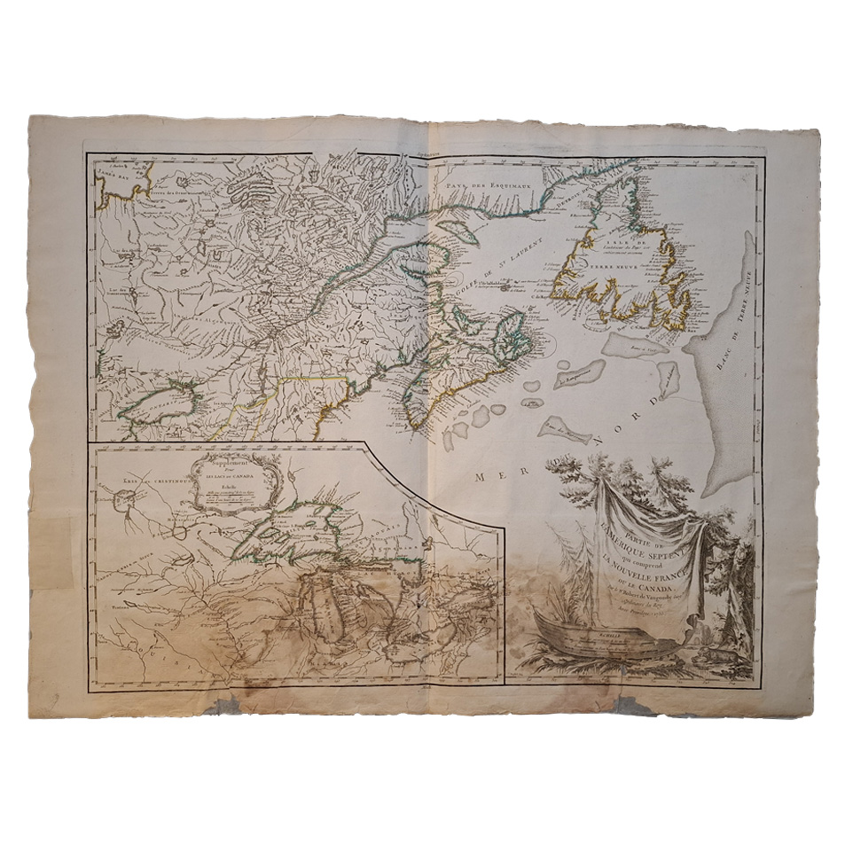
Original central fold line with original or very early hand-colouring. Age-spots. Age-toning to the paper and staining to the lower margin. Reverse is blank with age toning and marks. Professionally restored to the reverse to the lower margin which does affect the map. Repairs to the margins. A good only copy of this important map which was one of the first to use the current names of the five great lakes.
Location: Map Drawer C: FS: Folder M2000 002549
This detailed 18th-century map, crafted by the renowned French cartographer Gilles Robert de Vaugondy in 1755, provides a detailed representation of the northern regions of the Americas, specifically highlighting Nouvelle-France (New France) and the expansive territories of Canada during the period.
Key Features:
- Geographical Coverage:
- The map illustrates a vast expanse of North America, showcasing the prominent territories of Nouvelle-France, including parts of present-day Canada and the United States.
- The depiction of major rivers, such as the St. Lawrence and Mississippi, demonstrates their importance as transportation and trade routes during the era.
- The map includes Indigenous territories and settlements, reflecting the interactions between European colonists and Indigenous peoples.
- Cartographic Style:
- Engraved with intricate detail, the map features delicate hachures to depict relief and elevation.
- Coastal outlines are meticulously drawn, indicating harbours, bays, and significant maritime routes.
- The use of decorative cartouches adds an artistic element, with embellishments showcasing flora, fauna, and symbols of exploration.
- Historical Context:
- Created at a time when European powers vied for dominance in the Americas, the map reflects French claims to significant portions of North America prior to the Treaty of Paris in 1763.
- It serves as a testament to France’s ambition to establish a vast colonial empire, stretching from the Gulf of Mexico to the Arctic.
- Accuracy and Detail:
- Despite the limitations of 18th-century surveying techniques, Vaugondy’s map offers remarkable accuracy for its time, showcasing settlements, forts, and natural features with precision.
- The delineation of territories and regions reveals the evolving understanding of North American geography among European cartographers.
This map is not only a functional document of geographical knowledge but also a piece of historical art, reflecting the ambitions, perceptions, and cartographic expertise of 18th-century Europe.
Gilles Robert De Vaugondy: A Short Biography
Gilles Robert de Vaugondy (1688–1766) was a prominent French cartographer and geographer of the 18th century. Born in Paris, he was the grandson of the esteemed cartographer Nicolas Sanson, often regarded as the father of French cartography. This familial connection provided Gilles with access to a wealth of cartographic materials and knowledge, significantly influencing his career.
In 1730, Gilles inherited the cartographic firm of his uncle, Pierre Moullart-Sanson. He expanded the business by acquiring the stock of Hubert Jaillot, another leading French cartographer. This strategic move allowed him to update existing maps with new information, enhancing their accuracy without the need to create entirely new plates. His dedication to precision and detail earned him the title of Geographer to the King in 1730.
Gilles collaborated closely with his son, Didier Robert de Vaugondy (c.1723–1786), also a distinguished cartographer. Together, they produced the “Atlas Universel” in 1757, a monumental work that became one of the most important atlases of the 18th century. To compile this atlas, they integrated older sources with contemporary surveyed maps, verifying and correcting the latitude and longitude of many regions through astronomical observations. This meticulous approach ensured the inclusion of up-to-date information and numerous new place names.
The Vaugondys were known for their rigorous standards in mapmaking. They often subjected maps to astronomical readings to determine accurate latitude and longitude. Unlike many cartographers of their time, they took care to reference their sources, a practice that has greatly benefited the study of cartography’s history. Their maps and terrestrial globes were produced with high precision, employing a complex manufacturing process that involved several specialists.
Gilles often signed his maps as “M. Robert,” while Didier commonly used “Robert de Vaugondy,” sometimes adding “fils” or “filio” to denote his status as the son. This practice can make it challenging to attribute certain works definitively to either Gilles or Didier. Their combined efforts significantly advanced the field of cartography, leaving a lasting legacy in geographical sciences.
Gilles Robert de Vaugondy passed away in 1766, but his contributions, particularly the “Atlas Universel,” continue to be celebrated for their precision and artistry. The Vaugondys’ work exemplifies the Enlightenment era’s dedication to scientific accuracy and exploration.
SHOP WITH CONFIDENCE AT HORNSEYS
At Hornseys, we are dedicated to offering items that uphold the highest standards of quality and authenticity. Our collection of artwork is carefully curated to ensure that each item we offer is authentic, collated, and complete.
Here’s what sets us apart:
- Authenticity and Provenance: Each map is researched and verified for authenticity.
- Expert Curation: We wholly own all our artworks. We trust our taste and have invested heavily in it. We have confidence in all artwork that we offer for sale.
- Customer Satisfaction: We strive to provide an exceptional customer experience, from detailed descriptions and provenance to secure and prompt delivery of your purchase.
- Returns Policy: We offer an unconditional guarantee on every item. If, however, you wish to make a return, artworks may be sent back to us within fourteen days of receipt for whatever reason. We request that we are notified in advance if you wish to do so. They must be returned to us in the same condition as they were sent for a full refund.
OUR COMMITMENT TO QUALITY AND SERVICE
Understanding the value and rarity of these items, we ensure that every aspect of your purchase meets the highest standards of quality and service. This includes:
- Free Expedited, Tracked, and Insured Delivery within the UK: Ensuring that your artwork arrives safely and promptly.
- Fully-Insured Worldwide Delivery: Offering peace of mind for international collectors with reliable and secure shipping options.
EXPLORE OUR COLLECTION
Visit Hornseys today to explore our fine collection of maps and other artworks. Whether you are an avid collector or looking for a special gift, our selection offers something truly unique. Located since 1976 in Ripon in the picturesque Yorkshire Dales, we are recognised as a destination gallery for tastefully curated artwork, rare maps, design, and fine books.
Related products

Geologic Map of California Olaf P Jenkins Edition Los Angeles Sheet
£195.00Jennings, Charles W & Strand, Rudolph G
AN HIDROGRAPHICALL DRAUGHT OF MEXICO AS IT LIES IN ITS LAKES – ORIGINAL COPPER ENGRAVING
£150.00Gemelli Careri, Giovanni Francesco


You may also like…
(Gulf Of Mexico And The Caribbean) Carte Du Golphe Du Mexique Et Des Isles De L’Amerique
£185.00Bellin, Jacques Nicolas

