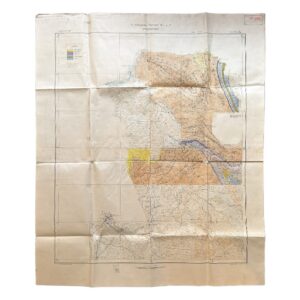
Iran – Persia – Masjid-i-Sulaiman Road Map – South-West Iran – Khuzestan Province – Masjid-i-Sulaiman Oilfield District – c.1949-54
Circa 1949–1954
Anglo-Iranian Oil Company (A.I.O.C.)
Large-format printed working map, approx. 99 × 66 cm
A rare and highly specialised mid-20th-century oilfield operations map, produced by the Anglo-Iranian Oil Company (A.I.O.C.) during the final phase of its direct control over Iranian petroleum infrastructure. The map documents in detail the road, survey, and industrial network of the Masjid-i-Sulaiman oilfield, the birthplace of the modern Middle Eastern oil industry following the 1908 discovery.
Created for operational use rather than public distribution, this sheet represents a transitional moment in both corporate and geopolitical history, immediately preceding the company’s reorganisation into British Petroleum in 1954.
Physical Description
Large sheet, printed on paper and issued for field use, measuring approximately 99 × 66 cm.
- Scale: 3 inches to 1 mile (approx. 1:21,120)
- Printing: three-colour linework
- Red: engineered road and service network
- Black: settlements, industrial structures, survey stations
- Blue/green: rivers, wadis, and drainage
Condition reflects practical field deployment:
- Original fold lines throughout
- Creasing, edge wear, and minor staining
- Hand-applied annotations in pencil, likely operational overlays
- In good, clean condition overall
Cartographic Content
The map provides detailed coverage of the Masjid-i-Sulaiman oilfield complex (Maidān-i-Naftūn), including:
- Oil wells and well clusters
- Tank farms and oil storage facilities
- Topping plant (refining/bitumen processing)
- Workshops and maintenance depots
- Water supply infrastructure
A dense network of engineered access roads links these installations, forming a functional transport system distinct from civilian mapping.
Also present is a comprehensive system of survey control points, identified by alphanumeric codes (e.g. C., B., S., N. series), indicating:
- Structured engineering survey grids
- Multiple survey teams or operational divisions
Hydrological features are carefully plotted, reflecting their importance in terrain assessment, infrastructure siting, and seasonal risk management within the Zagros foothill environment.
Function & Production Context
This is a working industrial map, produced for internal A.I.O.C. use.
Its primary functions would have included:
- Logistical planning across the oilfield
- Coordination of transport between wells, plants, and storage
- Engineering survey control and route alignment
- Road construction and maintenance operations
The imperial scale, drafting conventions, and systematic coding are characteristic of A.I.O.C. drawing office standards, rooted in British survey practice.
Historical Significance
The map relates directly to one of the most important sites in global industrial history:
- Masjid-i-Sulaiman, the first producing oilfield in the Middle East
- The operational heart of the Anglo-Persian / Anglo-Iranian Oil Company
By the early 1950s, the region stood at the centre of:
- Expanding global oil demand
- Major geopolitical tension surrounding Iranian oil nationalisation
This map therefore captures the physical infrastructure of extraction and distribution at a pivotal historical moment, just prior to the restructuring of the British-controlled oil system in Iran.
Rarity
Maps of this nature are exceptionally scarce.
- Produced in limited internal runs for A.I.O.C. personnel
- Not commercially issued or widely archived
- Typically subject to heavy use and low survival rates
Catalogue Summary
A scarce and historically significant Anglo-Iranian Oil Company operational road map, illustrating the infrastructure of the Masjid-i-Sulaiman oilfield during the early 1950s. Combining survey precision, industrial mapping, and logistical planning, it represents a rare survival of working petroleum cartography from a foundational period in the global oil industry.
Location: HO: Drawer D: 003598
SHOP WITH CONFIDENCE AT HORNSEYS
At Hornseys, we are dedicated to offering items that uphold the highest standards of quality and authenticity. Our collection of artwork is carefully curated to ensure that each item we offer is authentic, collated, and complete.
Here’s what sets us apart:
- Authenticity and Provenance: Each map is researched and verified for authenticity.
- Expert Curation: We wholly own all our artworks. We trust our taste and have invested heavily in it. We have confidence in all artwork that we offer for sale.
- Customer Satisfaction: We strive to provide an exceptional customer experience, from detailed descriptions and provenance to secure and prompt delivery of your purchase.
- Returns Policy: We offer an unconditional guarantee on every item. If, however, you wish to make a return, artworks may be sent back to us within fourteen days of receipt for whatever reason. We request that we are notified in advance if you wish to do so. They must be returned to us in the same condition as they were sent for a full refund.
OUR COMMITMENT TO QUALITY AND SERVICE
Understanding the value and rarity of these items, we ensure that every aspect of your purchase meets the highest standards of quality and service. This includes:
- Free Expedited, Tracked, and Insured Delivery within the UK: Ensuring that your artwork arrives safely and promptly.
- Fully-Insured Worldwide Delivery: Offering peace of mind for international collectors with reliable and secure shipping options.
EXPLORE OUR COLLECTION
Visit Hornseys today to explore our fine collection of maps and other artworks. Whether you are an avid collector or looking for a special gift, our selection offers something truly unique. Located since 1976 in Ripon in the picturesque Yorkshire Dales, we are recognized as a destination gallery for tastefully curated artwork, rare maps, design, and fine books.