Rand McNally And Co’s New Railway Guide Map Of The United States And Canada – 1875
Rand McNally And Co
£995.00
Availability: In stock
Product Description
Rand McNally And Co’s New Railway Guide Map Of The United States And Canada – 1875
Publisher: Rand McNally And Co
Place: Chicago, USA
Price: £995 including postage in the UK
Publication Date: January 12, 1875
Edition: Not stated
Sheet Size: 91.6cm x 44.2cm
Condition: Very good
Condition:
Original marbled paper covered boards with leather spine. Folded size: 11cm x 16.1cm. Sheet size: 91.6cm x 44.2cm. Engraved folding map with original colouring. Dated January 12, 1875. Map slightly creased and rubbed. Boards slightly creased and marked. In very good clean condition overall. Scarce.
Rand McNally And Co: A Brief Overview
Rand McNally & Company is one of the most influential cartographic and publishing firms in modern history. Founded in the United States in the mid-nineteenth century, it became synonymous with maps, atlases, and geographic education, shaping how generations of people understood space, travel, and the modern world. Its success rested on a combination of technical innovation, mass production, commercial insight, and cultural authority.
- Origins and Founding (1856–1868)
Early Beginnings
The company’s origins lie in Chicago, a rapidly expanding commercial and transport hub in the mid-nineteenth century. In 1856, William H. Rand, a skilled printer, entered into partnership with Andrew McNally, a Scottish-born engraver and bookbinder.
Initially, the firm operated as a job-printing and engraving business, producing:
- Tickets
- Timetables
- Commercial forms
- Small printed materials
Their proximity to railroads and publishing networks soon shaped the firm’s direction.
Shift Towards Cartography
During the 1860s, the explosive growth of the American railway system created unprecedented demand for:
- Accurate maps
- Railway guides
- Timetables for passengers and freight
Rand and McNally recognised this opportunity earlier than most competitors, pivoting decisively towards map production.
- Breakthrough: Railroad Maps and Guides
Railway Publishing
By the late 1860s, Rand McNally had become a leading publisher of railroad maps and guides, producing:
- Official railway timetables
- Passenger route maps
- Freight and logistics charts
These publications were practical tools rather than decorative objects, emphasising clarity, legibility, and reliability.
Mass Distribution
Railway stations, conductors, and travel agents became natural distribution points, allowing Rand McNally maps to circulate widely and rapidly. This embedded the firm’s name in everyday travel experience.
- Technological Innovation and Printing Excellence
Wax-Engraving Process
One of Rand McNally’s most important innovations was the adoption and refinement of wax engraving, a technique that:
- Allowed faster map production
- Reduced costs
- Enabled easier corrections and updates
This process gave the firm a decisive advantage in producing up-to-date maps in a period of rapid territorial and infrastructural change.
Colour Printing
Rand McNally was among the first American firms to master colour map printing at scale, using colour systematically to distinguish:
- Political boundaries
- Rail networks
- Topographical features
Colour became a hallmark of the brand’s visual authority.
- Expansion into Atlases and Educational Publishing
Atlases
In the late nineteenth century, Rand McNally expanded beyond transport mapping into full atlases, producing:
- World atlases
- National and regional atlases
- School atlases
These works were designed for:
- Accuracy
- Standardisation
- Broad public use
Unlike earlier elite atlases, Rand McNally’s products were affordable and widely accessible.
Educational Authority
The firm became deeply embedded in American education:
- Schools adopted Rand McNally atlases and wall maps
- Teachers relied on them as standard reference tools
- Generations of students learned geography through Rand McNally materials
This educational role gave the company lasting cultural authority.
- Rand McNally and the American Worldview
Mapping Expansion
Rand McNally’s rise coincided with:
- Westward expansion
- Industrialisation
- Urban growth
Its maps both reflected and reinforced a vision of:
- Territorial order
- Economic connectivity
- National coherence
The firm played a key role in normalising borders, routes, and spatial hierarchies in the American imagination.
Global Mapping
By the early twentieth century, Rand McNally was producing:
- Global maps
- International atlases
- Reference works used beyond the United States
Although rooted in an American perspective, its technical standards were internationally respected.
- Twentieth-Century Dominance
Automobile Age
The rise of the automobile transformed the company again.
Rand McNally became a leading producer of:
- Road atlases
- Highway maps
- Travel guides for motorists
Its road atlases, updated annually, became essential companions for drivers and families.
Corporate Growth
Throughout the twentieth century, Rand McNally diversified into:
- Encyclopaedic reference works
- Travel publications
- Educational materials
It maintained headquarters in Chicago, reinforcing its identity as a Midwestern industrial-intellectual institution.
- Brand Identity and Trust
Rand McNally achieved something rare: its name became synonymous with maps themselves.
Key elements of this trust included:
- Consistent accuracy
- Regular updating
- Clear design conventions
- Institutional relationships with schools, libraries, and transport bodies
For many users, a Rand McNally map was not one option among many, but the authoritative one.
- Challenges and Transformation (Late 20th–21st Century)
Digital Disruption
The late twentieth and early twenty-first centuries brought profound challenges:
- GPS navigation
- Digital mapping platforms
- Free, constantly updated online maps
These developments undermined the mass-market dominance of printed atlases.
Adaptation
Rand McNally responded by:
- Entering digital mapping
- Developing GPS devices
- Focusing on specialised markets such as commercial transport and education
The company underwent ownership changes and restructuring, reflecting wider upheaval in publishing.
- Legacy and Historical Significance
Rand McNally’s significance extends beyond its current commercial form.
Cartographic Legacy
The company:
- Standardised modern American cartography
- Popularised colour-coded mapping
- Bridged technical precision and mass accessibility
Cultural Impact
For over a century, Rand McNally shaped how people:
- Understood distance and direction
- Imagined national and global space
- Navigated daily life and long journeys
Its atlases and maps are now historical documents in their own right, capturing changing borders, transport systems, and geopolitical assumptions.
Conclusion
Rand McNally & Company stands as one of the most important cartographic institutions of the modern era. From its origins as a small Chicago printing partnership to its role as a global authority on maps and atlases, the firm exemplifies how technology, commerce, and knowledge production can combine to shape public understanding of the world.
Although digital mapping has transformed navigation, Rand McNally’s legacy endures in the standards it set, the trust it established, and the generations it taught to read the world through maps.
Why buy from us?
At Hornseys, we are committed to offering items that meet the highest standards of quality and authenticity. Our collection is meticulously curated to ensure that each item is a valuable and authentic piece of history. Here’s what sets us apart:
- Authenticity and Provenance: Every item is researched, collated, and verified for authenticity.
- Expert Curation: Each item is selected with a keen eye for significance, condition, and rarity, ensuring a collection that is both diverse and distinguished.
- Customer Satisfaction: We strive to provide an exceptional customer experience, from detailed descriptions and provenance to secure and prompt delivery of your purchase.
- Returns Policy: We offer an unconditional guarantee on every item. If you wish to make a return, items may be sent back to us within fourteen days of receipt for any reason. We request advance notification of returns, and items must be returned in the same condition as sent for a full refund.
Explore Our Collection:
Visit Hornseys to explore our fine collection of rare and signed books, maps, artwork and objects. Whether you are an avid collector or looking for a special gift, our selection offers something truly unique. Located in the picturesque Yorkshire Dales, our Ripon gallery has been a haven for book lovers, art enthusiasts, and collectors since 1976.
Thank you for looking.
Related products

Hausaland Or Fifteen Hundred Miles Through The Central Soudan Signed By The Author
£495.00Robinson, Charles Henry
South Col. One Man’s Adventure On The Ascent of Everest, 1953 Signed By Wilfrid Noyce
£295.00Noyce, Wilfrid


You may also like…
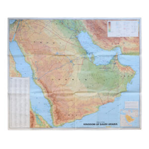
Saudi Arabia With City Maps Of Riyadh Jeddah And Dammam – Second Edition
£250.00GEOprojects Arab World Map Library