The World – The Persian Gulf – The Middle East – Egypt – Palestine – The Holy Land – Rdo. Dno. D. Adr. Stalpartio Abb. Togerlesi Disniso.d. Lumen Historiarum per Orientem
Ortelius, Abraham
£375.00
Availability: In stock
Product Description
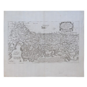
The World – The Persian Gulf – The Middle East – Egypt – Palestine – The Holy Land – Rdo. Dno. D. Adr. Stalpartio Abb. Togerlesi Disniso.d. Lumen Historiarum per Orientem
Cartographer: Ortelius, Abraham
Publisher: Fran. Hareio
Price: £375 including postage in the UK
Publication Date: 1624
Edition: Not stated
Sheet Size: 57.8cm x 45.8cm
Condition: Near fine
Condition:
Original copper engraved map. Not dated but 1624. Sheet size: 57cm x 45.8cm. A map of the Middle East from the Black Sea to the Persian Gulf from the ‘Parergon’, the last edition of 1624. Inset map of the World in an oval cartouche. Appears to show California as an island and notes the arrival of Columbus in 1492. Also includes an inset map of the Holy Land. A good, dark impression. Uncoloured and with some minor spotting and rust mark. Light toning to the edges of the paper, otherwise a near fine example. Scarce.
The Middle East In The Early 17th Century: A Brief Overview
The early seventeenth century (c. 1600–1650) was a formative period for the Middle East. It was marked by imperial rivalry, shifting borders, expanding global trade networks, and complex cultural and religious dynamics. Three major imperial powers dominated the region — the Ottoman Empire, the Safavid Empire, and the Mughal Empire on the eastern fringe — while a constellation of tribal, nomadic, and semi-autonomous polities shaped local affairs.
This period laid crucial groundwork for later political, economic, and cultural transformations across the region.
- Major Imperial Powers
- The Ottoman Empire
The Ottomans were at or near the zenith of their territorial reach. Their Middle Eastern dominions included:
- Anatolia
- The Levant (Syria, Lebanon, Palestine)
- Iraq (after intermittent wars with Persia)
- The Arabian Hijaz, including Mecca and Medina
- Egypt and parts of North Africa
Key Features of Ottoman Rule
- A centralised yet flexible administrative system, combining provincial governors with local notables.
- Control of pilgrimage routes and holy cities, enhancing the Sultan’s prestige as Custodian of the Two Holy Sanctuaries.
- An economy dominated by agricultural revenue and caravan trade.
Political Context
The early 1600s saw palace politics and periodic Janissary unrest, but the empire remained powerful and influential.
- The Safavid Empire (Persia)
Centred in modern-day Iran, the Safavid Empire was the Ottomans’ principal rival.
Characteristics
- Established Twelver Shi‘ism as the state religion, giving the empire a distinctive identity in contrast to its Sunni neighbours.
- Ruled from capitals such as Isfahan under Shahs including Shah Abbas I, whose reign brought military reform and cultural flourishing.
Relations with the Ottomans
- Frequent conflict over control of Iraq, the Caucasus, and eastern Anatolia.
- The Ottoman–Safavid Wars shaped the political geography of the Middle East for much of the century.
Economic and Cultural Life
- A thriving silk trade that attracted European merchants.
- Architectural and artistic achievements, especially under Abbas I.
- The Mughal Empire (peripheral influence)
Although primarily an Indian empire, the Mughals exerted cultural and economic influence in eastern Afghanistan and interacted with Persia and Central Asia.
Relevance to the Middle East
- Shared Persianate court culture, language and aesthetics.
- Diplomatic relations with the Safavids, sometimes tense over Kandahar.
- Contribution to regional trade networks that linked Persia, India, and the Arabian Peninsula.
- The Arabian Peninsula
The Arabian Peninsula in the early seventeenth century was a mosaic of tribes, coastal sheikhdoms, and spiritual centres.
The Hijaz
- Nominally under Ottoman rule, but local families and Sharifian authorities exercised considerable autonomy in Mecca and Medina.
- The pilgrimage economy linked the region to global Islamic networks from West Africa to Southeast Asia.
Central Arabia
- Dominated by tribal confederations and small oasis towns.
- No unified state; local leaders commanded influence through alliances and control of caravan routes.
Eastern Arabia
- Persian Gulf ports such as Qatif, Hofuf, and Bahrain were contested between Persian, Ottoman, and Portuguese forces.
- The Qasimi and various tribal maritime powers emerged later in the century as significant actors.
- North Africa and Egypt
Egypt
Under Ottoman rule but effectively governed by a powerful class of Mamluk beys, Egypt played a global role as:
- A major agricultural exporter (grain, sugar).
- A key link between the Mediterranean and the Red Sea.
- A pilgrimage staging point for the annual hajj caravans.
North Africa
Ottoman influence extended westwards through:
- Algiers, Tunis, and Tripoli, ruled by semi-autonomous regencies led by deys and pashas.
- Maritime corsair activity, which played a notable role in Mediterranean politics.
Morocco, under the Sa‘dian dynasty, remained independent and sometimes vied with the Ottomans for influence.
- The Eastern Mediterranean and Levant
Urban Centres
Cities such as Damascus, Aleppo, Jerusalem, Cairo, and Baghdad served as hubs of:
- Trade
- Scholarship
- Administration
- Pilgrimage
Trade Routes
The Levant was a meeting point for:
- Persian silk
- Indian textiles
- Arabian incense
- Ottoman and European merchant networks
European trading nations, particularly Venice, England, and the Dutch Republic, established capitulations (trade agreements) with the Ottoman Empire, securing privileges in return for commercial and diplomatic support.
- Iraq: A Zone of Imperial Contestation
Iraq was a major battleground between the Ottomans and Safavids.
Baghdad
Captured by the Ottomans in 1638 after long struggle, Baghdad was:
- A vital administrative centre
- A gateway between the Persian Gulf and the Levant
- A culturally vibrant city despite the instability
Mesopotamian Tribal Dynamics
Tribal confederations wielded considerable autonomy. Control of irrigation systems, river transport, and trade routes was shared among imperial officials and local leaders.
- The Persian Gulf and Maritime Rivalries
The early seventeenth century saw intense competition for control of sea routes.
Portuguese Influence
From the early 1500s the Portuguese controlled:
- Hormuz
- Key ports along the Arabian and Iranian coasts
Their dominance began to wane in the early 1600s.
Rise of English and Dutch Companies
The English East India Company and the Dutch VOC challenged Portuguese supremacy. They:
- Established trading factories
- Formed alliances with local rulers
- Engaged in naval conflict
The expulsion of the Portuguese from Hormuz in 1622, facilitated by a Safavid–English alliance, marked a major shift in regional power.
- Religious, Cultural, and Intellectual Life
Sunni–Shia Polarisation
Although cultural exchange persisted, the rivalry between Ottoman Sunnism and Safavid Shi‘ism created:
- Hardened religious identities
- Pilgrimage disruptions
- Political suspicion across imperial borders
Sufi Orders
Sufi brotherhoods, including the Naqshbandiyya, Qadiriyya and Mevleviyya, played vital roles in spiritual, educational, and social life.
Jewish and Christian Communities
Religiously diverse communities lived across the region:
- Sephardi Jews flourished in Ottoman cities such as Salonica, Istanbul, and Aleppo.
- Armenian, Greek, Maronite, Syriac, and Coptic Christian communities maintained local autonomy and long traditions of learning.
Cultural Production
The period saw:
- Architectural achievements, especially in Isfahan
- Manuscript production in Arabic, Persian, Turkish, Armenian and Hebrew
- Active intellectual exchange via trade routes and diplomatic missions
- Economy and Trade Networks
The Middle East was a crossroads of early modern global commerce.
Key Economic Sectors
- Agriculture in Egypt, Anatolia, and Mesopotamia
- Silk production in Persia and the Caucasus
- Caravan trade linking the Persian Gulf, Levant, and Red Sea
- Pilgrimage-related economies in Mecca and Medina
Global Connections
Trade linked the region to:
- Safavid Persia and Mughal India
- Venice, London, Amsterdam, and Marseilles
- Sub-Saharan Africa
- The emerging Atlantic world
The early seventeenth century marked the beginning of European commercial penetration, though political dominance would not emerge until the nineteenth century.
- Social and Demographic Landscape
The region was ethnically and linguistically diverse:
- Arabs, Turks, Persians, Kurds, Armenians, Jews, Berbers, Greeks, and South Asian merchant communities.
- Nomadic and semi-nomadic tribes played major roles in the Arabian Peninsula, Syria, and Iraq.
- Urban populations grew in cities shaped by trade, craft guilds, and religious institutions.
Social status was shaped by:
- Religion
- Political loyalty
- Tribal affiliation
- Urban or rural lifestyle
The period was dynamic rather than static, with frequent mobility across deserts, coasts, and imperial borders.
Conclusion
The early seventeenth-century Middle East was a region of imperial power, vibrant trade, cultural richness, and sharp political rivalries. The Ottomans and Safavids dominated the geopolitical landscape, while Arabian tribes, North African regencies, Gulf polities, and emerging European trading companies each shaped regional developments.
Key characteristics of the period include:
- Strong imperial structures but uneven local control
- Increasing global economic entanglement
- Intensified Sunni–Shia distinction
- Cultural flourishing in cities such as Isfahan, Aleppo, Cairo and Istanbul
- The gradual erosion of Portuguese maritime dominance
The world of the Middle East in this era was complex, multi-layered, and highly interconnected — a crucial precursor to the geopolitical transformations of the eighteenth and nineteenth centuries.
Why buy from us?
At Hornseys, we are committed to offering items that meet the highest standards of quality and authenticity. Our collection is meticulously curated to ensure that each item is a valuable and authentic piece of history. Here’s what sets us apart:
- Authenticity and Provenance: Every item is researched, collated, and verified for authenticity.
- Expert Curation: Each item is selected with a keen eye for significance, condition, and rarity, ensuring a collection that is both diverse and distinguished.
- Customer Satisfaction: We strive to provide an exceptional customer experience, from detailed descriptions and provenance to secure and prompt delivery of your purchase.
- Returns Policy: We offer an unconditional guarantee on every item. If you wish to make a return, items may be sent back to us within fourteen days of receipt for any reason. We request advance notification of returns, and items must be returned in the same condition as sent for a full refund.
Explore Our Collection:
Visit Hornseys to explore our fine collection of rare and signed books, maps, artwork and objects. Whether you are an avid collector or looking for a special gift, our selection offers something truly unique. Located in the picturesque Yorkshire Dales, our Ripon gallery has been a haven for book lovers, art enthusiasts, and collectors since 1976.
Thank you for looking.
Related products

(China And Korea) L’Empire De La Chine Pour Servir A L’Histoire Generale Des Voyages
£295.00Bellin, Jacques Nicolas


You may also like…
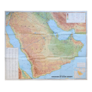
Saudi Arabia With City Maps Of Riyadh Jeddah And Dammam – Second Edition
£250.00GEOprojects Arab World Map Library