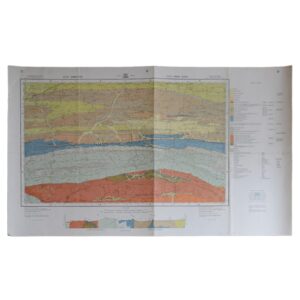
Department Of Mines – 3325D Port Elizabeth – 3326C Alexandria – 3326D Port Alfred – Geological Survey
Cartographer: Besaans, A. J
Publisher: Department Of Mines
Price: £65 (post-free in the UK)
Publication Date: 1962
Edition: 1st edition thus
Format: Colour printed lithograph
Condition: In very good condition
Sheet Size: 101.8cm x 74cm
Condition:
Sheet Size: 101.8cm x 74cm. Hanging holes to upper margin. Old fold lines. Backed on linen. Minor marks to the margins. Colouration very bright and clean. A very good copy.
Location: Pocket RSAGEOL: SR: 002873
The Geology Of Port Elizabeth, Alexandria And Port Alfred Districts: A Brief Overview
- Introduction and Geographic Context
The coastal districts of Port Elizabeth (now officially Gqeberha), Alexandria, and Port Alfred form part of the southeastern Cape region of South Africa, lying along the Indian Ocean margin of the Eastern Cape Province. The region straddles a geologically transitional zone between the Cape Fold Belt to the west, the Karoo Basin to the north, and the Mesozoic–Cenozoic coastal plains to the east.
The geology of the area reflects a long and dynamic history of sedimentation, tectonism, coastal erosion, and marine transgression, with notable sequences from the Palaeozoic to Quaternary.
- Cape Supergroup and the Southern Cape Fold Belt
The western portions of the region, particularly inland from Port Elizabeth and Alexandria, feature remnants of the Cape Fold Belt, formed during the late Palaeozoic (Permo-Carboniferous) collision of Gondwanan terranes.
Key lithostratigraphic components include:
- Table Mountain Group (TMS): Resistant quartzitic sandstones and subordinate shale layers, forming ridges and escarpments inland.
- Bokkeveld Group: More erodible shale-rich sequences representing deeper marine sedimentation.
- Structural features include tight folding, faulting, and thrusting, primarily aligned east–west, producing a rugged, dissected inland landscape.
These units were deposited in a shallow continental shelf setting and later deformed during the Cape Orogeny.
- Karoo Supergroup and Post-Orogenic Sedimentation
To the north and northeast of the districts, the Karoo Supergroup appears in patches, particularly as erosion-resistant mesas and low escarpments. Although not as extensive here as in the interior plateau, Karoo rocks play an important part in the local stratigraphy.
Units may include:
- Dwyka Group: Glacial diamictites, signifying the late Carboniferous ice age.
- Ecca Group: Black shales and mudstones, with thin coal seams in certain areas.
- Beaufort Group: Fluvial sandstones and mudstones, representing a semi-arid, terrestrial environment.
These units were deposited during the gradual filling of the Karoo foreland basin in response to mountain-building in the Cape Fold Belt.
- Uitenhage Group and Break-up of Gondwana
Perhaps the most geologically distinctive rocks in this region belong to the Uitenhage Group, deposited during the early to mid-Cretaceous, a time marked by the rift and break-up of Gondwana.
These units are widely exposed near Port Elizabeth and Alexandria, and consist of:
- Enon Formation: Red and brown conglomerates, indicative of high-energy alluvial fans and braided river systems. These are the most recognisable Cretaceous rocks in the region.
- Kirkwood and Sundays River formations: Interbedded sandstones, siltstones, and mudstones, deposited in riverine to deltaic and shallow marine environments. The Sundays River Formation is especially fossiliferous, preserving ammonites, bivalves, and marine reptiles.
These rocks reflect an evolving coastal plain during the opening of the South Atlantic Ocean, with alternating marine and non-marine conditions.
- Coastal Cenozoic Deposits and Marine Terraces
From Port Alfred to Port Elizabeth, the coastal geology is dominated by younger Cenozoic sediments, laid down during successive periods of marine transgression and regression.
These include:
- Calcarenites and aeolianites: Coastal limestone and cemented sand dunes (locally known as the Algoa Group) formed during Pleistocene high sea-level stands.
- Marine terraces and raised beaches, representing former coastlines shaped during warmer interglacial periods.
- Estuarine and dune sands: Common along modern estuaries and lagoons, such as those near the Bushman’s and Kowie Rivers.
These deposits are critical to understanding sea-level changes, coastal erosion, and Holocene climate evolution.
- Structural Geology and Tectonic Evolution
Structurally, the region reflects:
- Cape Fold Belt compressional deformation (east–west trending folds and faults)
- Cretaceous rift-related structures (normal faults and sediment-filled grabens in the Uitenhage Basin)
- Gentle Cenozoic uplift and warping, which has tilted former marine surfaces and influenced river incision patterns
The tectonic framework has a significant impact on drainage systems, coastal morphology, and the orientation of geological strata visible in road cuttings, cliffs, and quarries.
- Hydrogeology and Natural Resources
The region hosts a variety of aquifers:
- Fractured sandstones and shales of the Uitenhage and Cape Supergroups serve as secondary aquifers, with variable yields.
- Unconfined aquifers in coastal dunes provide potable water, particularly near Alexandria and Port Alfred.
- Karstic zones in calcarenites may yield significant groundwater, though they are vulnerable to contamination and salinity intrusion.
There are no major metallic mineral resources, but the region supports:
- Quarrying of sand, limestone, and clay
- Groundwater abstraction for agriculture and urban supply
- Palaeontological research in fossil-bearing sedimentary formations
- Environmental and Scientific Value
The region’s geology underpins its rich biodiversity and landscape diversity. It supports:
- Fynbos and coastal thicket ecosystems, which are sensitive to soil type and mineral content
- Estuarine habitats, influenced by sediment supply and tectonic subsidence
- Key scientific sites such as the Sundays River fossil beds and marine terraces used for climate research
The area is of particular interest to geologists, palaeontologists, and climate scientists, and it plays an increasing role in eco-tourism and heritage conservation.
Conclusion
The geology of the Port Elizabeth, Alexandria and Port Alfred districts reveals a multi-billion-year history of continental assembly, mountain-building, sedimentation, rifting, and coastal evolution. From the folded quartzites of the Cape Supergroup, through the rift sediments of the Uitenhage Group, to the dune systems and fossil-rich strata of the modern coast, the region offers a comprehensive view into southern Africa’s dynamic geological past.
Geology in this region is not only a scientific resource but a foundation for environmental management, water supply, land use planning, and cultural identity.
SHOP WITH CONFIDENCE AT HORNSEYS
At Hornseys, we are dedicated to offering items that uphold the highest standards of quality and authenticity. Our collection of artwork is carefully curated to ensure that each item we offer is authentic, collated, and complete.
Here’s what sets us apart:
- Authenticity and Provenance: Each map is researched and verified for authenticity.
- Expert Curation: We entirely own all our artworks. We trust our taste and have invested heavily in it. We have confidence in all artwork that we offer for sale.
- Customer Satisfaction: We strive to provide an exceptional customer experience, from detailed descriptions and provenance to secure and prompt delivery of your purchase.
- Returns Policy: We offer an unconditional guarantee on every item. If, however, you wish to make a return, artworks may be sent back to us within fourteen days of receipt for whatever reason. We request that we are notified in advance if you wish to do so. They must be returned to us in the same condition as they were sent for a full refund.
OUR COMMITMENT TO QUALITY AND SERVICE
Understanding the value and rarity of these items, we ensure that every aspect of your purchase meets the highest standards of quality and service. This includes:
- Free Expedited, Tracked, and Insured Delivery within the UK: Ensuring that your artwork arrives safely and promptly.
- Fully-Insured Worldwide Delivery: Offering peace of mind for international collectors with reliable and secure shipping options.
EXPLORE OUR COLLECTION
Visit Hornseys today to explore our fine collection of maps and other artworks. Whether you are an avid collector or looking for a special gift, our selection offers something truly unique. Located since 1976 in Ripon in the picturesque Yorkshire Dales, we are recognized as a destination gallery for tastefully curated artwork, rare maps, design, and fine books.