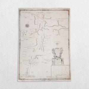
Cary’s Map Of The Country 12 Miles Round London – 1836
Author: Cary, G. & J.
Publisher: G. & J. Cary
Price: £125 including postage in the UK
Publication Date: 1836
Edition: Not stated
Sheet Size: 72.2cm x 59.2cm
Condition: Very good
Condition:
Date: 1836. Original steel engraving. Sheet size: 72.2cm x 59.2cm. Backed on linen. Original hand-colouring. A little creased but bright and clean. In very good condition overall.
G. & J. Cary: A Short Account
Overview
G & J Cary was the cartographic and publishing partnership of George Cary and his son John Cary, active from the late eighteenth century into the early nineteenth century. Together, they were among the most influential producers of practical, accurate, and commercially successful maps of Britain, particularly road maps and atlases that served travellers, administrators, and the expanding middle classes.
While earlier British cartography often emphasised decorative richness and symbolic authority, the Cary firm became synonymous with clarity, precision, and usability. Their work represents a decisive shift towards modern cartographic values and helped establish London as a centre of commercially oriented geographical publishing.
- George Cary (c.1730–1802): Foundations of the Firm
Early Life and Training
George Cary was born around 1730. His early life is not well documented, but by the mid-eighteenth century he was established in London as an engraver and map seller. He operated within the vibrant print culture of the capital, where maps were increasingly in demand for:
- Navigation and travel
- Estate management
- Education
- Government and commercial use
George Cary’s early work reflects the transition from artisanal engraving to systematic commercial map production.
Establishment in the Strand
By the 1760s, George Cary was trading from premises in the Strand, a location associated with booksellers, printmakers, and intellectual exchange. This situating placed Cary at the heart of Britain’s map trade.
His business activities included:
- Engraving maps
- Publishing new works
- Reissuing and updating existing cartographic material
From the outset, Cary’s focus was accuracy and legibility, rather than ornament.
- John Cary (c.1754–1835): The Cartographer Ascendant
Early Career and Collaboration
John Cary, born around 1754, was trained within his father’s business and quickly emerged as the firm’s intellectual and technical driving force. His abilities as a cartographer soon eclipsed those of many contemporaries.
By the 1780s, the firm increasingly operated under the joint imprint G & J Cary, signalling John’s growing role in map design, compilation, and revision.
Cartographic Philosophy
John Cary’s approach to mapping was marked by:
- Minimal decorative embellishment
- Emphasis on scale, projection, and accuracy
- Clear typography and consistent symbols
This represented a deliberate break with the elaborate styles of earlier mapmakers such as Speed or Blaeu. Cary maps were designed to be read and used, not merely displayed.
- The Road Maps and Itineraries
Landmark Road Atlases
The Cary firm is best known for its road maps and itineraries, which became standard references for late Georgian Britain. These works mapped:
- Turnpike roads
- Distances between towns
- Coaching routes and junctions
They were indispensable to:
- Commercial travellers
- Government officials
- Surveyors
- The coaching and postal services
The Cary road maps set new standards for reliability and coherence, often surpassing earlier guides in both accuracy and presentation.
National Integration through Mapping
By presenting Britain as a fully connected network of roads, G & J Cary’s publications reinforced the idea of a unified national space. Their maps made long-distance travel more predictable and contributed to the growing sense of Britain as an integrated economic and administrative entity.
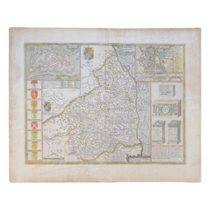
- County Maps and Atlases
County Surveys
In addition to road mapping, the Cary firm produced county maps of England, Wales, and Scotland, which were notable for:
- Careful revision of earlier surveys
- Consistent scale and format
- Absence of unnecessary ornament
These maps were widely used by landowners, professionals, and institutions.
Educational and General Atlases
John Cary also produced atlases intended for:
- Schools
- Private study
- Libraries
These works helped standardise geographical knowledge for a broader public and reflect Enlightenment values of order, classification, and rational design.
- Commercial Success and Reputation
Market Position
By the late eighteenth century, G & J Cary had become one of the leading cartographic firms in Britain. Their success rested on:
- Responsiveness to infrastructural change
- Regular updating of plates
- Reputation for trustworthiness
Their maps were often preferred over more decorative alternatives precisely because they were perceived as technically dependable.
Relationship to Contemporaries
The Cary firm operated alongside figures such as:
- William Faden
- Aaron Arrowsmith
- Later road-book publishers like Edward Mogg
In contrast to some rivals, Cary maps consistently prioritised domestic British geography, especially transport and administration.
- Later Years and the End of the Partnership
George Cary’s Death and Aftermath
George Cary died in 1802. After his death, John Cary continued to publish under his own name, though the reputation of G & J Cary remained closely associated with the firm’s earlier output.
John Cary’s Later Career
John Cary remained active into the early nineteenth century, continuing to revise and reissue maps as Britain’s transport network evolved. However, the rise of new mapping institutions and later technological advances gradually shifted the cartographic landscape.
John Cary died in 1835, marking the end of one of the most important private cartographic enterprises of the Georgian period.
- Historical Significance and Legacy
Cartographic Innovation
G & J Cary’s enduring importance lies in their:
- Commitment to accuracy and standardisation
- Rejection of decorative excess
- Integration of cartography with everyday use
They helped move British mapmaking towards a recognisably modern discipline.
Influence on Later Mapping
Their work influenced:
- Nineteenth-century commercial map publishers
- Government and institutional mapping practices
- The visual language of railway and administrative maps
Many later cartographers adopted Cary conventions of clarity, scale, and restraint.
Concluding Assessment
G & J Cary were not flamboyant innovators but quiet revolutionaries. By redefining what maps were for—and who they were for—they reshaped British cartography at a crucial moment in the nation’s development. Their maps made Britain intelligible as a practical, navigable space, supporting commerce, governance, and everyday mobility.
In doing so, the Cary firm stands as a bridge between the decorative traditions of early modern cartography and the functional, information-driven mapping of the modern age.
Why buy from us?
At Hornseys, we are committed to offering items that meet the highest standards of quality and authenticity. Our collection is meticulously curated to ensure that each item is a valuable and authentic piece of history. Here’s what sets us apart:
- Authenticity and Provenance: Every item is researched, collated, and verified for authenticity.
- Expert Curation: Each item is selected with a keen eye for significance, condition, and rarity, ensuring a collection that is both diverse and distinguished.
- Customer Satisfaction: We strive to provide an exceptional customer experience, from detailed descriptions and provenance to secure and prompt delivery of your purchase.
- Returns Policy: We offer an unconditional guarantee on every item. If you wish to make a return, items may be sent back to us within fourteen days of receipt for any reason. We request advance notification of returns, and items must be returned in the same condition as sent for a full refund.
Explore Our Collection:
Visit Hornseys to explore our fine collection of rare and signed books, maps, artwork and objects. Whether you are an avid collector or looking for a special gift, our selection offers something truly unique. Located in the picturesque Yorkshire Dales, our Ripon gallery has been a haven for book lovers, art enthusiasts, and collectors since 1976.
Thank you for looking.