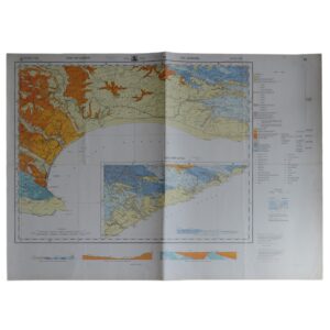
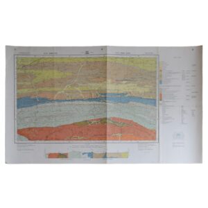
Department Of Mines – 3319C Worcester – 2419A Caledon – Geological Survey
Cartographer: Besaans, A. J
Publisher: Department Of Mines
Price: £65 (post-free in the UK)
Publication Date: 1966
Edition: 1st edition thus
Format: Colour printed lithograph
Condition: In very good condition
Sheet Size: 114.5cm x 84.2cm
Condition:
Sheet Size: 114.5cm x 84.2cm. Hanging holes to upper margin. Old fold lines. Backed on linen. Minor marks to the margins. Colouration very bright and clean. A very good copy.
Location: Pocket RSAGEOL: SR: 002874
The Geology Of Worcester And Caledon Districts: A Brief Overview
- Introduction and Regional Setting
The Worcester and Caledon districts, situated in the Western Cape Province of South Africa, lie within the core of the Cape Fold Belt, a structurally complex region shaped by Palaeozoic sedimentation and late Palaeozoic–early Mesozoic orogeny. These districts are bordered by the Hottentots-Holland, Hex River, Riviersonderend, and Langeberg Mountains, which are all underpinned by folded and faulted sedimentary rocks of the Cape Supergroup.
The region’s geology is significant not only for its dramatic scenery and historical wine-producing valleys but also for what it reveals about the tectonic assembly of southern Gondwana and the development of foreland fold-and-thrust belts.
- Geological Framework: The Cape Supergroup
The dominant lithostratigraphic unit in both districts is the Cape Supergroup, a succession of Palaeozoic marine and fluvial sedimentary rocks deposited from the Cambrian through to the Carboniferous, prior to and during the initial stages of the Gondwanide Orogeny.
- Table Mountain Group (TMG)
The oldest and most prominent unit, the Table Mountain Group, is chiefly composed of:
- Quartzitic sandstones (e.g. Peninsula and Skurweberg formations)
- Subordinate shales and mudstones
- Thick, resistant sequences forming towering cliffs and ridges
These sediments were laid down in high-energy, shallow marine to fluvial environments. The Bainskloof and Hex River Mountains, flanking Worcester, are classic examples of these sandstones, shaped by differential erosion.
- Bokkeveld Group
Overlying the TMG, the Bokkeveld Group comprises:
- Finer-grained shales, siltstones, and interbedded sandstones
- A more easily eroded lithology, forming the broad agricultural valleys, such as the Breede River Valley
The Bokkeveld represents deeper marine deposition, with sequences rich in Devonian marine fossils, particularly brachiopods and trilobites.
- Witteberg Group
The uppermost unit, the Witteberg Group, is transitional between marine and terrestrial environments. It includes:
- Well-bedded sandstones, often with ripple marks and cross-bedding
- Evidence of shallowing seas, coastal plain environments, and deltaic influences
Though less prominent than the TMG, the Witteberg Group is integral to understanding late Palaeozoic sea-level changes and the approach of continental collision.
- Tectonic History: The Cape Orogeny
The Cape Fold Belt was formed by the Gondwanide Orogeny, a major compressional event occurring roughly 270 to 220 million years ago. This tectonic phase resulted in:
- Tight, upright folds, aligned predominantly east–west
- Thrust faulting, including multiple nappes in the TMG
- The creation of synclinal valleys and anticlinal ridges
In both the Worcester and Caledon regions, the orogeny is recorded in spectacularly exposed structures such as:
- The north-verging fold belt near Worcester
- The duplex fault systems observed in the Riviersonderend Mountains
- The broad Worcester–Robertson syncline, containing younger sediments
These deformations indicate south-to-north crustal shortening, resulting from tectonic convergence along the southern Gondwanan margin.
- Post-Orogenic Developments and Surface Processes
After the orogeny, the region experienced significant erosion, uplift, and planation. Key geological developments include:
- The creation of broad valley floors over Bokkeveld shales, now sites of fertile agricultural land
- The exposure of resistant TMG quartzites in high ridges and escarpments
- The deposition of Cenozoic alluvium, colluvium, and terrace gravels, particularly in the Breede River floodplain
These post-orogenic processes shaped the modern landscape and influenced hydrology, soil formation, and land use patterns.
- Faulting and Seismicity
The region contains several significant post-folding fault systems, many of which are rejuvenated basement structures. Notable features include:
- The Worcester Fault Zone, which has been the site of historic seismic activity, including the 1969 Ceres–Tulbagh earthquake
- Minor strike-slip and oblique-slip faults, often associated with river alignment and spring locations
While currently regarded as moderately seismically active, these faults influence groundwater movement and can present engineering challenges for infrastructure and dam sites.
- Hydrogeology and Water Resources
Groundwater resources in the Worcester and Caledon districts are critical for irrigation, viticulture, and domestic supply. Key aquifer types include:
- Fractured quartzites of the TMG, which form deep but high-quality aquifers
- Weathered shales of the Bokkeveld Group, which host shallow, low-yield aquifers
- Alluvial aquifers in valley bottoms, particularly along the Breede and Sonderend rivers
The Table Mountain Group Aquifer System is one of the most important regional groundwater reserves in South Africa, valued for its clarity, yield, and long-term sustainability.
- Economic and Environmental Implications
While the region lacks large-scale mineralisation, geology influences:
- Agricultural land quality, especially where Bokkeveld shales weather into fertile soils
- Tourism and conservation, particularly around geological landmarks like Bainskloof Pass, Hex River Pass, and the Kogelberg Biosphere Reserve
- Viticulture, with soil and subsoil variations driven by underlying lithology shaping terroir
The region’s geology also supports environmental education, earth science research, and seismic monitoring.
Conclusion
The Worcester and Caledon districts form a geologically rich and structurally complex part of the Cape Fold Belt, shaped by the deposition of the Cape Supergroup and sculpted by the Gondwanide Orogeny. The folding, faulting, and erosion of these ancient rocks have created one of South Africa’s most scenic and agriculturally productive landscapes.
From the fossiliferous Bokkeveld shales to the towering quartzite ridges of the Table Mountain Group, the region offers a living archive of Palaeozoic environmental change, continental collision, and post-orogenic landscape evolution. Its geological heritage underpins not only its natural beauty but also its economic resilience, hydrological value, and scientific significance.
SHOP WITH CONFIDENCE AT HORNSEYS
At Hornseys, we are dedicated to offering items that uphold the highest standards of quality and authenticity. Our collection of artwork is carefully curated to ensure that each item we offer is authentic, collated, and complete.
Here’s what sets us apart:
- Authenticity and Provenance: Each map is researched and verified for authenticity.
- Expert Curation: We entirely own all our artworks. We trust our taste and have invested heavily in it. We have confidence in all artwork that we offer for sale.
- Customer Satisfaction: We strive to provide an exceptional customer experience, from detailed descriptions and provenance to secure and prompt delivery of your purchase.
- Returns Policy: We offer an unconditional guarantee on every item. If, however, you wish to make a return, artworks may be sent back to us within fourteen days of receipt for whatever reason. We request that we are notified in advance if you wish to do so. They must be returned to us in the same condition as they were sent for a full refund.
OUR COMMITMENT TO QUALITY AND SERVICE
Understanding the value and rarity of these items, we ensure that every aspect of your purchase meets the highest standards of quality and service. This includes:
- Free Expedited, Tracked, and Insured Delivery within the UK: Ensuring that your artwork arrives safely and promptly.
- Fully-Insured Worldwide Delivery: Offering peace of mind for international collectors with reliable and secure shipping options.
EXPLORE OUR COLLECTION
Visit Hornseys today to explore our fine collection of maps and other artworks. Whether you are an avid collector or looking for a special gift, our selection offers something truly unique. Located since 1976 in Ripon in the picturesque Yorkshire Dales, we are recognized as a destination gallery for tastefully curated artwork, rare maps, design, and fine books.