Kingston Upon Hull – Original Hand-Coloured Boundary Commission Ward Map of the Borough – c.1837
Original engraved and hand-coloured map. Sheet size 33.6 × 21.6 cm.
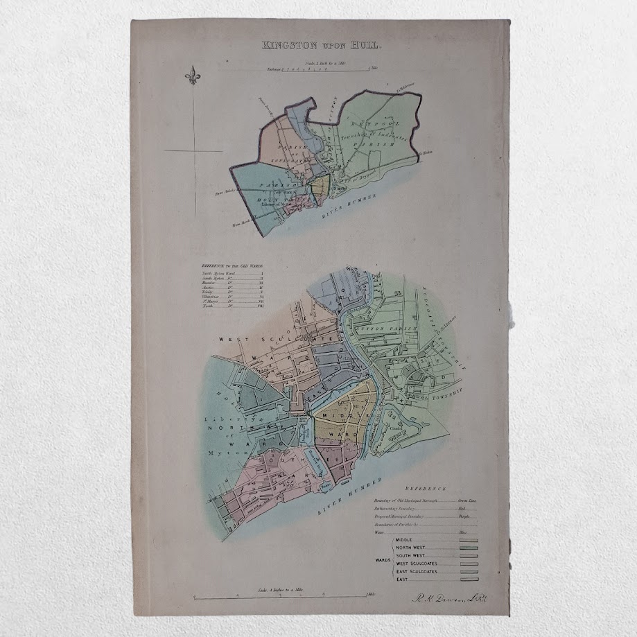
An attractive and historically important original hand-coloured map of Kingston upon Hull, drawn and engraved by R. K. Dawson and issued in 1837 in connection with the work of the Boundary Commissioners following the great programme of parliamentary and municipal reform undertaken in the first half of the nineteenth century.
The map depicts the borough divided into its newly constituted municipal wards, each carefully coloured by hand and identified in an accompanying key. The principal plan is supplemented by an inset map showing the wider extent of the borough and its relationship to the surrounding townships and the Humber estuary.
The wards represented include Middle Ward, North West Ward, South West Ward, West Sculcoates Ward, East Sculcoates Ward and East Ward. Boundaries of the parliamentary and municipal borough are identified, illustrating the administrative structure established following the reforms of the 1830s.
The period in which this map was produced was one of profound constitutional change. The parliamentary reforms of 1832 and the Municipal Corporations Act of 1835 transformed the political and civic organisation of many English boroughs. Hull, one of Britain’s most important ports, was among the towns whose electoral and municipal boundaries were carefully surveyed and recorded by the Commissioners. Maps such as the present example were essential administrative tools in implementing those reforms.
The map provides a valuable record of Hull immediately before the great dock expansions and urban growth of the Victorian period. Streets, waterways, docks, the River Hull and the Humber waterfront are all clearly delineated, offering a detailed picture of the borough at a pivotal moment in its history.
- K. Dawson’s maps are noted for their clarity and precision and remain important sources for historians of local government, electoral reform, genealogy and urban development. The present example combines decorative appeal with considerable historical significance as a document of early Victorian municipal administration.
A desirable and increasingly scarce item of Yorkshire cartography, electoral history and Hull topography.
Condition: Slight age-toning. Minor handling wear. Very good overall.
Location: Map Drawer D
Why buy from us?
At Hornseys, we are committed to offering items that meet the highest standards of quality and authenticity. Our collection is meticulously curated to ensure that each item is a valuable and authentic piece of history. Here’s what sets us apart:
- Authenticity and Provenance: Every item is researched, collated, and verified for authenticity.
- Expert Curation: Each item is selected with a keen eye for significance, condition, and rarity, ensuring a collection that is both diverse and distinguished.
- Customer Satisfaction: We strive to provide an exceptional customer experience, from detailed descriptions and provenance to secure and prompt delivery of your purchase.
- Returns Policy: We offer an unconditional guarantee on every item. If you wish to make a return, items may be sent back to us within fourteen days of receipt for any reason. We request advance notification of returns, and items must be returned in the same condition as sent for a full refund.
Explore Our Collection:
Visit Hornseys to explore our fine collection of rare and signed books, maps, artwork and objects. Whether you are an avid collector or looking for a special gift, our selection offers something truly unique. Located in the picturesque Yorkshire Dales, our Ripon gallery has been a haven for book lovers, art enthusiasts, and collectors since 1976.
Thank you for looking.