Aden – Second World War Military and Aeronautical Map of the Aden Protectorate, Yemen and Hadhramaut – 1945
Description
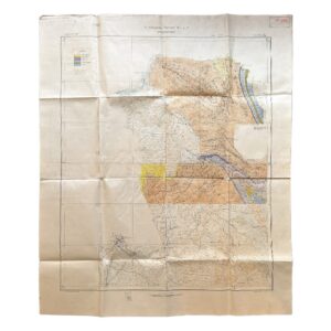
An important original Second World War military map of Aden and the south-western Arabian Peninsula, issued during the closing weeks of the war and incorporating detailed Royal Air Force aeronautical intelligence.
The sheet is titled Aden, with the formal reference 1:1,000,000 Asia Sheet North D-38 Aden, and is identified as the Fourth Edition, with Air Information. It was drawn, compiled and reproduced by 512 Field Survey Company, Royal Engineers, in July 1945.
At a scale of 1:1,000,000, the map covers an extensive and strategically important region centred upon the Gulf of Aden and the Bab-el-Mandeb. It includes much of present-day Yemen, the former Western and Eastern Aden Protectorates, the Hadhramaut, Aden Colony, Perim Island, the coast of French Somaliland and the approaches to the southern Red Sea.
Aden, Little Aden, Khormaksar, Sheikh Othman, Lahej, Taiz, Mocha, Hodeida, Djibouti and Perim are prominently marked, together with roads, tracks, caravan routes, settlements, wells, wadis, relief, communications and tribal or administrative divisions. The map preserves the intricate colonial and indigenous political geography of southern Arabia immediately before the post-war transformation of the region.
Particularly significant is the extensive red aeronautical overprint, based on information supplied by Headquarters, Royal Air Force, Middle East, in June 1945. Its reference key distinguishes:
- operational airfields;
- landing grounds;
- airfields whose precise location or continued existence had not been confirmed;
- infrequently used or unconfirmed landing grounds;
- abandoned airfields and landing grounds;
- seaplane stations and alighting areas;
- restricted flying areas;
- local magnetic variation.
The underlying cartography and accompanying compilation diagram document the varied sources from which the sheet was assembled. These include the East African provisional mapping of 1944, trigonometrical aerial photography dating from 1943, AAF Aero Chart No. 687, the third-edition GSGS Aden sheet and wartime communications intelligence.
The border diagram records the former division between Yemen, the Western Aden Protectorate, the Eastern Aden Protectorate, French Somaliland and Eritrea. The map therefore has relevance not only to military aviation and the Second World War, but also to the history of British colonial administration, the Royal Engineers, the RAF Middle East command, maritime communications and the political geography of Yemen and the Horn of Africa.
The Bab-el-Mandeb was one of the most strategically important maritime choke points in the British imperial communications system. Control and observation of Aden, Perim Island and the adjoining coast protected the route between the Indian Ocean, the Red Sea and the Suez Canal. This sheet combines conventional topographical mapping with operational air information at a moment when the region retained major importance to Allied transport, communications and defence.
Institutional reference: The Charles Hepworth Collection at the Middle East Centre Archive, St Antony’s College, Oxford, records a 1945 Fourth Edition of North D-38 Aden, produced by 512 Field Survey Company, Royal Engineers. The catalogue entry does not state whether that example carries the additional “With Air Information” aeronautical overprint found on the present sheet, so it cannot presently be confirmed as the same state or issue.
Condition
Good to very good condition for a large military field map of this date. The map retains its original machine folds and has not been laid down. There is moderate age-toning, scattered foxing and light surface marking, principally within the margins and lower reference area. Some folds show minor wear, creasing and short splits, with slight edge wear consistent with operational handling and storage. The printed map, aeronautical overprinting, reference keys and compilation details remain clear, complete and strongly coloured.
Please study the photographs carefully, as they form part of the description.
Cartographic and Historical Importance
This is a significant late-war operational map rather than a routine civilian geographical sheet. Its value lies in the combination of:
- detailed topographical mapping of southern Arabia;
- contemporary RAF airfield and landing-ground intelligence;
- Royal Engineers production;
- 1943 aerial-photographic sources;
- wartime communications intelligence;
- colonial and tribal boundaries predating modern Yemen;
- coverage of Aden, Perim Island and the Bab-el-Mandeb maritime corridor.
The July 1945 production date is particularly noteworthy. It records the military geography of the region at the end of the Second World War, after years of rapid wartime surveying, aerial reconnaissance and communications development.
Details
Title: Aden
Formal designation: Asia 1:1,000,000, Sheet North D-38
Edition: Fourth Edition, with Air Information
Cartographic authority: Geographical Section, General Staff / War Office
Production: 512 Field Survey Company, Royal Engineers
Air information: Headquarters, Royal Air Force, Middle East
Date: July 1945
Scale: 1:1,000,000
Size: 86.2 × 64 cm
Printing: Colour lithographic and aeronautical overprint on paper
Format: Original folding military map
Reference codes: M.D.R. 1/12252; E.A.F. 1643
Scarcity: A 1945 Fourth Edition of North D-38 Aden by 512 Field Survey Company, Royal Engineers is institutionally recorded at Oxford, but the catalogue does not specify the RAF air-information overprint present on this example. At the time of cataloguing we have been unable to locate another clearly identified copy of this precise Fourth Edition, “With Air Information” state currently offered commercially or recorded in an accessible institutional catalogue. This does not constitute a definitive census, but it suggests that the aeronautically overprinted state is particularly uncommon.
Location: HO: Drawer D: 003952
SHOP WITH CONFIDENCE AT HORNSEYS
At Hornseys, we are dedicated to offering items that uphold the highest standards of quality and authenticity. Our collection of artwork is carefully curated to ensure that each item we offer is authentic, collated, and complete.
Here’s what sets us apart:
- Authenticity and Provenance: Each map is researched and verified for authenticity.
- Expert Curation: We wholly own all our artworks. We trust our taste and have invested heavily in it. We have confidence in all artwork that we offer for sale.
- Customer Satisfaction: We strive to provide an exceptional customer experience, from detailed descriptions and provenance to secure and prompt delivery of your purchase.
- Returns Policy: We offer an unconditional guarantee on every item. If, however, you wish to make a return, artworks may be sent back to us within fourteen days of receipt for whatever reason. We request that we are notified in advance if you wish to do so. They must be returned to us in the same condition as they were sent for a full refund.
OUR COMMITMENT TO QUALITY AND SERVICE
Understanding the value and rarity of these items, we ensure that every aspect of your purchase meets the highest standards of quality and service. This includes:
- Free Expedited, Tracked, and Insured Delivery within the UK: Ensuring that your artwork arrives safely and promptly.
- Fully-Insured Worldwide Delivery: Offering peace of mind for international collectors with reliable and secure shipping options.
EXPLORE OUR COLLECTION
Visit Hornseys today to explore our fine collection of maps and other artworks. Whether you are an avid collector or looking for a special gift, our selection offers something truly unique. Located since 1976 in Ripon in the picturesque Yorkshire Dales, we are recognized as a destination gallery for tastefully curated artwork, rare maps, design, and fine books.