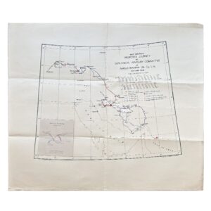
Tourist Plan Of Istanbul – c.1931 – Plan By Bay Ali Saim Ülgen
Colour-printed folding map of Istanbul (Constantinople), published for visitors and commercial promotion, [c. 1930s]
Dimensions: 56.4cm × 39.3 cm (sheet), folding into original printed card covers
Publisher: Mehmet Münim Eser
A highly attractive and informative interwar tourist map of Istanbul, issued at a moment when the newly modernised Republic of Turkey was actively promoting the city to international visitors. The map presents Istanbul as both an historic and contemporary metropolis, explicitly described on the cover as showing the “ancient and present city with Turkish and Byzantine monuments,” alongside transport infrastructure including railways, tramways, and ferry lines.
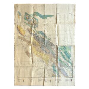
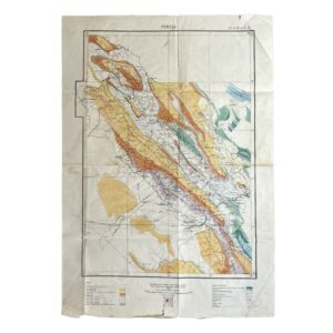
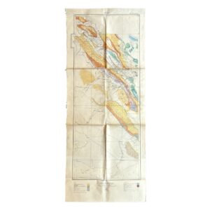
The plan is centred on the historic peninsula (Stamboul), with detailed coverage extending across the Golden Horn, Galata and Pera (Beyoğlu), and eastward over the Bosphorus to Üsküdar (Scutari) and Kadıköy (Chalcedon). The urban fabric is rendered in considerable detail, with streets, major buildings, and public monuments clearly delineated. Key sites—mosques, palaces, and administrative buildings—are highlighted in red, providing immediate visual orientation for the visitor. The map retains the dual nomenclature typical of the period, combining Ottoman, Turkish, and European place names (e.g. Constantinople / Istanbul; Scutari / Üsküdar), reflecting the transitional identity of the city in the early Republican era.
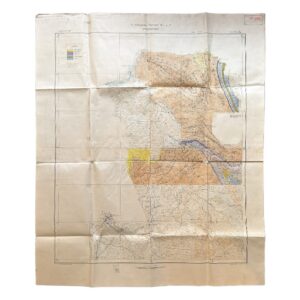
Transport is a central feature. The map carefully plots tram routes, railway lines, ferry crossings, and maritime approaches, including navigational lines across the Bosphorus and the Sea of Marmara. Insets include a regional map of Turkey showing motor routes to historic centres, and a smaller plan of the Princes’ Islands, reinforcing the publication’s function as a comprehensive tourist aid rather than a simple city plan.
The left-hand panel provides a detailed key and index, listing monuments, public buildings, transport hubs, and other points of interest. The design is clear, functional, and visually engaging, combining cartographic precision with a restrained but effective colour palette typical of high-quality European printing of the period.
The original printed covers add significant contextual interest. The verso carries a prominent advertisement for Türk Tütün Ltd. Şirketi, promoting Turkish tobacco products and giving a Galata address, alongside pricing in kuruş. This situates the map firmly within the commercial and promotional networks of early Republican Istanbul, where tourism, trade, and state monopolies intersected. Additional contemporary advertising panels within the covers further reinforce its role as a practical guide for travellers.
Physically, the map was issued folded for portability, and survives here with its original covers intact—an important point, as such ephemeral tourist maps were often heavily used and frequently discarded.
Condition:
Folding as issued into original printed card covers. General light to moderate wear consistent with use, including fold creases, slight edge wear, and minor toning. Covers a little rubbed and age-toned. Overall a very good plus clean, complete, and well-preserved example of a scarce and visually appealing interwar tourist map and guide.
Location: BR: 003601
SHOP WITH CONFIDENCE AT HORNSEYS
At Hornseys, we are dedicated to offering items that uphold the highest standards of quality and authenticity. Our collection of artwork is carefully curated to ensure that each item we offer is authentic, collated, and complete.
Here’s what sets us apart:
- Authenticity and Provenance: Each map is researched and verified for authenticity.
- Expert Curation: We wholly own all our artworks. We trust our taste and have invested heavily in it. We have confidence in all artwork that we offer for sale.
- Customer Satisfaction: We strive to provide an exceptional customer experience, from detailed descriptions and provenance to secure and prompt delivery of your purchase.
- Returns Policy: We offer an unconditional guarantee on every item. If, however, you wish to make a return, artworks may be sent back to us within fourteen days of receipt for whatever reason. We request that we are notified in advance if you wish to do so. They must be returned to us in the same condition as they were sent for a full refund.
OUR COMMITMENT TO QUALITY AND SERVICE
Understanding the value and rarity of these items, we ensure that every aspect of your purchase meets the highest standards of quality and service. This includes:
- Free Expedited, Tracked, and Insured Delivery within the UK: Ensuring that your artwork arrives safely and promptly.
- Fully-Insured Worldwide Delivery: Offering peace of mind for international collectors with reliable and secure shipping options.
EXPLORE OUR COLLECTION
Visit Hornseys today to explore our fine collection of maps and other artworks. Whether you are an avid collector or looking for a special gift, our selection offers something truly unique. Located since 1976 in Ripon in the picturesque Yorkshire Dales, we are recognized as a destination gallery for tastefully curated artwork, rare maps, design, and fine books.