-

R.T.M. – Rio Tinto Mining Company Limited – General Plan Of Works – c.1874-1876
£15,000.00Rio Tinto Mining Company Limited
-

This Trigonometrical Plan Of The Town And Port Of Liverpool Including The Environs Of Kirkdale Everton Low Hill & Toxteth Park From Actual Survey Is By Permission Most Respectfully Dedicated To The Worshipful Mayor And Common Council By Their Most Obedient And Obliged Humble Servant Michael Alexander Gage
£1,200.00Gage, Michael Alexander
-

SCOTIA REGNUM CUM INSULIS ADJACENTIBUS ROBERTUS GORDONIUS A STRALOCH DESCRIPSIT – ORIGINAL COPPER ENGRAVED MAP PUBLISHED BY JOAN BLAEU
£650.00Blaeu, Joan & Gordon, Robert
-

CARTE DES NOUVELLES DECOUVERTES AU NORD DE LA MER DU SUD TANT À L’EST DE LA SIBÉRIE ET DU KAMTCHATKA QU’À L’OUEST DE LA NOUVELLE FRANCE
£600.00Santini, François After De L’Isle, Joseph Nicholas and Buache, Philippe
-

-

-

Mediterranean Sea: Mappa Maris Mediterranei Fluxus Currentes Et Naturum Motionum Explicans
£350.00Kircher (Athanasius)
-

-

-

-

-

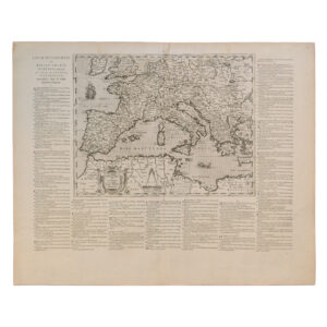
THEATRUM HISTORICUM AD ANNUM CHRISTI QUADRINGENTESIMUM IN QUO TUM IMPERII ROMANI TUM BARBARORUM CIRCUM INCOLENTIUM STATUS OB OCULOS PONITUR PARS OCCIDENTALIS
£300.00Guillaume (William) De Lisle & John Senex
-
-
-

-

-

-

-

Andalucia Continens Sevillam Et Cordubam – Andalucia – Seville – Cordoba – Original Copper Engraved Map – 1642
£250.00Blaeu, Jan & Blaeu, Willem
-

-

-

ISOLE DI MAJORCA D’IVICA E DI FORMENTERA DI NUOVA PROJEZIONE (BALEARIC ISLANDS)
£225.00Antonio Zatta
-

United Kingdom – Eire – Britiannicae Insulae In Quibus Albium Sieu Britannia Maior Ivernia Sieu Britannia Minor Tum Et Orcades, Ebudes, Cassiterides
£225.00Sanson, Nicolas & Tavernier, Melchior
-

-

-

CARTE GÉNÉRALE DE L’EMPIRE RUSSES EN EUROPE ET EN ASIE DRESSÉE D’APRÈS LES CARTES DE L’ATLAS RUSSIEN – PLATE 15 & PLATE 16
£195.00De Vaugondy, Gilles & Robert
-

-

(Scandinavia, Arctic ocean, Greenland, North Atlantic, Baffins Bay, Iceland, Canada) Carte Reduite Des Mers Du Nord
£195.00Bellin, Jaques Nicolas
-

(Iceland) Carte De L’Islande Pour Servir A La Continuation De L’Histoire Generale Des Voyages Dressee Sur Celle De M. Horrebows
£195.00Bellin, Jacques Nicolas
-

-

-

United Kingdom – Eire – Britiannicae Insulae In Quibus Albium Sieu Britannia Maior Ivernia Sieu Britannia Minor Tum Et Orcades, Ebudes, Cassiterides
£175.00Sanson, Nicolas & Tavernier, Melchior