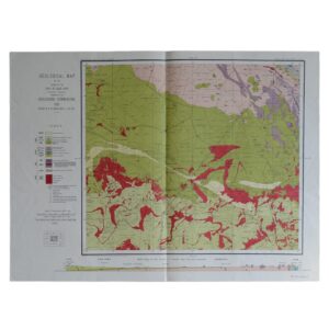
Geological Map Of The Colony Of The Cape Of Good Hope Sheet 13 – Beaufort West – Fraserburg
Cartographer: Rogers, A. W. & Schwarz, E. H. L
Publisher: The Geological Commission
Price: £95 (post-free in the UK)
Publication Date: 1911
Edition: 1st edition thus
Format: Lithograph
Condition: In very good condition
Sheet Size: 73.8cm x 57cm
Condition:
Lithograph. Sheet Size: 73.8cm x 57cm. Neat ink number to lower right margin. Old fold lines. Slightly creased, marked, dusty and rubbed with a closed tears to lower central fold line. Colouration very bright and clean. A good copy. Very scarce.
Location: Pocket RSAGEOL: SR: 002866
Geology Of The Beaufort West – Fraserburg Region: An Historical Overview
- Introduction and Geographic Setting
The Beaufort West – Fraserburg region, located in the Western and Northern Cape Provinces of South Africa, lies within the semi-arid heart of the Great Karoo. This area is geologically significant for its classic exposures of the Karoo Supergroup, especially the Beaufort Group, which has provided foundational insight into continental sedimentation, Permian–Triassic extinction events, and the evolution of early vertebrates.
Situated near the geographic centre of the Main Karoo Basin, the region is characterised by open plains, escarpments, and dolerite-capped mesas, sculpted over millions of years through erosion and tectonic quiescence.
- Geological Setting: The Main Karoo Basin
The Main Karoo Basin formed on the southern margin of the ancient Kaapvaal Craton during the late Palaeozoic to early Mesozoic, in response to orogenic loading from the Cape Fold Belt to the south. This retro-arc foreland basin filled with over 10 km of sedimentary rocks.
In the Beaufort West – Fraserburg area, the following Karoo Supergroup units are well represented:
- Ecca Group (locally restricted, deeper)
- Beaufort Group (dominant)
- Tarkastad Subgroup
- Overlying dolerite intrusions of the Karoo Large Igneous Province
These units record a transition from glacial and marine conditions to fluvial, lacustrine, and eventually volcanic environments.
- Beaufort Group: Fluvial Plains of the Late Permian
The Beaufort Group dominates the geology of this region. It is composed primarily of mudstone, siltstone, and fine-grained sandstone, deposited in meandering river systems with extensive floodplains.
Key Features:
- Sub-horizontal strata, typically gently southward-dipping
- Rich in vertebrate fossils, notably therapsids and early archosaurs
- Represents the post-glacial Pangaean interior, a seasonal, semi-arid landscape
The Beaufort sediments in this area are particularly associated with the Tropidostoma, Cistecephalus, and Dicynodon Assemblage Zones, all of which are critical for understanding Permian biodiversity and extinction dynamics.
- Permian–Triassic Extinction and the Upper Beaufort
Near the boundary between the Permian and Triassic periods, the Beaufort Group records one of the most profound biological turnovers in Earth’s history: the end-Permian mass extinction.
In the Fraserburg region, this event is preserved in:
- A shift from diverse therapsid fossils to a more homogenous vertebrate record
- An increase in mudstone content, possibly reflecting reduced sediment transport or climatic drying
- Changes in palaeosol horizons, suggesting altered weathering regimes and vegetation cover
The stratigraphy in this area is therefore not only sedimentologically instructive, but also palaeontologically critical.
- Tarkastad Subgroup and Early Triassic Environments
The uppermost part of the Beaufort Group, known as the Tarkastad Subgroup, is also present in places. It includes:
- Finer-grained sandstones and red mudstones
- Indicators of an increasingly arid climate with seasonal rivers
- Evidence for early dinosaurs and archosaurian reptiles
This transitional sequence provides insight into post-extinction recovery ecosystems and the start of Triassic faunal dominance.
- Dolerite Intrusions: Karoo Volcanism
During the early Jurassic, the region experienced widespread magmatic activity as part of the Karoo Large Igneous Province. This resulted in the intrusion of:
- Dolerite sills and dykes, often visible as prominent ridges or table mountains
- These intrusions caused contact metamorphism, altering nearby mudstones into hornfels
- Structural features such as jointing and radial dykes around major centres can also be mapped
Dolerite bodies now dominate the higher topography, forming landscape-defining escarpments and koppies.
- Surface Processes and Recent Cover
Modern surface features in the region result from millions of years of erosion, coupled with episodic weathering and soil formation.
- Calcareous soils and calcretes cap some pediments
- Colluvial and alluvial fans form along valley margins
- Thin, wind-blown sands occur in low-lying pans and dry riverbeds
These surficial deposits reflect semi-arid climatic conditions and play a major role in determining land use suitability.
- Hydrogeology and Water Resources
Groundwater is a critical resource in this water-scarce region. It is found primarily in:
- Fractured sandstone aquifers
- Weathered dolerite contacts
- Alluvial deposits along ephemeral rivers such as the Gamka and Dwyka
Water quality can be variable, with high salinity and fluoride in some boreholes, requiring treatment or selective abstraction.
- Palaeontological and Scientific Significance
This region is internationally recognised for its abundant vertebrate fossils, which have been vital in establishing:
- The biozonation of the Beaufort Group
- The global record of the end-Permian extinction
- The evolution of mammal-like reptiles and the rise of the archosaurs
Fraserburg hosts a small fossil museum, and the area is frequently visited by geological field parties and academic researchers.
- Economic Geology and Land Use
Although not a major mining area, the region’s geology shapes local economics:
- Building stone and gravel from dolerite and sandstone
- Potential for uranium or gas in deeper Karoo shales (not currently exploited here)
- Livestock farming is the primary economic activity, dependent on soil quality, water supply, and terrain, all geologically determined
The interplay of geology, climate, and topography defines land capability in this sensitive, semi-arid zone.
Conclusion
The Beaufort West – Fraserburg region represents one of the world’s most complete and accessible records of late Palaeozoic to early Mesozoic continental evolution. Its layered geological history — from Permian floodplains and extinction events to Jurassic magmatism — is preserved across a stark and beautiful landscape shaped by deep time.
This region continues to serve as a cornerstone of South African geoscience, offering insights into Earth’s past climates, biotas, and tectonic cycles — and sustaining local communities through the enduring resources of its geological foundation.
SHOP WITH CONFIDENCE AT HORNSEYS
At Hornseys, we are dedicated to offering items that uphold the highest standards of quality and authenticity. Our collection of artwork is carefully curated to ensure that each item we offer is authentic, collated, and complete.
Here’s what sets us apart:
- Authenticity and Provenance: Each map is researched and verified for authenticity.
- Expert Curation: We entirely own all our artworks. We trust our taste and have invested heavily in it. We have confidence in all artwork that we offer for sale.
- Customer Satisfaction: We strive to provide an exceptional customer experience, from detailed descriptions and provenance to secure and prompt delivery of your purchase.
- Returns Policy: We offer an unconditional guarantee on every item. If, however, you wish to make a return, artworks may be sent back to us within fourteen days of receipt for whatever reason. We request that we are notified in advance if you wish to do so. They must be returned to us in the same condition as they were sent for a full refund.
OUR COMMITMENT TO QUALITY AND SERVICE
Understanding the value and rarity of these items, we ensure that every aspect of your purchase meets the highest standards of quality and service. This includes:
- Free Expedited, Tracked, and Insured Delivery within the UK: Ensuring that your artwork arrives safely and promptly.
- Fully-Insured Worldwide Delivery: Offering peace of mind for international collectors with reliable and secure shipping options.
EXPLORE OUR COLLECTION
Visit Hornseys today to explore our fine collection of maps and other artworks. Whether you are an avid collector or looking for a special gift, our selection offers something truly unique. Located since 1976 in Ripon in the picturesque Yorkshire Dales, we are recognized as a destination gallery for tastefully curated artwork, rare maps, design, and fine books.