-

Africa Maps108 Products
-
Antarctic Maps5 Products
-
Asia Maps81 Products
-
Celestial Maps2 Products
-
Europe Maps121 Products
-
Folding Maps68 Products
-
Geological Maps53 Products
-
Military Maps6 Products
-
North America Maps21 Products
-
Oceania Maps23 Products
-
South America Maps22 Products
-
United Kingdom County Maps51 Products
-
World Maps9 Products
-
Yorkshire Maps4 Products
Karachi Guide Map – Season 1926-7 – Published Under The Direction Of Brigadier R H Thomas – Surveyor General Of India 1929
£1,750.00Thomas, Brigadier R. H.
Astronomie Populaire Ou Description Des Corps Célestes Avec Atlas En Tableaux Transparents
£1,250.00Librarie Kiessling & Cie & P. Imbreghts
Geological Maps Columns And Sections Of The High Zagros Of South-West Iran
£1,250.00The British Petroleum Company Limited
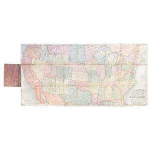
Rand McNally And Co’s New Railway Guide Map Of The United States And Canada – 1875
£995.00Rand McNally And Co
Peshawar Guide Map – Pakistan – Published Under The Direction Of Brigadier H J Couchman – Surveyor General Of India 1935
£950.00Couchman, Brigadier H. J.
Tectonic Map Of Australia – First Edition – Map On Four Sheets
£650.00Bureau of Mineral Resources, Geology and Geophysics
SCOTIA REGNUM CUM INSULIS ADJACENTIBUS ROBERTUS GORDONIUS A STRALOCH DESCRIPSIT – ORIGINAL COPPER ENGRAVED MAP PUBLISHED BY JOAN BLAEU
£650.00Blaeu, Joan & Gordon, Robert
CARTE DES NOUVELLES DECOUVERTES AU NORD DE LA MER DU SUD TANT À L’EST DE LA SIBÉRIE ET DU KAMTCHATKA QU’À L’OUEST DE LA NOUVELLE FRANCE
£600.00Santini, François After De L’Isle, Joseph Nicholas and Buache, Philippe
Jaipur Guide Map – 1971 – Published Under The Direction Of Brigadier J. S. Paintal – Surveyor General Of India
£500.00Paintal, Brigadier J. S.
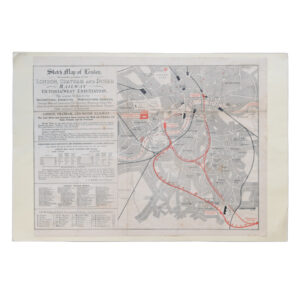
Sketch Map Of London Shewing The Position Of The London Chatham And Dover Railway Victoria (West-End) Station
£495.00The London Chatham And Dover Railway
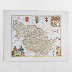
Yorkshire – Ducatus Eboracensis Pars Occidentalis – The West Riding Of Yorke Shire
£495.00Valk, Gerard & Schenk, P
Geological Map Of Israel – Revised Edition – 1976 – Map On Two Sheets
£450.00Picard, L. Y, Golani, U, Bentor, Y. K, Vroman, A & Zak, I
Delhi Guide Map – 1969 – Published Under The Direction Of Brigadier Jamshed Dalal – Surveyor General Of India
£400.00Dalal, Brigadier Jamshed
MAP OF THE MADRAS PRESIDENCY SHOWING ROADS AND DISTANCES – 1929
£400.00Central Survey Office, Madras