Ordnance Survey / Lt. Colonel Hall – Yorkshire – Sheet 216 – Bradford – First Edition – Folding Map – 1852
Southampton: Ordnance Map Office, 1852.
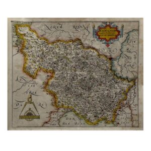
First published edition. Large and highly detailed mid-nineteenth-century Ordnance Survey map of Bradford and the surrounding West Riding district, issued by Lt. Colonel Hall at the Ordnance Map Office, Southampton, in 1852. Original hand-colouring. Dissected onto linen by Edward Stanford Ltd. and preserved in its original slipcase.
An important and visually striking early Ordnance Survey sheet centred on Bradford during the city’s rapid industrial expansion. The map encompasses Bradford, Manningham, Horton, Bowling, Little Horton, North Bierley and neighbouring districts, together with wider coverage extending towards Queensbury, Thornton, Wilsden, Shipley, Calverley, Ovenden and Halifax. Roads, lanes, field systems, township boundaries, railways, mills, quarries, collieries, waterways and individual buildings are all rendered with the remarkable precision and clarity that established the reputation of the Ordnance Survey in the Victorian period.
The map captures the transformation of Bradford into one of Britain’s major textile and manufacturing centres, documenting both the expanding urban environment and the surrounding agricultural landscape. Industrial features are carefully delineated alongside turnpikes, early railway infrastructure and densely plotted settlement patterns, making the sheet particularly valuable for local history, industrial archaeology, genealogy and the study of nineteenth-century urban growth.
Issued in dissected form for practical use, the map folds neatly into the original Edward Stanford slipcase, a format intended for surveyors, engineers, estate managers and commercial travellers. Survival rates for large-format working Ordnance Survey maps of this period are relatively low, especially examples retaining original hand-colouring and contemporary Stanford housing.
Sheet size: 98.2 x 65.9 cm.
Condition: Very good plus overall. Map dissected onto linen as issued, with light age toning, minor handling wear and minor wear at fold intersections consistent with use. Original Stanford slipcase slightly worn but sound, retaining printed label and contemporary ownership inscription. A very nice copy indeed.
Why buy from us?
At Hornseys, we are committed to offering items that meet the highest standards of quality and authenticity. Our collection is meticulously curated to ensure that each item is a valuable and authentic piece of history. Here’s what sets us apart:
- Authenticity and Provenance: Every item is researched, collated, and verified for authenticity.
- Expert Curation: Each item is selected with a keen eye for significance, condition, and rarity, ensuring a collection that is both diverse and distinguished.
- Customer Satisfaction: We strive to provide an exceptional customer experience, from detailed descriptions and provenance to secure and prompt delivery of your purchase.
- Returns Policy: We offer an unconditional guarantee on every item. If you wish to make a return, items may be sent back to us within fourteen days of receipt for any reason. We request advance notification of returns, and items must be returned in the same condition as sent for a full refund.
Explore Our Collection:
Visit Hornseys to explore our fine collection of rare and signed books, maps, artwork and objects. Whether you are an avid collector or looking for a special gift, our selection offers something truly unique. Located in the picturesque Yorkshire Dales, our Ripon gallery has been a haven for book lovers, art enthusiasts, and collectors since 1976.
Thank you for looking.