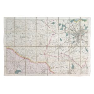
ORDNANCE SURVEY YORKSHIRE SHEET SE 27 NW. GREWELTHORPE, HACKFALL WOOD AND THE SWINTON ESTATE – PROVISIONAL EDITION – 1956
Published by the Director General of the Ordnance Survey, Chessington, Surrey, 1956.
Large folding map. Scale 1:10,560 (6 inches to 1 mile).
Sheet SE 27 NW.
67 x 55.8 cm.
Slight creasing. Near fine condition. A bright, clean and attractive example.
Description
An exceptionally detailed mid-twentieth-century Ordnance Survey map centred upon Grewelthorpe, Hackfall Wood, and the historic Swinton Estate, one of the most celebrated designed landscapes in Yorkshire.
Issued as part of the Ordnance Survey’s highly regarded Provisional Edition series, the map provides a remarkably precise record of this part of lower Wensleydale immediately before the substantial agricultural, residential and infrastructural changes of the later twentieth century.
The sheet encompasses the villages of Grewelthorpe and Swinton with Warthermarske, together with the surrounding estate lands, farms, woods, roads, footpaths, streams, field systems and topographical features. Every farmstead, enclosure, parish boundary and contour is recorded with the characteristic accuracy for which the Ordnance Survey became internationally renowned.
Particularly notable is the extensive depiction of Hackfall Wood, the internationally important eighteenth-century Picturesque landscape created by the Aislabie family. The map records the dramatic wooded gorge of the River Ure together with the network of drives, tracks, viewpoints and woodland features which made Hackfall one of the most admired landscape gardens in Britain.
Hackfall Wood
Today recognised as one of Yorkshire’s finest historic landscapes, Hackfall was developed during the eighteenth century by the Aislabies of Studley Royal. Rather than creating a formal garden, the designers exploited the natural scenery of the River Ure valley to create a romantic landscape of woodland walks, ravines, springs, follies and dramatic viewpoints.
The map records the site before the extensive conservation and restoration projects of the late twentieth century, preserving valuable evidence of the woodland layout and surrounding landscape as it existed in the 1950s.
Features shown include Mowbray Point, Fountain Plain, Limehouse Hill, Magdalen Field, the River Ure gorge and the extensive woodland plantations that formed the heart of the estate.
Grewelthorpe
The village of Grewelthorpe occupies the centre of the sheet and is shown in impressive detail. Individual houses, farm buildings, St James’s Church, roads, footpaths, field boundaries and village amenities are clearly delineated.
For local historians and genealogists the map provides an invaluable snapshot of village life during the mid-twentieth century, recording the settlement before subsequent development altered its historic form.
The surrounding agricultural landscape, with its intricate enclosure patterns and long-established farms, remains one of the defining features of the district and is exceptionally well represented here.
The Swinton Estate
The map also provides an important record of the historic Swinton Estate, one of Yorkshire’s most significant landed estates.
Centred upon Swinton Park, the ancestral seat of the Cunliffe-Lister family, the estate developed over centuries into a substantial landscape of parkland, farms, plantations and managed countryside extending across much of the surrounding area.
The map illustrates the close relationship between Swinton, Warthermarske, Grewelthorpe and Hackfall, revealing how estate ownership helped shape settlement patterns, agriculture, transport routes and woodland management throughout the district.
For researchers studying Yorkshire landed estates, landscape history and rural development, the sheet offers a valuable contemporary record of the estate’s mid-century extent and organisation.
Cartographic Interest
The map shows:
- Grewelthorpe village
- Swinton with Warthermarske
- Hackfall Wood
- The Swinton Estate
- The River Ure valley
- Mowbray Wood
- Individual farms and cottages
- Churches and schools
- Roads, tracks and footpaths
- Springs and watercourses
- Woodland classifications
- Parish and administrative boundaries
- Contours and spot heights
- Historic field systems and enclosure patterns
Historical Importance
Maps of this scale are among the most useful historical resources produced by the Ordnance Survey. Their exceptional detail allows historians, archaeologists, genealogists and collectors to reconstruct landscapes with remarkable precision.
The present example is especially desirable owing to its coverage of Hackfall and the Swinton Estate, two of the most historically significant landscapes in North Yorkshire.
Institutional Holdings
Comparable six-inch Ordnance Survey sheets are held by:
- British Library
- National Library of Scotland
- The National Archives
- Ordnance Survey
- North Yorkshire County Record Office
Condition
Near fine condition.
A bright, clean and well-preserved example with only minor signs of handling.
Significance
A highly attractive and historically important Ordnance Survey map documenting Grewelthorpe, Hackfall Wood and the Swinton Estate during the 1950s, before later changes altered the landscape. An excellent resource for local historians, genealogists, landscape researchers and collectors of Yorkshire cartography.
Why buy from us?
At Hornseys, we are committed to offering items that meet the highest standards of quality and authenticity. Our collection is meticulously curated to ensure that each item is a valuable and authentic piece of history. Here’s what sets us apart:
- Authenticity and Provenance: Every item is researched, collated, and verified for authenticity.
- Expert Curation: Each item is selected with a keen eye for significance, condition, and rarity, ensuring a collection that is both diverse and distinguished.
- Customer Satisfaction: We strive to provide an exceptional customer experience, from detailed descriptions and provenance to secure and prompt delivery of your purchase.
- Returns Policy: We offer an unconditional guarantee on every item. If you wish to make a return, items may be sent back to us within fourteen days of receipt for any reason. We request advance notification of returns, and items must be returned in the same condition as sent for a full refund.
Explore Our Collection:
Visit Hornseys to explore our fine collection of rare and signed books, maps, artwork and objects. Whether you are an avid collector or looking for a special gift, our selection offers something truly unique. Located in the picturesque Yorkshire Dales, our Ripon gallery has been a haven for book lovers, art enthusiasts, and collectors since 1976.
Thank you for looking.