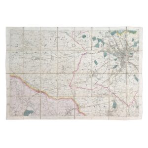
Whitehead’s Map of the Municipal Borough of Huddersfield – Folding Map – 1879
Huddersfield: George Whitehead & Sons, Lithographers, 1879.
Large-format separately issued municipal map of Huddersfield and its surrounding wards, printed and published by the noted local lithographic firm George Whitehead & Sons in 1879. Original outline hand-colouring. Dissected onto linen and housed in the original gilt-lettered cloth covers titled Borough of Huddersfield.
An exceptionally detailed and visually impressive Victorian municipal map produced shortly after Huddersfield’s incorporation as a municipal borough. The map delineates the borough boundaries and ward divisions in original colour, including Lindley-cum-Quarmby Ward, Marsh Ward, Fartown Ward, Dalton Ward, Almondbury-cum-Newsome Ward and adjoining districts. Roads, streets, railways, waterways, townships, public buildings, churches, schools and industrial features are carefully plotted throughout.
Of particular interest is the extensive printed reference table listing public buildings and institutions, including banks, chapels, schools, railway stations, mechanics’ institutes and civic buildings, offering a fascinating snapshot of Huddersfield’s late nineteenth-century urban infrastructure. The decorative title panel and compass rose add visual appeal, while the large scale and dissected format indicate that the map was intended for practical municipal and commercial use.
George Whitehead & Sons were among the principal Huddersfield printers and lithographers of the Victorian period, and separately issued municipal maps by the firm survive in comparatively small numbers. The map captures Huddersfield at the height of its industrial prosperity, documenting both the expanding urban centre and the surrounding semi-rural landscape before twentieth-century development transformed the borough.
A highly desirable local-history map combining civic, genealogical and topographical interest.
Sheet size: 105.8 x 87.2 cm.
Condition: Near fine overall. Dissected onto linen as issued, with very light age toning and very minor handling marks. Original covers are very clean. A strong and attractive example in lovely condition.
Why buy from us?
At Hornseys, we are committed to offering items that meet the highest standards of quality and authenticity. Our collection is meticulously curated to ensure that each item is a valuable and authentic piece of history. Here’s what sets us apart:
- Authenticity and Provenance: Every item is researched, collated, and verified for authenticity.
- Expert Curation: Each item is selected with a keen eye for significance, condition, and rarity, ensuring a collection that is both diverse and distinguished.
- Customer Satisfaction: We strive to provide an exceptional customer experience, from detailed descriptions and provenance to secure and prompt delivery of your purchase.
- Returns Policy: We offer an unconditional guarantee on every item. If you wish to make a return, items may be sent back to us within fourteen days of receipt for any reason. We request advance notification of returns, and items must be returned in the same condition as sent for a full refund.
Explore Our Collection:
Visit Hornseys to explore our fine collection of rare and signed books, maps, artwork and objects. Whether you are an avid collector or looking for a special gift, our selection offers something truly unique. Located in the picturesque Yorkshire Dales, our Ripon gallery has been a haven for book lovers, art enthusiasts, and collectors since 1976.
Thank you for looking.