Kuala Selangor – Malaya – G.S.G.S. 4203 – Sheet 3B/10 – Fourth Edition – 1949
Description:
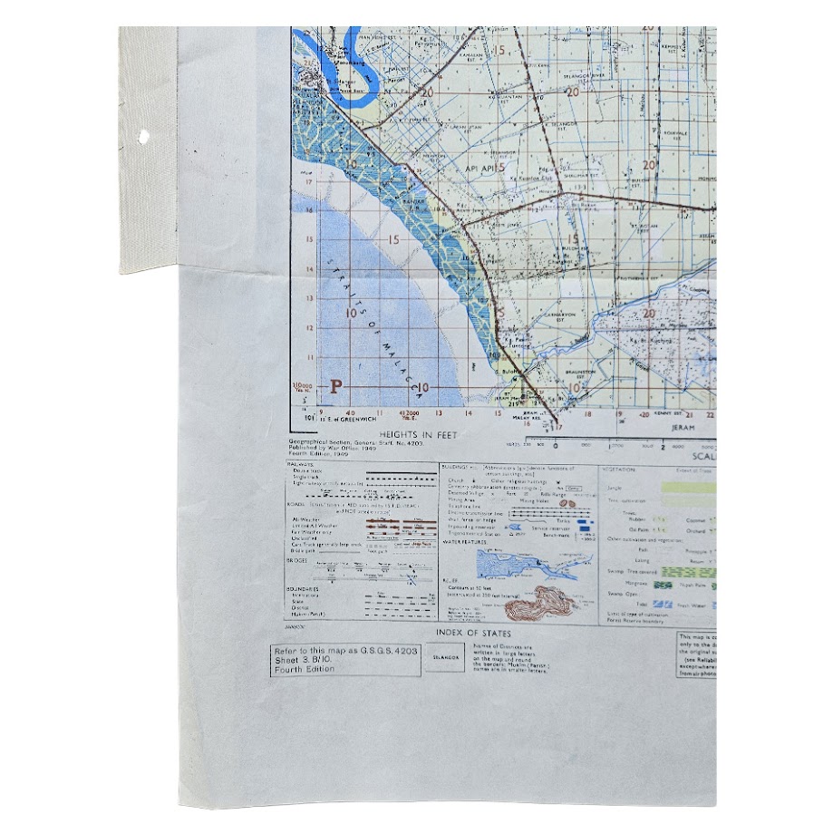
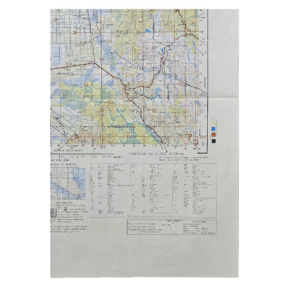
A detailed British military topographical map of the Kuala Selangor district on the west coast of the Malay Peninsula, published by the War Office as part of the important G.S.G.S. 4203 series of Malaya at one inch to one statute mile. This is Sheet 3B/10, Kuala Selangor, Fourth Edition, dated 1949.
The sheet extends from the low-lying coastal zone of the Straits of Malacca eastwards into the more elevated interior, recording Kuala Selangor and the surrounding settlements, roads, tracks, rivers, drainage systems, cultivated land and extensive areas of vegetation. The cartography is particularly detailed around the coastal plain, where the map records the intricate network of waterways, agricultural areas, communications and settlements that characterised this part of Selangor during the immediate post-war period.
Printed in several colours, the sheet distinguishes roads, watercourses, relief, cultivated areas and vegetation with considerable clarity. Contours are shown at 50-foot intervals. The lower margin incorporates an extensive key to buildings, communications, vegetation, water features and relief, together with an index to adjoining sheets and technical information concerning the survey and grid.
The map belongs to a sequence originally compiled from Federated Malay States surveys and subsequently revised during and immediately after the Second World War. The British Library preserves an earlier Fourth Edition of Kuala Selangor Sheet 3B/10, produced in 1945 from F.M.S. survey material with revisions derived partly from wartime aerial photography; the British Library catalogue specifically records intelligence information and road classification supplied by the Inter-Services Topographical Department, South East Asia Command. The present 1949 issue therefore forms part of the continuing post-war development of this strategically important military mapping programme.
Its date is also significant. By 1949 the Malayan Emergency was under way, having been declared in June 1948. Accurate large-scale mapping of roads, rivers, estates, jungle and settlement patterns became essential to British and Commonwealth military operations against the Malayan Communist Party and the Malayan National Liberation Army. Although there is no evidence that this particular sheet was operationally used, maps of this series and scale were the type of detailed topographical sheets required for military movement, patrol planning and administrative control during the Emergency.
Institutional survival confirms the significance of the series. The British Library’s India Office map collection contains Sheet 3B/10 and numerous adjoining sheets within its Malaya 1 Inch to 1 Mile holdings, while other institutional catalogues record the broader Malaya sheet series. Individual original examples of this particular Kuala Selangor sheet are considerably less conspicuous in the commercial market than the institutional record might suggest.
A particularly interesting map for collectors of Malaya and Malaysia, British colonial cartography, the Malayan Emergency, military surveying and the historical development of Selangor.
Condition: Very good. Original horizontal and vertical folds with some light handling and minor creasing. A series of filing holes to the extended left margin. Minor age-related marks and handling consistent with an original working map of this format. Printed colours remain strong and the map is complete and highly legible.
Maker: Geographical Section, General Staff / War Office.
Series: G.S.G.S. 4203.
Sheet: 3B/10 – Kuala Selangor.
Edition: Fourth Edition.
Date: 1949.
Scale: 1:63,360 – one inch to one statute mile.
Sheet Size: c. 71.5 × 55.6 cm.
Location: Tube A: Asia.
Historical Context:
The G.S.G.S. mapping of Malaya represents a particularly important phase in twentieth-century British military cartography. Earlier editions were revised during the closing stages of the Second World War using pre-war Federated Malay States surveys, aerial photography and intelligence supplied through South East Asia Command. The continuation of these sheets into the late 1940s coincided almost immediately with the outbreak of the Malayan Emergency, when accurate mapping of plantation country, roads, rivers and jungle terrain became strategically important.
The Kuala Selangor district lay within Selangor, one of the principal areas affected by the Emergency. Maps such as this provide a remarkably detailed contemporary record of the landscape before the extensive urban development and infrastructure changes of the later twentieth century.
Rarity:
Institutionally documented but commercially scarce in this exact sheet and issue. The British Library holds an earlier 1945 Fourth Edition of Sheet 3B/10, demonstrating continuity of the series, but we have not found evidence suggesting that the 1949 issue in commerce.
A detailed British military topographical map of Manong and the surrounding district of Perak, Malaya, published during the Malayan Emergency as Series L707 (GSGS 4690), Sheet 2M/8, Edition 2-GSGS. Prepared under the direction of the Assistant Director of Survey, Far East Land Forces, revised by 84 Field Survey Squadron, Royal Engineers, and drawn and printed by 570 Map Reproduction Troop, Royal Engineers, in November 1957.
Published at the highly detailed scale of one inch to one statute mile, or 1:63,360, the map centres on Manong and the Perak River valley south-west of Kuala Kangsar. It records roads, tracks and routes, settlements and kampongs, rivers and streams, cultivated areas, jungle, rubber plantations, relief, spot heights and other features important to both civilian administration and military movement.
The map is particularly notable for its exceptionally recent source material. The printed compilation statement records that it was revised by 84 Field Survey Squadron from Royal Air Force air-survey photography taken between November 1955 and May 1956, supplemented by ground survey revision in October 1957. The completed map was then drawn and printed by 570 Map Reproduction Troop in November 1957, making this an unusually immediate cartographic record of the terrain.
The earlier Edition 1 mapping on which it was partly based ultimately incorporated surveys extending back to December 1912, with revisions in 1914 and 1929. Edition 2 therefore represents a substantial post-war updating of older Malayan survey material through modern aerial photography and contemporary Royal Engineers fieldwork.
The sheet was produced during the Malayan Emergency, 1948–1960, when accurate large-scale mapping of roads, river crossings, settlements and jungle communications was of direct operational importance to British and Commonwealth forces conducting counter-insurgency operations against the Malayan National Liberation Army.
Of particular significance, the Australian War Memorial preserves an operational example of this precise Sheet 2M/8. That example was used by the Officer Commanding Mortar Platoon, Support Company, 2nd Battalion, Royal Australian Regiment during Operation Rubber Legs, 22 February–7 March 1957, and was specially treated to withstand the damp tropical environment. The institutional survival of an operationally used copy establishes the direct military relevance of this particular Manong sheet during the Emergency.
The present example is the later Edition 2-GSGS, incorporating the extensive aerial and ground-survey revision undertaken during 1957.
Topographically the map is exceptionally detailed. The broad course of the Perak River forms the principal feature, surrounded by a dense network of tributaries and drainage channels, with Manong, Parit and numerous kampongs represented alongside tracks penetrating the more sparsely settled and forested interior. The marginal key provides extensive conventional signs, abbreviations, vegetation information and an index to adjoining sheets.
Condition: Very good overall. Original folding creases and light handling and storage wear consistent with a working military map of the period. Punch holes to the extended left margin, evidently from former filing or storage. The printed image remains clear and the colours strong, with the extensive cartographic detail well preserved. Please refer to the photographs for a full visual assessment.
Publisher: Director of Survey, War Office and Air Ministry.
Military Survey: Prepared under the direction of the Assistant Director of Survey, Far East Land Forces; revised by 84 Field Survey Squadron, Royal Engineers; drawn and printed by 570 Map Reproduction Troop, Royal Engineers.
Series: Series L707 (GSGS 4690).
Sheet: 2M/8 – Manong.
Edition: Edition 2-GSGS.
Date: 1957
Scale: 1:63,360; one inch to one statute mile.
Sheet Size: Approximately 71.5 × 53.3 cm.
Material: Colour-printed paper map.
Construction
Single folding topographical sheet with extended filing margin, printed in colour with marginal reference tables, glossary, conventional signs and index to adjoining sheets.
Historical Context
The Malayan Emergency began in 1948 and developed into a prolonged counter-insurgency campaign fought largely in difficult tropical terrain. Mapping consequently played an important role in planning patrols, locating settlements and river crossings, identifying tracks and routes through jungle, coordinating units and defining operational areas.
Series L707 was part of the post-war British programme to provide modern large-scale mapping of Malaya. The combination of recent RAF aerial photography, ground-survey revision and production by Royal Engineers survey units demonstrates the close relationship between military intelligence, aerial reconnaissance and cartography during the Emergency.
The dating of this particular edition is especially interesting: ground revision was undertaken as late as October 1957, followed by printing the following month. It therefore represents contemporary military geographical intelligence rather than a simple reissue of older colonial mapping.
Rarity
Series L707 is represented in major institutional collections, including the British Library, National Archives of Singapore, Australian War Memorial and specialist university map collections. Individual sheets, however, survive very unevenly.
Sheet 2M/8 Manong is institutionally documented but is not commonly encountered in the commercial market. Its importance is enhanced by the survival at the Australian War Memorial of an operational copy of this exact sheet used during the Malayan Emergency. The present 1957 Edition 2-GSGS is particularly desirable because it incorporates RAF aerial photography and Royal Engineers ground revision undertaken that same year.
The map is best described as scarce in commerce and historically significant within the Malayan Emergency mapping series, rather than universally rare as a GSGS map.
Location: Tube A: Asia
SHOP WITH CONFIDENCE AT HORNSEYS
At Hornseys, we are dedicated to offering items that uphold the highest standards of quality and authenticity. Our collection of artwork is carefully curated to ensure that each item we offer is authentic, collated, and complete.
Here’s what sets us apart:
- Authenticity and Provenance: Each map is researched and verified for authenticity.
- Expert Curation: We wholly own all our artworks. We trust our taste and have invested heavily in it. We have confidence in all artwork that we offer for sale.
- Customer Satisfaction: We strive to provide an exceptional customer experience, from detailed descriptions and provenance to secure and prompt delivery of your purchase.
- Returns Policy: We offer an unconditional guarantee on every item. If, however, you wish to make a return, artworks may be sent back to us within fourteen days of receipt for whatever reason. We request that we are notified in advance if you wish to do so. They must be returned to us in the same condition as they were sent for a full refund.
OUR COMMITMENT TO QUALITY AND SERVICE
Understanding the value and rarity of these items, we ensure that every aspect of your purchase meets the highest standards of quality and service. This includes:
- Free Expedited, Tracked, and Insured Delivery within the UK: Ensuring that your artwork arrives safely and promptly.
- Fully-Insured Worldwide Delivery: Offering peace of mind for international collectors with reliable and secure shipping options.
EXPLORE OUR COLLECTION
Visit Hornseys today to explore our fine collection of maps and other artworks. Whether you are an avid collector or looking for a special gift, our selection offers something truly unique. Located since 1976 in Ripon in the picturesque Yorkshire Dales, we are recognized as a destination gallery for tastefully curated artwork, rare maps, design, and fine books.