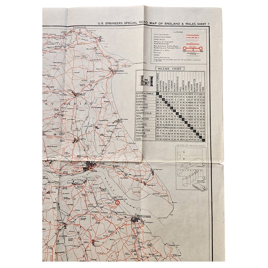
U.S. Engineers Special Road Map of England & Wales – Sheet 7 – Yorkshire, Lancashire, Lincolnshire & Northern England – Second World War – c.1940s
Description: A large original Second World War U.S. Engineers Special Road Map of England & Wales, Sheet 7, produced for American military use in Britain and covering a strategically important swathe of northern England. Measuring an impressive 50.4 × 102 cm, the map extends across Yorkshire, Lancashire and Lincolnshire, with major centres including York, Leeds, Bradford, Halifax, Harrogate, Ripon, Hull, Scarborough, Doncaster, Sheffield, Liverpool, Manchester and Grimsby prominently represented. The road network is printed principally in red over a detailed black base map, with first-class and second-class roads, other roads, Ministry of Transport road numbering, railway routes, canals, county boundaries and important urban centres differentiated for rapid military reference. A substantial mileage table provides road distances between principal northern cities and towns, while the accompanying legend and folding instructions emphasise that this was conceived as a practical transport and logistical map rather than a conventional civilian road map.
The map belongs to a specialised series prepared for U.S. military personnel operating in Britain during the Second World War, at a time when the country was being used on an unprecedented scale as a base for the build-up of American and Allied forces ahead of operations in continental Europe. Surviving examples of other sheets in the series are explicitly described as being intended for War and Navy Department agencies, reinforcing their military rather than commercial function. Comparable sheets from the series survive on the market, although examples of Sheet 7 are relatively infrequently encountered.
Of particular local interest is the prominent inclusion of Ripon. During the Second World War the city and its surrounding military infrastructure once again played an important training role. Imperial War Museums records document Royal Engineers personnel undergoing recruit training with the 3rd Training Battalion, Royal Engineers, at Ripon during 1940–41, while another wartime memoir records service at Harper Barracks, Ripon before onward posting. Historic England also records extensive twentieth-century military training and defensive activity around Ripon, including Second World War training areas. For American and Allied forces moving through Britain, road maps of this type were therefore part of the logistical infrastructure needed to move troops, vehicles and materiel between camps, ports, railheads and operational centres.
The geographical coverage gives the sheet considerable interest beyond Ripon. Hull and Grimsby were major east-coast ports; Liverpool and Manchester were central to Atlantic supply and industrial logistics; and Leeds, Bradford and Sheffield sat at the heart of some of Britain’s most important wartime industrial districts. The concentration of roads and urban centres across the map vividly illustrates the transport network upon which wartime Britain depended.
Condition: Very good condition for a large wartime working map. Original folding throughout, with light handling, creasing and minor age-related marking. otherwise the map remains complete and highly presentable, with strong red and black printing and good clarity throughout. Please study the accompanying photographs carefully as they form an important part of the condition assessment.
Title: U.S. Engineers Special Road Map of England & Wales, Sheet 7
Authority: U.S. Engineers
Date: Second World War, circa 1940s
Sheet: 7
Area: Yorkshire, Lancashire, Lincolnshire and northern England
Principal places shown: Ripon, York, Harrogate, Leeds, Bradford, Halifax, Sheffield, Hull, Scarborough, Doncaster, Liverpool, Manchester and Grimsby
Sheet size: 50.4 × 102 cm
Format: Large folding colour road and military transport map
Every map offered by Hornseys is handled, inspected and catalogued individually in-house, with edition, imprint, cartographic content and condition assessed directly from the original sheet wherever possible.
SHOP WITH CONFIDENCE AT HORNSEYS
At Hornseys, we are dedicated to offering items that uphold the highest standards of quality and authenticity. Our collection of artwork is carefully curated to ensure that each item we offer is authentic, collated, and complete.
Here’s what sets us apart:
- Authenticity and Provenance: Each map is researched and verified for authenticity.
- Expert Curation: We wholly own all our artworks. We trust our taste and have invested heavily in it. We have confidence in all artwork that we offer for sale.
- Customer Satisfaction: We strive to provide an exceptional customer experience, from detailed descriptions and provenance to secure and prompt delivery of your purchase.
- Returns Policy: We offer an unconditional guarantee on every item. If, however, you wish to make a return, artworks may be sent back to us within fourteen days of receipt for whatever reason. We request that we are notified in advance if you wish to do so. They must be returned to us in the same condition as they were sent for a full refund.
OUR COMMITMENT TO QUALITY AND SERVICE
Understanding the value and rarity of these items, we ensure that every aspect of your purchase meets the highest standards of quality and service. This includes:
- Free Expedited, Tracked, and Insured Delivery within the UK: Ensuring that your artwork arrives safely and promptly.
- Fully-Insured Worldwide Delivery: Offering peace of mind for international collectors with reliable and secure shipping options.
EXPLORE OUR COLLECTION
Visit Hornseys today to explore our fine collection of maps and other artworks. Whether you are an avid collector or looking for a special gift, our selection offers something truly unique. Located since 1976 in Ripon in the picturesque Yorkshire Dales, we are recognized as a destination gallery for tastefully curated artwork, rare maps, design, and fine books.