-
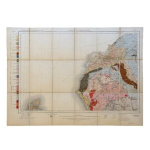
Geological Survey of England and Wales / Ordnance Survey – Sheet 3: Lake District – 1907 – Folding Map
£95.00Geological Survey of England and Wales / Ordnance Survey
-
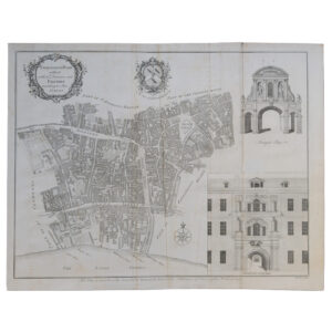
London – Farringdon Ward Without With Its Division Into Parishes According to A New Survey – 1755
£95.00Cole, Benjamin & Mailtand, William
-

-
-

Spanning East Africa – Standard-Vacuum Road Map – Tanganyika – Kenya And Uganda
£95.00Standard-Vacuum Oil Company (East Africa) Limited
-

-

-

Sheet 11 – Lydenburg – Union Of South Africa Department Of Mines And Industries – Geological Survey
£95.00Hall, A. L & Mellor, E. T
-

Geological Map Of The Colony Of The Cape Of Good Hope Sheet 13 – Beaufort West – Fraserburg
£95.00Rogers, A. W. & Schwarz, E. H. L
-

-

-

-

-

-

-

-

-

Geological Map Of The Country Around Heidelberg – Union Of South Africa – 1922 – First Edition
£95.00Rogers, J. W.& Nel, L. T
-

-

MIDDLE EAST WITH BOUNDARIES ROADS AND RAILWAYS CONTOUR COLOURED WORLD MAP SERIES 1959 – SHOWS THE UNITED ARAB REPUBLIC
£95.00The Geographical Institute, Edinburgh
-

-

ANTIQUORUM AFRICAE EPISCOPA TUUM GEOGRAPHIA DESCRIPTIO – 1640 – NORTHERN AFRICA
£95.00Tavernier, Melchior
-

Département Des Côtes-du-Nord Décrété Le 30 Janvier 1790 Par L’Assemblée Nationale Divisé En 9 Districts Et 81 Cantons – Atlas National De France Sheet 44
£95.00Dumez, Pierre & Chanlaire, Pierre-Grégoire
-

-

Ordnance Survey Map Of The Ripon – Masham – Richmond – Northallerton Area – Copy of The North Eastern Railway Office In York
£95.00The Ordnance Survey & The North Eastern Railway
-

-

Berlin is Calling The World, Visit The City Of The Freedom Bell
£95.00Deutsche Zentrale Fur Frembenverkehr
-

-

-

-

United Kingdom – Tabula Geographica Angliae Walliae Ad Emendatiora Exempla
£95.00Von Euler, Leonard
-
