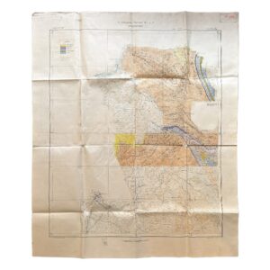
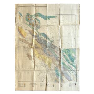
Iran – Persia – Qasr-i-Shirin Area. To Accompany Report M.H.L. 7 – Geological Map – 1929
£2,000.00Anglo-Persian Oil Company
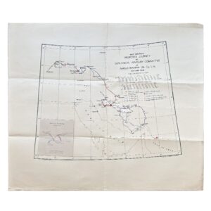
Iran – Map Showing Proposed Journey By Geological Advisory Committee Of Anglo-Iranian Oil Co. Ltd., Autumn 1936
£1,800.00Geological Advisory Committee (Iran)
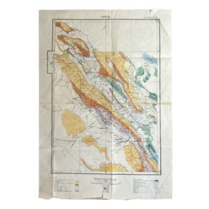
Persia. No. 9 H.E. 10.E – Geological Map Of South-West Iran Including The Masjid-I-Sulaiman And Haft Kel Oil Regions – 1929
£950.00Cornes, H & Anglo-Persian Oil Company (A.P.O.C.)
Persia. No. 9 H.E. 10.E – Geological Map Of South-West Iran Including The Masjid-I-Sulaiman And Haft Kel Oil Regions – 1929/35
£950.00Cornes, H & Anglo-Persian Oil Company (A.P.O.C.)
Iran – Persia – Masjid-i-Sulaiman Road Map – South-West Iran – Khuzestan Province – Masjid-i-Sulaiman Oilfield District – c.1949-54
£750.00Anglo-Iranian Oil Company (A.I.O.C.)
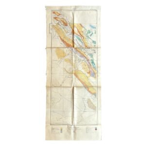
Persia – A.P.O.C. Geological Map Of South-West Iran – Zagros Oilfields – Sheet No. 10 I & 10 J – 1929
£500.00Cornes, H & Anglo-Persian Oil Company (A.P.O.C.)
Geological Map Of Israel – Revised Edition – 1976 – Map On Two Sheets
£450.00Picard, L. Y, Golani, U, Bentor, Y. K, Vroman, A & Zak, I
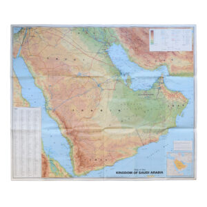
Saudi Arabia With City Maps Of Riyadh Jeddah And Dammam – Second Edition
£250.00GEOprojects Arab World Map Library
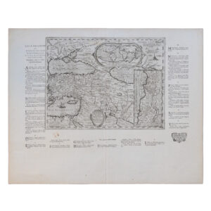
ASIA – PLATE 4 – INCLUDING THE TURKISH DOMINIONS WITH MOST OF PERSIA REVISED AND EXAMINED BY MR BOLTON – ASIA – PLATE 5 – PART OF INDIA PERSIA TIBET AND TARTARY EXAMINED AND RECTIFIED BY MR BOLTON
£100.00D’Anville, Jean Baptiste Bourguignon, Searle, Richard William & Bolton, Solomon
MIDDLE EAST WITH BOUNDARIES ROADS AND RAILWAYS CONTOUR COLOURED WORLD MAP SERIES 1959 – SHOWS THE UNITED ARAB REPUBLIC
£95.00The Geographical Institute, Edinburgh
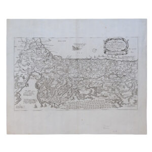
MIDDLE EAST AND NEAR EAST – PERSIA – ARABIA – TURKEY – EGYPT – WITH BOUNDARIES ROADS AND RAILWAYS – CONTOUR-COLOURED WORLD MAP SERIES – 1956
£45.00The Geographical Institute, Edinburgh