Abyssinia – British War Office Army/Air Map, G.S.G.S. 2871, Fifth Edition, 1948
Description:
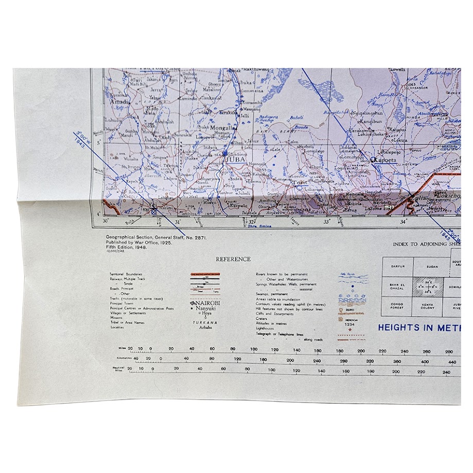
An original British military and air-navigation map of Abyssinia, now Ethiopia, issued by the Geographical Section, General Staff as part of the important Africa 1:2,000,000 series, G.S.G.S. 2871. This is the Army/Air Fifth Edition, published in 1948, and measures 63 × 83.3 cm.
The map covers a very extensive area of north-eastern Africa centred on Ethiopia, extending westwards into the Anglo-Egyptian Sudan, southwards towards Kenya and the Juba region, and eastwards towards the Somali territories. Major centres including Addis Ababa, Gondar, Dessie, Dire Dawa, Harar, Jimma and Juba are shown, together with Lake Tana and the principal road, railway and river systems of the region.
Relief is represented by a particularly striking system of graduated purple altitude tints, contours and spot heights, clearly expressing the Ethiopian Highlands and their surrounding escarpments. International and administrative boundaries, permanent and seasonal water sources, railways, principal and secondary roads, tracks, settlements, telegraph communications and other topographical information are shown in considerable detail.
The map retains the specialised Army/Air information added for military and aviation use, including aerodromes, landing grounds and associated reference data. The lower margin contains the original boundary diagram, adjoining-sheet index, scale, conventional signs, altitude key and detailed notes concerning the cartographic and aeronautical sources used in its compilation.
The cartographic history is particularly interesting. The G.S.G.S. 2871 Abyssinia sheet originated in the inter-war British War Office mapping programme and was repeatedly revised as strategic knowledge of Ethiopia and surrounding territories improved. The present Fifth Edition incorporates information derived from East African Forces wartime mapping, including material prepared during the East African campaign and subsequent military administration. Although issued after the Second World War, it preserves and consolidates wartime military, air and topographical intelligence gathered across Ethiopia, Sudan, Kenya and neighbouring territories.
The sheet states that it was reprinted from E.A.F. 1204, First Edition, 1943, and reproduced by the War Office in 1948. It therefore represents the post-war culmination of a cartographic sequence heavily shaped by British military operations in East Africa between 1940 and 1945.
A large, visually impressive and highly detailed British military map of Ethiopia and north-eastern Africa, of particular interest for the history of British military surveying, aviation, the East African campaign and the cartographic representation of Ethiopia during the transition from wartime to post-war administration.
Condition
Very good. Original issue folds with light handling and minor marginal creasing. A small contemporary pencil numeral appears in the upper right margin. The colours remain exceptionally strong and the map is complete and highly legible, with no significant loss.
Title: Abyssinia
Publisher: War Office
Issuing Authority: Geographical Section, General Staff
Series: Africa 1:2,000,000 – G.S.G.S. 2871
Edition: Army/Air Fifth Edition
Date: 1948
Scale: 1:2,000,000
Size: 63 × 83.3 cm
Printing: Colour-printed military topographical map
Area: Ethiopia, adjoining Sudan, Kenya and Somali territories
Location: Tube B: Africa
Inventory Number: 004111
SHOP WITH CONFIDENCE AT HORNSEYS
At Hornseys, we are dedicated to offering items that uphold the highest standards of quality and authenticity. Our collection of artwork is carefully curated to ensure that each item we offer is authentic, collated, and complete.
Here’s what sets us apart:
- Authenticity and Provenance: Each map is researched and verified for authenticity.
- Expert Curation: We wholly own all our artworks. We trust our taste and have invested heavily in it. We have confidence in all artwork that we offer for sale.
- Customer Satisfaction: We strive to provide an exceptional customer experience, from detailed descriptions and provenance to secure and prompt delivery of your purchase.
- Returns Policy: We offer an unconditional guarantee on every item. If, however, you wish to make a return, artworks may be sent back to us within fourteen days of receipt for whatever reason. We request that we are notified in advance if you wish to do so. They must be returned to us in the same condition as they were sent for a full refund.
OUR COMMITMENT TO QUALITY AND SERVICE
Understanding the value and rarity of these items, we ensure that every aspect of your purchase meets the highest standards of quality and service. This includes:
- Free Expedited, Tracked, and Insured Delivery within the UK: Ensuring that your artwork arrives safely and promptly.
- Fully-Insured Worldwide Delivery: Offering peace of mind for international collectors with reliable and secure shipping options.
EXPLORE OUR COLLECTION
Visit Hornseys today to explore our fine collection of maps and other artworks. Whether you are an avid collector or looking for a special gift, our selection offers something truly unique. Located since 1976 in Ripon in the picturesque Yorkshire Dales, we are recognized as a destination gallery for tastefully curated artwork, rare maps, design, and fine books.