Godāvari, India – British War Office Army/Air Map, G.S.G.S. 2555, Sheet NE-44
Description:
An original British War Office military and air-navigation map of Godāvari and the eastern Deccan, issued as Sheet NE-44 in the important Asia 1:1,000,000 series, G.S.G.S. 2555. The sheet is designated First Edition, Army/Air Style and covers a substantial area of central and eastern India extending from the interior of the Deccan Plateau to the Bay of Bengal, including the lower Godavari river system and delta.
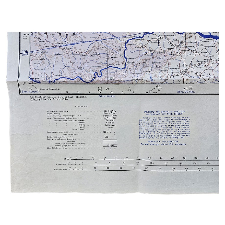
The map was copied from a Survey of India map of 1940, photolithographed by the War Office in 1943 and first published by the Geographical Section, General Staff in 1944. This example is recorded as a later 1946 issue/impression; the printed sheet itself retains the original 1944 first-edition publication statement.
The geographical coverage encompasses parts of the former Central Provinces, Eastern States, Hyderabad, Madras Presidency and Orissa, with the extensive Godavari drainage system dominating the southern and eastern portions. The river and its tributaries are strongly delineated in blue, terminating in the complex delta system opening into the Bay of Bengal. Major towns, district headquarters, roads, railways, rivers, canals, reservoirs, boundaries and settlements are represented in considerable detail.
The designation Army/Air Style reflects the dual military and aviation purpose of the sheet. In addition to conventional topographical information, the map incorporates navigational reference data, altitude information, magnetic declination and the positional-reference system required for operational use. The lower margin retains the full original technical apparatus, including reference keys, adjoining-sheet diagram, distance scales and instructions for determining positions on the sheet.
This map belongs to the long-running G.S.G.S. 2555 Asia 1:1,000,000 series, developed by the British War Office from the International Map of the World framework and extensively revised during the Second World War. The Godāvari sheet was particularly relevant to wartime communications across eastern and central India, depicting important railway corridors, road systems, river crossings and the strategically significant Bay of Bengal coastline.
A good example of British Second World War military cartography of India, combining Survey of India source material with War Office Army/Air requirements and providing a detailed record of the administrative, transport and physical geography of the Godavari region during the final years of British rule.
Condition
Very good. Original issue folds with light handling and minor creasing, principally to the margins and along fold lines. Small old manuscript or collection label marked “A7” to the lower right margin. The map remains complete, clean and highly legible, with strong blue and red printing and no significant loss.
Title: Godāvari
Publisher: Geographical Section, General Staff, War Office
Series: Asia 1:1,000,000 – G.S.G.S. 2555
Sheet: NE-44
Edition: First Edition, Army/Air Style
Source: Survey of India map, 1940
War Office Photolithography: 1943
First Publication: 1944
Date of this example: 1946
Scale: 1:1,000,000
Size: 64.6 × 72.6 cm
Format: Colour-printed military and air-navigation map
Location: Tube A: Asia
Inventory Number: 004112
SHOP WITH CONFIDENCE AT HORNSEYS
At Hornseys, we are dedicated to offering items that uphold the highest standards of quality and authenticity. Our collection of artwork is carefully curated to ensure that each item we offer is authentic, collated, and complete.
Here’s what sets us apart:
- Authenticity and Provenance: Each map is researched and verified for authenticity.
- Expert Curation: We wholly own all our artworks. We trust our taste and have invested heavily in it. We have confidence in all artwork that we offer for sale.
- Customer Satisfaction: We strive to provide an exceptional customer experience, from detailed descriptions and provenance to secure and prompt delivery of your purchase.
- Returns Policy: We offer an unconditional guarantee on every item. If, however, you wish to make a return, artworks may be sent back to us within fourteen days of receipt for whatever reason. We request that we are notified in advance if you wish to do so. They must be returned to us in the same condition as they were sent for a full refund.
OUR COMMITMENT TO QUALITY AND SERVICE
Understanding the value and rarity of these items, we ensure that every aspect of your purchase meets the highest standards of quality and service. This includes:
- Free Expedited, Tracked, and Insured Delivery within the UK: Ensuring that your artwork arrives safely and promptly.
- Fully-Insured Worldwide Delivery: Offering peace of mind for international collectors with reliable and secure shipping options.
EXPLORE OUR COLLECTION
Visit Hornseys today to explore our fine collection of maps and other artworks. Whether you are an avid collector or looking for a special gift, our selection offers something truly unique. Located since 1976 in Ripon in the picturesque Yorkshire Dales, we are recognized as a destination gallery for tastefully curated artwork, rare maps, design, and fine books.