Upper Mekong – British War Office Army/Air Map, HIND 5000, Sheet NH-47, 1943
Description:
An original British military and air-navigation map of the Upper Mekong region, issued as Sheet NH-47 in the British HIND 5000 series at a scale of 1:1,000,000. Marked “For official use only” and designated Army/Air Edition 1943, the sheet covers a remote and strategically important region extending across the eastern Tibetan Plateau and adjoining parts of south-western China and the Himalayan borderlands.
The map encompasses approximately 28°–32° north latitude and 96°–102° east longitude, including sections of the upper courses and watershed systems of the Mekong, Salween and adjacent great Asian rivers. The terrain is exceptionally mountainous, and the cartography is dominated by closely drawn contours, spot heights, passes, river valleys and tracks. Numerous settlements, monasteries, administrative centres, routes and geographic features are named, providing an unusually detailed wartime representation of an area that remained difficult to survey and comparatively poorly mapped.
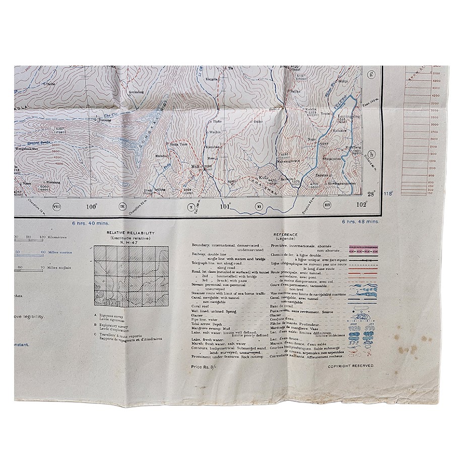
The sheet is particularly notable for its relative reliability diagram, which distinguishes areas based on rigorous survey, exploratory survey, travellers’ route reports and other sources. This is an important feature of British mapping of Tibet and western China, openly indicating the uneven quality of geographical knowledge in this remote region. Later intelligence assessments continued to use these British Survey of India sources when evaluating the accuracy of mapping in eastern Tibet and the Upper Mekong region.
The map was produced for military use during the Second World War and carries the instruction “Refer to this map as: HIND 5000, Sheet NH.47.” Its bilingual English/French reference key records international and administrative boundaries, roads, tracks, telegraph lines, settlements, monasteries, landing grounds, rivers, glaciers, marshes, springs, wells and other terrain features. Relief is represented by dense contours and spot heights, with selected boundaries and communications picked out in red, blue and violet.
Of particular historical interest is the map’s relationship with later 1945 HIND 5000 First Edition issues. The British Library catalogue identifies its Upper Mekong NH-47 sheet as having an Army/Air Edition of 1943, subsequently reprinted as the First Edition in 1945. The present map is therefore the earlier wartime state rather than the later post-production reprint.
The geographical area represented later became central to the Chinese advance into eastern Tibet, including the approaches towards Chamdo, making this wartime British mapping especially valuable as a record of western geographical knowledge immediately before the major geopolitical changes of the late 1940s and early 1950s.
A scarce and highly evocative Second World War military map of one of the least accessible parts of Asia, combining Survey of India geographical intelligence with British Army and Air requirements.
Condition
Good to very good. Original issue folds with handling creases and some marginal wear. Localised foxing and spotting, principally towards the lower right margin, together with some short marginal creases and minor edge wear. The cartographic field remains complete, clean and highly legible, with strong original colour and no significant loss.
Title: Upper Mekong
Issuing Authority: British military mapping service / Survey of India-derived HIND series
Series: HIND 5000
Sheet: NH-47
Edition: Army/Air Edition
Date: 1943
Scale: 1:1,000,000
Size: 66.2 × 69.1 cm
Coverage: Eastern Tibet and adjoining Upper Mekong region
Security Marking: For official use only
Format: Colour-printed military and air-navigation map
Location: Tube A: Asia
Inventory Number: 004113
SHOP WITH CONFIDENCE AT HORNSEYS
At Hornseys, we are dedicated to offering items that uphold the highest standards of quality and authenticity. Our collection of artwork is carefully curated to ensure that each item we offer is authentic, collated, and complete.
Here’s what sets us apart:
- Authenticity and Provenance: Each map is researched and verified for authenticity.
- Expert Curation: We wholly own all our artworks. We trust our taste and have invested heavily in it. We have confidence in all artwork that we offer for sale.
- Customer Satisfaction: We strive to provide an exceptional customer experience, from detailed descriptions and provenance to secure and prompt delivery of your purchase.
- Returns Policy: We offer an unconditional guarantee on every item. If, however, you wish to make a return, artworks may be sent back to us within fourteen days of receipt for whatever reason. We request that we are notified in advance if you wish to do so. They must be returned to us in the same condition as they were sent for a full refund.
OUR COMMITMENT TO QUALITY AND SERVICE
Understanding the value and rarity of these items, we ensure that every aspect of your purchase meets the highest standards of quality and service. This includes:
- Free Expedited, Tracked, and Insured Delivery within the UK: Ensuring that your artwork arrives safely and promptly.
- Fully-Insured Worldwide Delivery: Offering peace of mind for international collectors with reliable and secure shipping options.
EXPLORE OUR COLLECTION
Visit Hornseys today to explore our fine collection of maps and other artworks. Whether you are an avid collector or looking for a special gift, our selection offers something truly unique. Located since 1976 in Ripon in the picturesque Yorkshire Dales, we are recognized as a destination gallery for tastefully curated artwork, rare maps, design, and fine books.