Philippine Islands – War Office, Asia 1:4,000,000, Sheet 47. Wartime Issue, 1943
Description:
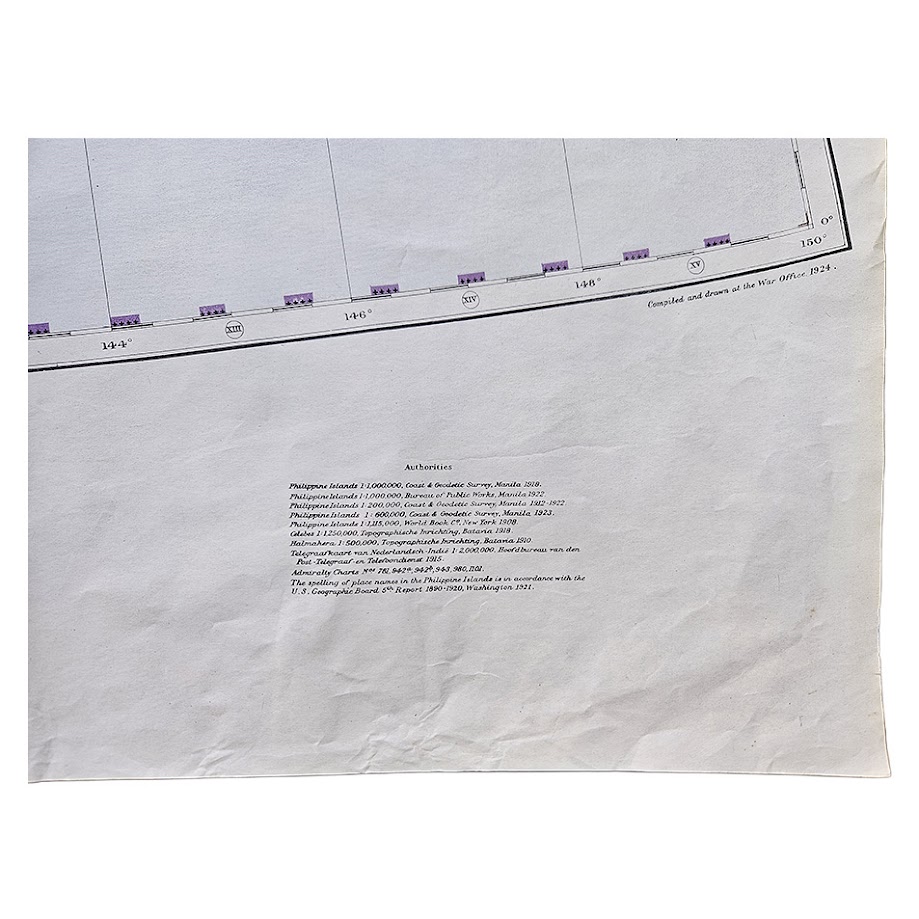
A large and visually impressive British War Office map of the Philippine Islands and the western Pacific, issued as Sheet 47 of the Asia 1:4,000,000 series. The cartographic plate is identified as the First Edition, originally compiled and drawn at the War Office in 1924; this example dates from 1943, representing a wartime issue of a map whose geographical coverage had acquired exceptional strategic significance following the Japanese occupation of the Philippines.
At the large regional scale of 1:4,000,000, the sheet encompasses virtually the entire Philippine archipelago from Luzon and Manila south through the Visayas and Mindanao, together with the Sulu Archipelago, Palawan, northern Borneo, the Celebes/Moluccas region and the Mariana and Caroline Islands extending eastwards into the Pacific. The Philippines are rendered in colour with relief represented through graduated hypsometric tinting, while coastlines, settlements, railways, roads, communications, political boundaries and principal physical features are differentiated throughout.
The geographic scope is particularly important in the context of the Pacific War. By 1943 the Philippines had been under Japanese occupation for more than a year, following the campaigns of 1941–42, while Allied strategic planning increasingly focused on a return to the western Pacific. The sheet therefore depicts one of the principal theatres of the later Pacific campaign at a point when the archipelago, surrounding seas and island groups were central to military planning.
The map also records the pre-war political geography of the region. The Philippine Islands, then a Commonwealth under United States sovereignty, are shown alongside neighbouring colonial territories and Pacific island groups. International and administrative boundaries are picked out in violet, while the extensive surrounding ocean gives the map a strong strategic character, clearly demonstrating the Philippines’ position between the South China Sea, East Indies and western Pacific.
The lower margin includes an extensive list of cartographic authorities used in compiling the original sheet, including Philippine Coast and Geodetic Survey mapping, United States Coast and Geodetic Survey material, hydrographic publications and contemporary European mapping. This provides useful evidence of the multinational source base from which the War Office constructed its regional map.
Sheet 47 formed part of the important War Office Asia 1:4,000,000 series, subsequently designated G.S.G.S. 2957. The series was used and adapted by several military powers during the Second World War, including American and German military mapping organisations. The Philippine sheet in particular was reproduced and adapted during the early 1940s because of the strategic importance of the archipelago.
A substantial and highly decorative wartime map with particular interest for collectors of the Philippines, the Pacific War, British military cartography and twentieth-century Asian mapping.
Condition
Good to very good. Original folding with general handling and creasing, minor marginal wear and several small edge tears, most noticeably along the upper and right margins. Some light age-toning and occasional marks. The printed area remains complete and highly legible, with strong original blue, green, ochre and violet colouring.
Title: Philippine Islands
Series: Asia 1:4,000,000
Sheet: 47
Edition: First Edition plate
Original Compilation: War Office, 1924
Issue Date: 1943
Publisher: War Office
Scale: 1:4,000,000
Size: 82.6 × 108.5 cm
Format: Colour-printed topographical and strategic map
Location: Tube A: Asia
Inventory Number: 004119
SHOP WITH CONFIDENCE AT HORNSEYS
At Hornseys, we are dedicated to offering items that uphold the highest standards of quality and authenticity. Our collection of artwork is carefully curated to ensure that each item we offer is authentic, collated, and complete.
Here’s what sets us apart:
- Authenticity and Provenance: Each map is researched and verified for authenticity.
- Expert Curation: We wholly own all our artworks. We trust our taste and have invested heavily in it. We have confidence in all artwork that we offer for sale.
- Customer Satisfaction: We strive to provide an exceptional customer experience, from detailed descriptions and provenance to secure and prompt delivery of your purchase.
- Returns Policy: We offer an unconditional guarantee on every item. If, however, you wish to make a return, artworks may be sent back to us within fourteen days of receipt for whatever reason. We request that we are notified in advance if you wish to do so. They must be returned to us in the same condition as they were sent for a full refund.
OUR COMMITMENT TO QUALITY AND SERVICE
Understanding the value and rarity of these items, we ensure that every aspect of your purchase meets the highest standards of quality and service. This includes:
- Free Expedited, Tracked, and Insured Delivery within the UK: Ensuring that your artwork arrives safely and promptly.
- Fully-Insured Worldwide Delivery: Offering peace of mind for international collectors with reliable and secure shipping options.
EXPLORE OUR COLLECTION
Visit Hornseys today to explore our fine collection of maps and other artworks. Whether you are an avid collector or looking for a special gift, our selection offers something truly unique. Located since 1976 in Ripon in the picturesque Yorkshire Dales, we are recognized as a destination gallery for tastefully curated artwork, rare maps, design, and fine books.